Bendemeer, Singapore
Bendemeer (Chinese: 明地迷亚, Tamil: பென்ட்டிமியிர்) is a subzone within the planning area of Kallang, Singapore, as defined by the Urban Redevelopment Authority (URA). Its boundary is made up of the Pan Island Expressway (PIE) in the north; Serangoon Road, the Kallang River, Sungei Whampoa and Bendemeer Road in the east; Lavender Street and Balestier Road in the south; and the Central Expressway (CTE) in the west.[1]
Bendemeer | |
|---|---|
Subzone of Kallang Planning Area | |
| Other transcription(s) | |
| • Chinese | 明地迷亚 |
| • Malay | Bendemeer |
| • Tamil | பென்ட்டிமியிர் |
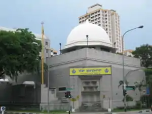 .jpg.webp)  Row 1: Central Sikh Temple Row 2, left: Block 44 Bendemeer Road Row 2, right: River Vista @ Kallang at the confluence of the Kallang River and Sungei Whampoa | |
| Country | |
| Region | Central Region |
| Planning Area | Kallang |
Bendemeer is primarily residential, consisting of both public housing built by the Housing and Development Board (HDB) and private housing. Educational institutions within this subzone include Hong Wen School, Bendemeer Primary School, Bendemeer Secondary School and Northlight School.
Other notable places within Bendemeer include Boon Keng MRT station along the North East Line, Kwong Wai Shiu Hospital, Kallang Community Club, Kallang Neighbourhood Police Post, Boon Keng Fire Post and Central Sikh Temple. The upcoming Kallang Polyclinic will be sited within this subzone.
External links
![]() Media related to Kallang Planning Area at Wikimedia Commons
Media related to Kallang Planning Area at Wikimedia Commons
| Organisations | 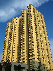 | |
|---|---|---|
| Building Programmes |
| |
| Upgrading Programmes |
| |
| Other | ||