Mariposa-Yosemite Airport
Mariposa-Yosemite Airport (IATA: RMY, ICAO: KMPI, FAA LID: MPI, formerly O68) is a public airport located four miles (6 km) west of the central business district of Mariposa, in Mariposa County, California, United States. It is owned by the County of Mariposa.[1]
Mariposa-Yosemite Airport Mariposa Air Force Auxiliary Field | |||||||||||
|---|---|---|---|---|---|---|---|---|---|---|---|
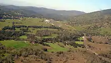
 2015 aerial photo | |||||||||||
| Summary | |||||||||||
| Airport type | Public | ||||||||||
| Owner | County of Mariposa | ||||||||||
| Location | Mariposa, California | ||||||||||
| Elevation AMSL | 2,254 ft / 687 m | ||||||||||
| Coordinates | 37°30′39″N 120°02′22″W | ||||||||||
| Map | |||||||||||
 KMPI Location of Mariposa-Yosemite Airport | |||||||||||
| Runways | |||||||||||
| |||||||||||
| Statistics (2007) | |||||||||||
| |||||||||||
Although most U.S. airports use the same three-letter location identifier for the FAA and IATA, Mariposa-Yosemite Airport is assigned MPI by the FAA but the IATA assigned MPI to Mamitupo, Panama).[2]
Facilities and aircraft
Mariposa-Yosemite Airport covers an area of 100 acres (40 ha) which contains one asphalt paved runway (8/26) measuring 3,306 x 60 ft (1,008 x 18 m).[1]
For the 12-month period ending March 2, 2007, the Mariposa-Yosemite airport had 32,000 aircraft operations, an average of 87 per day: 94% general aviation and 6% air taxi. There are 52 aircraft based at this airport: 96% single engine, 2% multi-engine and 2% ultralight.[1]
There is one FBO on the field, Airborrn Aviation Services.[3]
World War II
During World War II, the airport was designated as Mariposa Air Force Auxiliary Field, and was an auxiliary training airfield for Merced Army Airfield, California.
References
![]() This article incorporates public domain material from the Air Force Historical Research Agency website http://www.afhra.af.mil/.
This article incorporates public domain material from the Air Force Historical Research Agency website http://www.afhra.af.mil/.
- FAA Airport Form 5010 for MPI PDF, effective 2007-07-05
- Great Circle Mapper: MPI - Mamitupo, Panamá
- Yosemite Aviation
External links
- Resources for this airport:
- FAA airport information for MPI
- AirNav airport information for MPI
- FlightAware airport information and live flight tracker
- SkyVector aeronautical chart for MPI
| Attractions |
| |||||
|---|---|---|---|---|---|---|
| People | ||||||
| Lodging & camping | ||||||
| Natural disasters | ||||||
| Transportation | ||||||
| Nearby municipalities | ||||||
| Additional information |
| |||||

| Flying Training |
|  | ||||
|---|---|---|---|---|---|---|
| Technical Training |
| |||||