Marton, New Zealand
Marton (Māori: Tutaenui) is a town in the Rangitikei district of the Manawatū-Whanganui region of New Zealand's North Island. It is situated 35 kilometres southeast of Whanganui and 40 kilometres northwest of Palmerston North.
Marton | |
|---|---|
Town | |
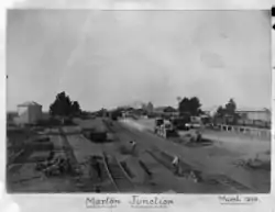 Marton Junction railway yard and station 1909 | |
 Marton | |
| Coordinates: 40°04′09″S 175°22′42″E | |
| Country | New Zealand |
| Region | Manawatū-Whanganui |
| Territorial authority | Rangitikei District |
| Named for | Marton, England |
| Government | |
| • Mayor | Andy Watson |
| • MP | Ian McKelvie |
| Elevation | 152 m (499 ft) |
| Population (June 2020)[1] | |
| • Total | 5,470 |
| Postcode(s) | 4710 |
| Area code(s) | 06 |
Ngāti Apa are tangata whenua for the Marton area.
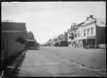
The town of Marton is the largest in the Rangitikei district, and began life as a private township in 1866, when shop and housing sections were sold at auction by local landowners.
At the time of the 2013 census, the town had 4,548 residents.[2]
Marton has always been a service town for the fertile farming region of the Manawatu Plains. Butter, wool, and flour have been among its agricultural products. The arrival of the railway in 1878 led to rapid growth in the area, which soon added industries such as engineering, sawmilling, and textile production to its economy.
History
For three years the small village was known as Tutaenui, named after the stream running through its centre. In 1869 local citizens changed the name to Marton to honour the birthplace of Captain James Cook in Middlesbrough, marking his landing in New Zealand exactly 100 years earlier. It is not known if this change of name was influenced by the mistranslation of 'tutae' (meaning 'dung') and 'nui' (meaning 'large').[3] (Actual translation: 'tu' -stand, 'tae' -arrive, 'nui' big; i.e., a 'big gathering').[4]
From the start Marton was an ideal supply centre for district farmers, who first began arriving in the early 1850s. From butter and wool they moved on to growing wheat in 1863, and big crops led to three flourmills being launched in the area in 1864.
After the town itself opened up in 1866, general stores, two hotels and several blacksmiths soon started. Marton became a home base for the horse industry, with saddlers, wheelwrights, livery stables and coachbuilders competing for business, while Clydesdale and Suffolk Punch sires toured the district to build up the population of plough horses needed as new farms sprang into being.
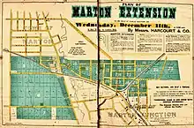
The opening of the railway line joining Wanganui to Palmerston North in 1878, now part of the North Island Main Trunk railway (towards Palmerston North and Auckland) and the Marton - New Plymouth Line (towards Wanganui), turned Marton Railway Station into a thriving railway junction, and it held that position for the next 100 years. The move of the railway station in 1898 was followed by a large development of 'Marton Extension', to the south east, from 1907.[5]
Timber from Rangitikei forests served the town's two timbermills, the first from 1889 onwards.
Industry developed quietly at first in Marton, starting with flourmilling, brickmaking and wool presses. By the late 1950s there was an incredible array of industries and factories in action. They turned out products as diverse as men's shirts, tractor safety cabs, soft drinks, vegetable salads, readymix concrete, field tiles, dog biscuits, knitwear, dried peas, electronic petrol pumps, vegetable digging machinery.
9 km from Marton was the large Lake Alice Hospital for psychiatric patients, which opened in 1950 and closed in 1999. It included a maximum security unit, and housed hundreds of patients during its 49 years of operation.
Government and politics
Local government
The current Mayor of the Rangitikei District is Andy Watson.[6] Marton is served by four ward councillors on the Rangitikei District Council; these are Cath Ash, Nigel Belsham, Dave Wilson and Lynne Sheridan.[7] All were elected at the 2016 local elections and are due for re-election in October 2019.[8]
National government
Marton is located in the general electorate of Rangitīkei and in the Māori electorate of Te Tai Hauāuru.[9] Rangitīkei is a safe National Party seat since the 1938 election with the exception of 1978–1984 when it was held by Bruce Beetham of the Social Credit Party. Since 2011 it is held by Ian McKelvie.[10]
Te Tai Hauāuru is a more volatile seat, having been held by three different parties since 1996, i.e. New Zealand First, the Māori Party and the Labour Party.[11] Since 2014 it is held by Adrian Rurawhe of the Labour Party.[12]
Education
Marton has four co-educational state primary schools for Year 1 to 8 students: Marton School,[13] with a roll of 176;[14] Marton Junction School,[15] with a roll of 83;[16] James Cook School,[17] with a roll of 206;[18] and South Makirikiri School,[19][20] with a roll of 147,[21]
There are also two other primary schools. St Matthew's School is a state-integrated Catholic primary school,[22] with a roll of 29.[23] Huntley School is a private Anglican boarding school,[24][25] with a roll of 132.[26]
Rangitikei College is a co-educational state primary school,[27][28] with a roll of 300.[29]
Nga Tawa Diocesan School is a state-integrated girls' boarding school for Year 9 to 13 students,[30][31] with a roll of 169.[32]
Until 2016 there was a third secondary schools, Turakina Māori Girls' College.[33][34]
Demographics
| Year | Pop. | ±% p.a. |
|---|---|---|
| 2001 | 4,713 | — |
| 2006 | 4,680 | −0.14% |
| 2013 | 4,548 | −0.41% |
| Source: [35][36] | ||
Marton had a population of 4,548 according to the 2013 New Zealand census. This is a decrease of 132, or 2.8 percent, since the 2006 census. There were 1,920 occupied dwellings, 198 unoccupied dwellings, and 3 dwellings under construction.[35]
Of the residential population, 2,169 (47.7%) were male compared to 48.7% nationally, and 2,376 (52.2%) were female, compared to 51.3% nationally. The town had a median age of 44.0 years, 6.0 years above the national median age of 38.0 years. People aged 65 and over made up 22.5% of the population, compared to 14.3% nationally, and people under 15 years made up 20.2%, compared to 20.4% nationally.[35]
Marton's ethnicity is made up of (national figures in brackets): 76.5% European (74.0%), 22.8% Māori (14.9%), 1.9% Asian (11.8%), 7.8% Pacific Islanders (7.4%), 0.1% Middle Eastern, Latin American or African (1.2%), and 2.0% Other (2.5%).[35]
Marton had an unemployment rate of 8.9% of people 15 years and over, compared to 7.4% nationally. The median annual income of all people 15 years and over was $21,500, compared to $28,500 nationally. Of those, 46.8% earned under $20,000, compared to 38.2% nationally, while 13.8% earned over $50,000, compared to 26.7% nationally.[35]
Transport
The nearest airports to the town are Whanganui Airport, located 37 km west, and Palmerston North Airport, located 44 km southeast. Both airports are domestic only.
Marton is on the North Island Main Trunk Line; and on the Marton-New Plymouth Line which leaves the NIMT at Marton. However although the Overlander on the NIMT used to stop at Marton railway station, the replacement Northern Explorer introduced in 2012 has fewer stops and does not stop at Marton.
Climate
Marton's climate is temperate and has few extremes compared to many parts of New Zealand. Summers are warm with average temperatures in the low 20s. The most settled weather occurs in summer and early autumn. Winters are mild and annual rainfall is moderate. Annual hours of bright sunshine can average over 2,000.[37]
| Climate data for Marton | |||||||||||||
|---|---|---|---|---|---|---|---|---|---|---|---|---|---|
| Month | Jan | Feb | Mar | Apr | May | Jun | Jul | Aug | Sep | Oct | Nov | Dec | Year |
| Average high °C (°F) | 22.1 (71.8) |
22.5 (72.5) |
20.7 (69.3) |
18.1 (64.6) |
15.1 (59.2) |
12.8 (55.0) |
12.1 (53.8) |
12.9 (55.2) |
14.5 (58.1) |
16.4 (61.5) |
18.3 (64.9) |
20.3 (68.5) |
17.2 (63.0) |
| Daily mean °C (°F) | 17.4 (63.3) |
17.7 (63.9) |
16.1 (61.0) |
13.7 (56.7) |
11.0 (51.8) |
8.9 (48.0) |
8.2 (46.8) |
8.9 (48.0) |
10.5 (50.9) |
12.3 (54.1) |
14.0 (57.2) |
15.9 (60.6) |
12.9 (55.2) |
| Average low °C (°F) | 12.8 (55.0) |
12.9 (55.2) |
11.6 (52.9) |
9.3 (48.7) |
7.0 (44.6) |
5.1 (41.2) |
4.3 (39.7) |
4.9 (40.8) |
6.6 (43.9) |
8.2 (46.8) |
9.8 (49.6) |
11.6 (52.9) |
8.7 (47.7) |
| Average rainfall mm (inches) | 79.7 (3.14) |
65.2 (2.57) |
80.4 (3.17) |
73.0 (2.87) |
92.3 (3.63) |
98.9 (3.89) |
97.2 (3.83) |
85.1 (3.35) |
80.9 (3.19) |
93.2 (3.67) |
79.0 (3.11) |
92.0 (3.62) |
1,016.9 (40.04) |
| Source 1: Climate-charts.com[38] | |||||||||||||
| Source 2: Climate-data.org[39] | |||||||||||||
Culture
Notable people
- Francis Arkwright, politician
- Bruce Beetham, Social Credit politician
- Iris Crooke, Nurse, Florence Nightingale Medal, Volunteer
- Israel Dagg, All Black
- Sir Michael Fowler, Architect, former Mayor of Wellington
- James Laurenson, actor
- Launcelot Eric Richdale, former ornithologist
- Norman Shelton, National MP
Further reading
- Melody, Paul (1981) [1979]. They called it Marton: The Life and Times of Marton, 1866-1979. Palmerston North: G.P.H. Print.
Footnotes
- "Population estimate tables - NZ.Stat". Statistics New Zealand. Retrieved 22 October 2020.
- "New Zealand Census 2013". Statistics New Zealand. Archived from the original on 15 April 2015. Retrieved 15 April 2015.
- Ngata dictionary — Learning Media Archived 2007-01-28 at the Wayback Machine
- Melody 1981, pp. 1-4.
- "MARTON EXTENSION. MANAWATU TIMES". paperspast.natlib.govt.nz. 11 Dec 1907. Retrieved 2021-01-24.
- Wallis, Anna (14 October 2013). "Watson wins Rangitikei chain". Wanganui Chronicle – nzherald.co.nz. Retrieved 1 February 2016.
- "Councillors". Rangitikei District Council. Retrieved 1 February 2016.
- "Local Electoral Act 2001". Parliamentary Counsel Office. Retrieved 18 September 2013.
- "Find my Electorate". Electoral Commission. Retrieved 1 February 2016.
- "Rangitīkei Electorate Profile". New Zealand Parliament. 30 September 2012. Retrieved 1 February 2016.
- "Te Tai Hauāuru Electorate Profile". New Zealand Parliament. 30 September 2012. Archived from the original on 10 March 2016. Retrieved 1 February 2016.
- "Rurawhe, Adrian". New Zealand Parliament. 4 December 2015. Retrieved 1 February 2016.
- "Marton School Ministry of Education School Profile". educationcounts.govt.nz. Ministry of Education.
- "Marton School Education Review Office Report". ero.govt.nz. Education Review Office.
- "Marton Junction School Ministry of Education School Profile". educationcounts.govt.nz. Ministry of Education.
- "Marton Junction School Education Review Office Report". ero.govt.nz. Education Review Office.
- "James Cook School Ministry of Education School Profile". educationcounts.govt.nz. Ministry of Education.
- "James Cook School Education Review Office Report". ero.govt.nz. Education Review Office.
- "South Makirikiri School Official School Website". southmak.school.nz.
- "South Makirikiri School Ministry of Education School Profile". educationcounts.govt.nz. Ministry of Education.
- "South Makirikiri School Education Review Office Report". ero.govt.nz. Education Review Office.
- "St Matthew's School Ministry of Education School Profile". educationcounts.govt.nz. Ministry of Education.
- "St Matthew's School Education Review Office Report". ero.govt.nz. Education Review Office.
- "Huntley School Official School Website". huntley.school.nz.
- "Huntley School Ministry of Education School Profile". educationcounts.govt.nz. Ministry of Education.
- "Huntley School Education Review Office Report". ero.govt.nz. Education Review Office.
- "Rangitikei College Official School Website". rangitikeicollege.school.nz.
- "Rangitikei College Ministry of Education School Profile". educationcounts.govt.nz. Ministry of Education.
- "Rangitikei College Education Review Office Report". ero.govt.nz. Education Review Office.
- "Nga Tawa School Official School Website". ngatawa.school.nz.
- "Nga Tawa School Ministry of Education School Profile". educationcounts.govt.nz. Ministry of Education.
- "Nga Tawa School Education Review Office Report". ero.govt.nz. Education Review Office.
- Wilkie, Kelsey (26 November 2015). "Turakina Maori Girls' College closed due to multiple failures, minister says". Stuff. Retrieved 1 February 2016.
- Wilkie, Kelsey (25 November 2015). "Turakina Maori Girls' College 'devastated' over school closure". Stuff. Retrieved 1 February 2016.
- "2013 Census tables about a place: Marton". Statistics New Zealand. Retrieved 1 February 2016.
- "1996 Census of Population and Dwellings – Census Night Population". Statistics New Zealand. 28 February 1997. Archived from the original on 13 February 2016. Retrieved 1 February 2016.
- "Weather & Climate". Rangitikei District Council. Retrieved 23 July 2016.
- "Marton Ross St., New Zealand". Climate-charts.com. Retrieved 23 July 2016.
- "Climate: Marton". Climate-data.org. Retrieved 23 July 2016.
- Walters, Laura (8 December 2011). "Marton back on the pitch". Manawatu Standard – Stuff. Retrieved 1 February 2016.
- Dennis, Jared (19 August 2006). "Marton cricket explores its options". Wanganui Chronicle – nzherald.co.nz. Retrieved 1 February 2016.
External links
| Wikimedia Commons has media related to Marton, New Zealand. |
Rangitikei District, New Zealand | |||||||||
|---|---|---|---|---|---|---|---|---|---|
| Main towns and area units | |||||||||
| Minor towns and localities |
| ||||||||
| Schools |
| ||||||||
| Electorates |
| ||||||||
| Members of Parliament |
| ||||||||
| Mayor (Council) |
| ||||||||
| Bodies of water | |||||||||
| Transportation | |||||||||
| Other | |||||||||