Matale District
Matale District (Sinhala: මාතලේ දිස්ත්රික්කය, Tamil: மாத்தளை மாவட்டம்) is a district in Central Province, Sri Lanka. It is one of 25 districts of Sri Lanka, the second level administrative division of the country. The district is administered by a District Secretariat headed by a District Secretary (previously known as a Government Agent) appointed by the central government of Sri Lanka. The administrative capital and largest city of the district is Matale.
Matale District
මාතලේ දිස්ත්රික්කය மாத்தளை மாவட்டம் | |
|---|---|
 | |
 Flag | |
 Map of Sri Lanka with Matale District highlighted | |
| Coordinates: 7°40′N 80°45′E | |
| Country | Sri Lanka |
| Province | Central Province |
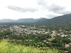
| Largest city | Matale |
| Divisions | List
|
| Government | |
| • District Secretary | S. M. G. K. Perera |
| • Local | List
|
| Area | |
| • Administrative District | 1,993 km2 (770 sq mi) |
| • Land | 1,952 km2 (754 sq mi) |
| • Water | 41 km2 (16 sq mi) |
| Population (2012)[1] | |
| • Administrative District | 484,531 |
| • Estimate (2019)[2] | 522,000 |
| • Density | 240/km2 (630/sq mi) |
| • Urban | 60,276 |
| Time zone | UTC+05:30 (Sri Lanka) |
| ISO 3166 code | LK-22 |
The district is considered as the central region of the island and has a total area of 1,993 km2 (770 sq mi). It is in the northern part of the Central Province. It is bounded to the north by Anuradapura, east by Polonnaruwa, Badulla and Ampara, west by Kurunagala and to the south by Kandy Districts.
Ethnicity and religions
Religion in Matale District (2012)[3]
Cities
- Matale (Municipal Council)
Other divisions
Heritage sites
List of other tourist attractions in Matale District
- Pitawala Pathana
- Hunnas Falls
- Sembuwatta Lake
- Riverstone
References
- Department of Census and Statistics,
- Citypopulation,
- http://www.statistics.gov.lk/PopHouSat/CPH2012Visualization/htdocs/index.php?usecase=indicator&action=DSMap&indId=10&district=Matale&Legend=3#
| Central Province | ||
|---|---|---|
| Eastern Province | ||
| North Central Province | ||
| Northern Province | ||
| North Western Province | ||
| Sabaragamuwa Province | ||
| Southern Province | ||
| Uva Province | ||
| Western Province | ||