Mattawan, Ontario
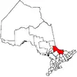
Mattawan is a township in the Canadian province of Ontario. Located in the Nipissing District, the township had a population of 161 in the Canada 2016 Census.
Mattawan | |
|---|---|
| Township of Mattawan | |
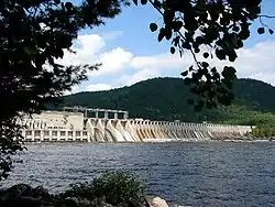
 The Otto Holden Generating Station and dam across the Ottawa River. | |
 Mattawan | |
| Coordinates: 46°20′N 78°50′W | |
| Country | Canada |
| Province | Ontario |
| District | Nipissing |
| Government | |
| • Mayor | Peter Murphy |
| Area | |
| • Land | 201.00 km2 (77.61 sq mi) |
| Population (2016)[2] | |
| • Total | 161 |
| • Density | 0.8/km2 (2/sq mi) |
| Time zone | UTC-5 (Eastern (EST)) |
| Postal code | P0H 1V0 |
| Area code(s) | 705 |
| Website | Town of Mattawan |
The township has no named communities within its boundaries; all addresses within the township are rural routes assigned to the neighbouring town of Mattawa.
Its main access road is Highway 533, with Highway 656 as a short branch leading to the Otto Holden Generating Station on the Ottawa River.
In 2007, Mattawan, along with the town of Mattawa and the townships of Papineau-Cameron, Bonfield and Calvin cooperated to create a newly branded Mattawa Voyageur Country tourist region in order to promote the area.[3]
Demographics
| Canada census – Mattawan, Ontario community profile | |||
|---|---|---|---|
| 2016 | 2011 | 2006 | |
| Population: | 161 (-0.6% from 2011) | 162 (+10.2% from 2006) | 147 (+28.9% from 2001) |
| Land area: | 201.00 km2 (77.61 sq mi) | 200.96 km2 (77.59 sq mi) | 199.52 km2 (77.04 sq mi) |
| Population density: | 0.8/km2 (2.1/sq mi) | 0.8/km2 (2.1/sq mi) | 0.7/km2 (1.8/sq mi) |
| Median age: | 53.9 (M: 55.4, F: 53.5) | 48.2 (M: 47.8, F: 49.0) | |
| Total private dwellings: | 104 | 99 | 120 |
| Median household income: | $77,312 | ||
| References: 2016[4] 2011[5] 2006[6] earlier[7] | |||
Mother tongue:
- English as first language: 90%
- French as first language: 10%
- English and French as first language: 0%
- Other as first language: 0%
| Year | Pop. | ±% |
|---|---|---|
| 1991 | 127 | — |
| 1996 | 115 | −9.4% |
| 2001 | 114 | −0.9% |
| 2006 | 147 | +28.9% |
| 2011 | 162 | +10.2% |
| 2016 | 161 | −0.6% |
| [8][1][2] | ||
References
- "Mattawan census profile". 2011 Census of Population. Statistics Canada. Retrieved 2012-02-09.
- "Census Profile, 2016 Census: Mattawan, Township". Statistics Canada. Retrieved June 24, 2019.
- Adams, K. "Mattawa sports a new look", Baytoday.ca, July 17, 2007. Accessed March 28, 2008.
- "2016 Community Profiles". 2016 Canadian Census. Statistics Canada. February 21, 2017. Retrieved 2019-06-24.
- "2011 Community Profiles". 2011 Canadian Census. Statistics Canada. July 5, 2013. Retrieved 2012-02-09.
- "2006 Community Profiles". 2006 Canadian Census. Statistics Canada. March 30, 2011. Retrieved 2012-02-09.
- "2001 Community Profiles". 2001 Canadian Census. Statistics Canada. February 17, 2012.
- Statistics Canada: 1996, 2001, 2006 census
External links
This article is issued from Wikipedia. The text is licensed under Creative Commons - Attribution - Sharealike. Additional terms may apply for the media files.

