South Algonquin
South Algonquin is a township municipality[1] in Nipissing District, Ontario, Canada.[1][3][4][5][6] Located south of Algonquin Provincial Park, it is the sole populated portion of the district that lies south of the traditional dividing line between Northern Ontario and Southern Ontario and is closer connected to Renfrew County as opposed to the core portions of Nipissing District.
South Algonquin | |
|---|---|
| Township of South Algonquin | |
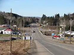 Highway 60 in Whitney | |
 South Algonquin Location on a map of Southern Ontario | |
| Coordinates: 45°29′48″N 78°01′26″W[1] | |
| Country | Canada |
| Province | Ontario |
| District | Nipissing |
| Incorporated | October 1961 |
| Government | |
| • Type | Township |
| • Mayor | Jane Dumas |
| • Governing body | South Algonquin Township Council |
| • Councillors | List
|
| • Federal riding | Renfrew—Nipissing—Pembroke |
| • Prov. riding | Renfrew—Nipissing—Pembroke |
| Area | |
| • Total | 873.43 km2 (337.23 sq mi) |
| Population (2016)[2] | |
| • Total | 1,096 |
| • Density | 1.3/km2 (3/sq mi) |
| Time zone | UTC-5 (EST) |
| • Summer (DST) | UTC-4 (EDT) |
| Postal code | K0J 2M0 |
| Area code(s) | 613, 343 |
| Website | www |
The township had a population of 1,096 in the Canada 2016 Census.[2]
Communities and geographic townships
The communities of Aylen Lake, Cross Lake, Gunters, Madawaska, McKenzie Lake,[7] Murchison, Opeongo, Wallace and Whitney are in South Algonquin.[4][5] It also includes the geographic townships of Airy, Dickens, Lyell, Murchison, and Sabine, with the exception of a triangle, the northwest corner, of Airy Township that is part of Algonquin Provincial Park.[1][4]
History
The area was settled primarily as the site for the sawmill of the St. Anthony Lumber Company, of Minnesota, and is named for the general manager of that firm, Edwin Canfield Whitney. Whitney, who was born near Morrisburg, Ontario, had moved to the Midwestern United States shortly after the Civil War. Working in the lumber trade, he became manager of the St. Anthony Lumber Company in Minneapolis.
By 1892 work had commenced on the Ottawa, Arnprior and Parry Sound Railway (later the Canada Atlantic Railway), by Ottawa lumberman John Rudolphus Booth. Booth's sawmill at the Chaudière Falls in Ottawa, was considered to be one of the largest in North America, second only to a mill in Minneapolis. At the end of 1892, Booth arranged a takeover of the adjacent Perley and Pattee mill, from the estate of his former colleague William Goodhue Perley.
Timber berths on the upper Madawaska River, in the townships of Airy and Nightingale, belonging to the Perley & Pattee Lumber Company, were sold in 1894, to the St. Anthony Lumber Company, of Minneapolis. As the OA&PS Railway was being constructed to access this area, Whitney persuaded the management of the St. Anthony firm to purchase the timber berths.
About a year after the Whitney sawmill was built, Fowler and Hill sold the Minneapolis mill and associated timber limits to Frederick Weyerhaeuser of St. Paul. Whitney who had large timber holdings near Brainerd, Minnesota, sold these to Weyerhaeuser as well, making enough profit that he was able to purchase his partners' interests in the Whitney concern and continue its operation on his own.
The Canadian National Railway Renfrew Subdivision was abandoned between Whitney and Renfrew in 1983.
Natural history
Opeongo River Provincial Park and Upper Madawaska River Provincial Park are in South Algonquin.[4][5]
Demographics
| Canada census – South Algonquin community profile | |||
|---|---|---|---|
| 2016 | 2011 | 2006 | |
| Population: | 1096 (-9.5% from 2011) | 1211 (-3.4% from 2006) | 1253 (-2.0% from 2001) |
| Land area: | 873.43 km2 (337.23 sq mi) | 872.49 km2 (336.87 sq mi) | 871.31 km2 (336.41 sq mi) |
| Population density: | 1.3/km2 (3.4/sq mi) | 1.4/km2 (3.6/sq mi) | 1.4/km2 (3.6/sq mi) |
| Median age: | 56.2 (M: 56.1, F: 56.2) | 49.4 (M: 48.4, F: 50.7) | |
| Total private dwellings: | 855 | 977 | 1201 |
| Median household income: | $49,427 | ||
| References: 2016[2] 2011[8] 2006[9] earlier[10] | |||
See also
References
- "South Algonquin". Geographical Names Data Base. Natural Resources Canada. Retrieved 2018-08-30.
- "2016 Community Profiles". 2016 Canadian Census. Statistics Canada. February 21, 2017. Retrieved 2018-08-31.
- "Toporama (on-line map and search)". Atlas of Canada. Natural Resources Canada. Retrieved 2018-08-30.
- "Ontario Geonames GIS (on-line map and search)". Ontario Ministry of Natural Resources and Forestry. 2014. Retrieved 2018-08-30.
- Map 9 (PDF) (Map). 1 : 1,600,000. Official road map of Ontario. Ministry of Transportation of Ontario. 2018-01-01. Retrieved 2018-08-30.
- Restructured municipalities - Ontario map #5 (Map). Restructuring Maps of Ontario. Ontario Ministry of Municipal Affairs and Housing. 2006. Retrieved 2018-08-30.
- "McKenzie Lake". Geographical Names Data Base. Natural Resources Canada. Retrieved 2020-06-03.
- "2011 Community Profiles". 2011 Canadian Census. Statistics Canada. July 5, 2013. Retrieved 2012-02-13.
- "2006 Community Profiles". 2006 Canadian Census. Statistics Canada. March 30, 2011. Retrieved 2012-02-13.
- "2001 Community Profiles". 2001 Canadian Census. Statistics Canada. February 17, 2012.
External links
| Wikimedia Commons has media related to South Algonquin. |
Places adjacent to South Algonquin | |
|---|---|
| Cities | 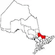 | |
|---|---|---|
| Towns | ||
| Townships | ||
| First Nations | ||
| Indian reserves | ||
| Unorganized areas | ||
| Local services boards | ||
| ||