Melbourne tram route 30
Melbourne tram route 30 is operated by Yarra Trams on the Melbourne tram network. It operates from St Vincent's Plaza to Docklands Central Pier. The 2.9 kilometre route is operated by A class trams from Southbank depot.[1][2]
| Route 30 | |||
|---|---|---|---|
| St Vincent's Plaza - Central Pier | |||
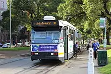
 A class tram on Victoria Parade on route 30 in April 2013 | |||
| Overview | |||
| System | Melbourne tramway network | ||
| Operator | Yarra Trams | ||
| Depot | Southbank | ||
| Vehicle | A class | ||
| Began service | 25 September 1972 | ||
| Route | |||
| Length | 2.9 km (1.8 mi) | ||
| Timetable | Route 30 timetable | ||
| Map | Route 30 map | ||
| |||
History
Route 30 was first allocated to the line between City (Spencer St) to Brunswick Street (St Vincent's Plaza) via La Trobe Street on 25 September 1972. Prior to that, trams running the La Trobe Street shuttle usually ran without numbers.[3] Most of the trams routes that ran via Brunswick Street or Victoria Parade also had peak-hour variants that would terminate at the La Trobe Street (for example Route 23 and 24). For most of its operation, Route 30 had never had an weekend or an evening service (services ending at 6pm). In 1995, Route 34 commenced operation between City (La Trobe Street) and East Melbourne, and operated during off-peak hours (10:00am to 3:30pm).[4] Route 30 became peak-only following this point. Route 34 was discontinued from regular service on 19 September 2003, and Route 30 began operating off-peak again.[5] On 4 January 2005, Route 30 was extended to Waterfront City along Harbour Esplanade and Docklands Drive, with the opening of the Docklands Drive tram extension.[6] Route 30 started terminating in its current location in Harbour Esplanade at Central Pier in July 2008, with route 86 being extended to Waterfront City.[5][7]
The line along La Trobe Street between Spencer Street (Stop 1) and St Vincent's Plaza (Stop 12) was opened by the Melbourne & Metropolitan Tramways Board on 15 January 1951. On 19 June 1973, a siding was installed just east of St. Vincent's Plaza in order to allow Route 12 and Route 30 trams to shunt out of the way of through-running trams.[3] As part of the Docklands redevelopment project, tram tracks along La Trobe Street were extended west over the Spencer Street railyards on 26 March 2000. On 4 January 2005, the Docklands Drive tram extension opened. Route 30 initially terminated at Waterfront City following this point, but swapped termini with Route 86 on 28 July 2008.[5]
On January 1, 2019, the operation of Route 30 was extended to evenings & weekends for the first time.
| Dates | Route | Notes |
|---|---|---|
| 25 September 1972 - 3 January 2005 | City (La Trobe Street) to City (Brunswick Street) | Route operated without number prior to this date; Never an evening service |
| 4 January 2005 - 27 July 2008 | Waterfront City Docklands to City (Brunswick Street) | No evening service |
| 28 July 2008 – Present | Central Pier Docklands to City (Brunswick Street) | No evening service |
Route
Route 30 runs from the St Vincent's Plaza interchange, East Melbourne west on Victoria Parade passing St Vincent's Hospital, Eye & Ear Hospital and the Royal Exhibition Building in the Carlton Gardens. It turns into La Trobe Street and continues west passing Royal Melbourne Institute of Technology, State Library of Victoria, Melbourne Central railway station, Flagstaff Gardens and Flagstaff railway station, crossing into Docklands, passing Docklands Stadium and turning south into Harbour Esplanade where it terminates at Central Pier.
Operation
Route 30 is operated by Southbank depot with A class trams.[2] It was operated by W class trams until 23 December 2014.
Until January 2019, Route 30 was the only tram route on the network that neither operated at night nor on weekends.
Map
References
- Facts & figures Archived 29 May 2014 at the Wayback Machine Yarra Trams
- Route 30 Yarra Trams
- "Gunzel". www.classicaustraliantv.com. Retrieved 22 August 2018.
- "Melways". University of Melbourne.
- History of Melbourne Trams Routes from 1950 to 2009 Archived 26 February 2017 at the Wayback Machine Yarra Trams
- "Docklands Drive Tram Extension Now In Service", Yarra Trams, retrieved 28 September 2011
- "Completed tram initiatives", Department of Transport, retrieved 28 September 2011
External links
 Media related to Melbourne tram route 30 at Wikimedia Commons
- Route 30 timetable and map