Meppel
Meppel (Dutch pronunciation: [ˈmɛpəl] (![]() listen)) is a municipality and a city in the northeast of the Netherlands, in the south-west of the province Drenthe.
listen)) is a municipality and a city in the northeast of the Netherlands, in the south-west of the province Drenthe.
Meppel | |
|---|---|
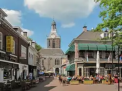 Meppeler toren (Tower of Meppel) | |
 Flag Coat of arms | |
.svg.png.webp) Location in Drenthe | |
| Coordinates: 52°42′N 6°11′E | |
| Country | Netherlands |
| Province | Drenthe |
| Government | |
| • Body | Municipal council |
| • Mayor | Richard Korteland (VVD) |
| Area | |
| • Total | 57.03 km2 (22.02 sq mi) |
| • Land | 55.53 km2 (21.44 sq mi) |
| • Water | 1.50 km2 (0.58 sq mi) |
| Elevation | 2 m (7 ft) |
| Population (January 2019)[4] | |
| • Total | 33,564 |
| • Density | 604/km2 (1,560/sq mi) |
| Demonym(s) | Meppeler |
| Time zone | UTC+1 (CET) |
| • Summer (DST) | UTC+2 (CEST) |
| Postcode | 7940–7949, 7965–7969 |
| Area code | 0522 |
| Website | www |
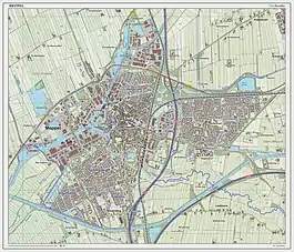
Meppel is the smallest municipality in the province of Drenthe, with a total area of 58 km².
People born in Meppel are occasionally referred to as 'Meppeler Muggen';[5] this translates as mosquitos/gnats from Meppel. This is due to a traditional folk tale. The people of Meppel thought the church tower was on fire. After closer inspection it was only a swarm of mosquitos.[6]
History
It developed in the 16th century as an inland harbour for peat transport and distribution. There used to be a lot of waterways in the town, but now only one remains. Meppel received city rights in 1644.
Geography
Meppel is located at 52°42′N 6°11′E in the south-west of the province of Drenthe in the east of the Netherlands.
The Meppelerdiep, the Drentsche Hoofdvaart and the Hoogeveense Vaart connect Meppel to Zwartsluis, Assen and Hoogeveen. To offload professional transport vessels the Omgelegde Hoogeveense Vaart was dug out south of the city. The Meppelerdiep is accessible for boats with a size of 2000 ton.
The streams Reest and Wold Aa run through the city. The Reest end in the Meppeler Diep.
The population centres in the municipality are:
- Nijeveen
- Nijentap
- Part of Havelterberg
- Broekhuizen
- Rogat
- De Schiphorst
Transportation
Meppel is served by train connections with Zwolle to the south, which leads to the rest of the country, and Leeuwarden and Groningen to the north and north-east.
There are regular and frequent bus lines within Meppel and towards Zwolle, Hoogeveen and Assen. The bus station is situated in front of the classic railway station.
By car, the town is accessible via the A28 motorway (Netherlands) towards Zwolle in the south and Groningen to the north-east, A32 motorway (Netherlands) (that begins at the motorway crossing Lankhorst south of the city) towards Leeuwarden in the north.
Notable people

.jpg.webp)
- Jan Jansen Bleecker (1641—1732) merchant and political figure, Mayor of Albany, New York
- Arent Magnin (1825–1888) a Dutch politician in the administration on the Dutch Gold Coast
- Petrus Johannes Waardenburg (1886 in Nijeveen – 1979) a Dutch ophthalmologist and geneticist; Waardenburg syndrome is named after him
- Ben Nijboer (1915–1999) a Dutch physicist and academic in optics and solid-state physics
- Louise Fresco (born 1952) a Dutch scientist and writer on globally sustainable food production
- Catrien Santing (born 1958) a Dutch medievalist
- Erik Kwakkel (born 1970) a Dutch scholar who specializes in medieval manuscripts, paleography, and codicology
- Albert van der Haar (born 1975) is a Dutch former footballer with almost 500 club caps
The Arts
- Petrus Kiers (1807–1875) a Dutch painter, graphic artist and photographer
- Sir Joseph Joel Duveen (1843–1908) an art dealer and benefactor of art galleries [7]
- Henry J. Duveen (1854–1919) an art dealer
- Eduard Frankfort (1864–1920) a Dutch Jewish painter
- Jan Mankes (1889–1920) a Dutch painter, sometimes categorized as a symbolic realist
- Jelle Taeke de Boer (1908–1970) a Dutch art collector
- Roelof Frankot (1911–1984) a Dutch painter, a strong relation with the CoBrA movement
Photo gallery
 Square in town centre
 City Hall
 Windmill (molen de Weert)
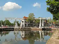 Two drawbridges
 Ship the Vereeniging III
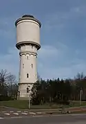 Watertower
 Historical Centre of Meppel
References
- "Richard Korteland" (in Dutch). Gemeente Meppel. Retrieved 9 October 2013.
- "Kerncijfers wijken en buurten 2020" [Key figures for neighbourhoods 2020]. StatLine (in Dutch). CBS. 24 July 2020. Retrieved 19 September 2020.
- "Postcodetool for 7941BJ". Actueel Hoogtebestand Nederland (in Dutch). Het Waterschapshuis. Archived from the original on 21 September 2013. Retrieved 9 October 2013.
- "Bevolkingsontwikkeling; regio per maand" [Population growth; regions per month]. CBS Statline (in Dutch). CBS. 1 January 2019. Retrieved 1 January 2019.
- "CBOEK363 - EENIGE SCHELDNAMEN VAN DE EENE PLAATS OP DE ANDERE". Nederlandse Volksverhalenbank. Archived from the original on 28 April 2017. Retrieved 28 April 2017.
- "De toren". Vrienden van de Grote of Mariakerk. Archived from the original on 30 December 2016. Retrieved 28 April 2017.
- Dictionary of National Biography, 1912 supplement, Duveen, Joseph Joel retrieved 17 November 2019
External links
| Wikivoyage has a travel guide for Meppel. |
Places adjacent to Meppel | ||||||||||
|---|---|---|---|---|---|---|---|---|---|---|
| ||||||||||
Municipalities of Drenthe | ||
|---|---|---|
 | ||
| ||
| Authority control |
|---|