Mesves-sur-Loire
Mesves-sur-Loire is a commune in the Nièvre department in central France.[3]
Mesves-sur-Loire | |
|---|---|
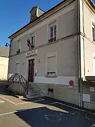 The City Hall | |
Location of Mesves-sur-Loire 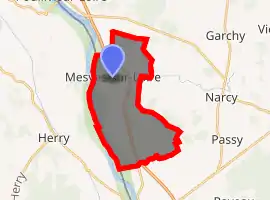
| |
 Mesves-sur-Loire  Mesves-sur-Loire | |
| Coordinates: 47°14′39″N 2°59′38″E | |
| Country | France |
| Region | Bourgogne-Franche-Comté |
| Department | Nièvre |
| Arrondissement | Cosne-Cours-sur-Loire |
| Canton | Pouilly-sur-Loire |
| Intercommunality | Loire et Vignoble |
| Government | |
| • Mayor (2020–2026) | Bernard Gilot[1] |
| Area 1 | 18.64 km2 (7.20 sq mi) |
| Population (2017-01-01)[2] | 690 |
| • Density | 37/km2 (96/sq mi) |
| Time zone | UTC+01:00 (CET) |
| • Summer (DST) | UTC+02:00 (CEST) |
| INSEE/Postal code | 58164 /58400 |
| Elevation | 148–188 m (486–617 ft) |
| 1 French Land Register data, which excludes lakes, ponds, glaciers > 1 km2 (0.386 sq mi or 247 acres) and river estuaries. | |
History
In 1918, during World War I, a field between the towns of Mesves-sur-Loire and Bulcy was the site of a huge American Army hospital.[4] In November, 1918, there were 20,186 patients and a total of 38,765 wounded and convalescing soldiers spent time at this temporary hospital. As many as 140,000 Americans were stationed in the area in 1918 so the it had a major American presence.
This site, close to the Loire River, was one of two huge American Army hospitals during World War I (the other being in Mars-sur-Allier). It was selected because it was a safe distance from the battle lines in northeast France (Mesves is about 200 km south of Paris); further, it is located on a major rail line to Paris, making it accessible).
Today, Mesves-sur-Loire is a farm town surrounded by grain fields to the east (where the hospital used to be located) and vineyards to the north and south. The vineyards are within the Pouilly Fumé district, the famous wine town of Pouilly-sur-Loire being located just 5 km to the north. The general area is known as La Nièvre and lies within the larger region known as Bourgogne-Franche-Comté.
There are numerous passenger trains running to and from Paris along the rail line with the closest stop being in the medieval town of La Charité, just 8 km to the south. There is also a new highway, A-77, which parallels the rail line and runs to the outskirts of Paris. So, while Mesves is quiet, it is easily accessible from Paris.
When entering Bulcy, just 3 km to the east of Mesves, the street sign identifies the street name as rue du Camp-Américain. That is the only visible signage reminding one of the huge US Army hospital that served so many wounded service men during World War I. The fields have been totally restored and are full of crops during the growing season.
Demographics
At the 1999 census, the population was 547. On 1 January 2017, the estimate was 690.
See also
References
- "Répertoire national des élus: les maires". data.gouv.fr, Plateforme ouverte des données publiques françaises (in French). 2 December 2020. Retrieved 7 December 2020.
- "Populations légales 2017". INSEE. Retrieved 6 January 2020.
- INSEE commune file.
- Le Camp hôpital américain de Mesves-Bulcy by Francois Torcol (in French), Les Annales des Pays Nivernais (ISSN 0153-7121), ZI des Chamonds, PB 40017, 58641 Varenne-Vauzelles Cedex, 2008.
| Wikimedia Commons has media related to Mesves-sur-Loire. |
| Authority control |
|---|