Fours, Nièvre
Fours is a commune in the Nièvre department in central France.
Fours | |
|---|---|
_1.jpg.webp) The centre of Fours | |
Location of Fours 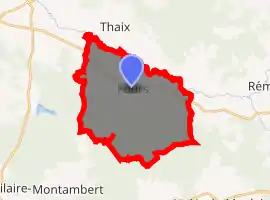
| |
 Fours  Fours | |
| Coordinates: 46°49′05″N 3°43′13″E | |
| Country | France |
| Region | Bourgogne-Franche-Comté |
| Department | Nièvre |
| Arrondissement | Château-Chinon (Ville) |
| Canton | Luzy |
| Government | |
| • Mayor (2001–2008) | Georges Pereira |
| Area 1 | 25.53 km2 (9.86 sq mi) |
| Population (2017-01-01)[1] | 645 |
| • Density | 25/km2 (65/sq mi) |
| Time zone | UTC+01:00 (CET) |
| • Summer (DST) | UTC+02:00 (CEST) |
| INSEE/Postal code | 58118 /58250 |
| Elevation | 201–263 m (659–863 ft) |
| 1 French Land Register data, which excludes lakes, ponds, glaciers > 1 km2 (0.386 sq mi or 247 acres) and river estuaries. | |
Geography
The river Alène forms all of the commune's northern border.
Demographics
At the 1999 census, the population was 780. On 1 January 2007, the estimate was 758.
See also
References
- "Populations légales 2017". INSEE. Retrieved 6 January 2020.
| Wikimedia Commons has media related to Fours (Nièvre). |
| Authority control |
|---|
This article is issued from Wikipedia. The text is licensed under Creative Commons - Attribution - Sharealike. Additional terms may apply for the media files.