Saint-Pierre-le-Moûtier
Saint-Pierre-le-Moûtier is a commune in the Nièvre department in central France. It was besieged during the Hundred Years' War.
Saint-Pierre-le-Moûtier | |
|---|---|
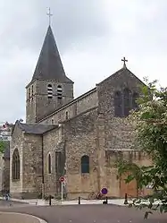 The church in Saint-Pierre-le-Moûtier | |
 Coat of arms | |
Location of Saint-Pierre-le-Moûtier 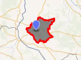
| |
 Saint-Pierre-le-Moûtier  Saint-Pierre-le-Moûtier | |
| Coordinates: 46°47′30″N 3°07′08″E | |
| Country | France |
| Region | Bourgogne-Franche-Comté |
| Department | Nièvre |
| Arrondissement | Nevers |
| Canton | Saint-Pierre-le-Moûtier |
| Intercommunality | Nivernais Bourbonnais |
| Area 1 | 47.67 km2 (18.41 sq mi) |
| Population (2017-01-01)[1] | 1,956 |
| • Density | 41/km2 (110/sq mi) |
| Time zone | UTC+01:00 (CET) |
| • Summer (DST) | UTC+02:00 (CEST) |
| INSEE/Postal code | 58264 /58240 |
| Elevation | 188–264 m (617–866 ft) |
| 1 French Land Register data, which excludes lakes, ponds, glaciers > 1 km2 (0.386 sq mi or 247 acres) and river estuaries. | |
Located between the Loire and Allier, the town has a rich and powerful history, but is a little forgotten today because of its "relative" road isolation and lack of tourist infrastructure. Saint-Pierre-le-Moûtier is close to Magny-Cours and its racing circuit which hosted the Grand Prix de France Formula 1 from 1991 to 2008.
History
On November 4, 1422 the bailiwick of Saint-Pierre rendered a sentence, compelling the inhabitants of the land of Poussery at the end of Montaron to ensure the lookout and guard at the castle Poussery, as requested by the lord of the place: Gaucher Courvol. This bailiwick rendered to the son of the latter, Philibert de Courvol, another sentence on the 25th of March, 1451, authorizing him to pass the Ruaux stream in his meadow of Chaulgy.[2]
The city is stormed, then released by Joan of Arc on November 4, 1429.[3]
It was chief town of district from 1790 to 1795.
During the revolutionary period of the National Convention (1792-1795), the municipality provisionally bore the names of Brutus-la-Vallée, Brutus-le-Magnanime and Brutus-le-Moutier.[4]
Population
In 2017, the municipality had 1,956 inhabitants a decrease of 1.6% from 2007.
| Year | Pop. | ±% p.a. |
|---|---|---|
| 1968 | 2,227 | — |
| 1975 | 2,250 | +0.15% |
| 1982 | 2,261 | +0.07% |
| 1990 | 2,091 | −0.97% |
| 1999 | 2,029 | −0.33% |
| 2007 | 1,988 | −0.25% |
| 2012 | 2,030 | +0.42% |
| 2017 | 1,956 | −0.74% |
| Source: INSEE[5] | ||
See also
References
- "Populations légales 2017". INSEE. Retrieved 6 January 2020.
- Abbé Jacques-François Baudiau, Le Morvand, vol. 3, vol.1, (Nevers, Guénégaud, 1965), 3éd.. p572.
- Nicolas Martin, La France fortifiée : Châteaux, villes et places fortes, (Paris, Nathan, 1990) (ISBN 2-09-284371-0). p146.
- Des villages de Cassini aux communes d'aujourd'hui, « Notice communale - Saint-Pierre-le-Moûtier, sur EHESS, École des hautes études en sciences sociales (consulté le 5 août 2012).
- Population en historique depuis 1968, INSEE
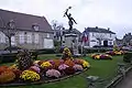 Statue of Jeanne d'Arc
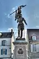 Statue of Jeanne d'Arc
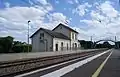 railway station
| Wikimedia Commons has media related to Saint-Pierre-le-Moûtier. |
| Authority control |
|---|