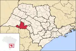
Microregion of Assis
The Microregion of Assis (Portuguese: Microrregião de Assis) is located on the west of São Paulo state, Brazil, and is made up of 17 municipalities and it belongs to the Mesoregion of Assis.
Microregion of Assis | |
|---|---|
 Location of the Microregion of Assis | |
| Country | |
| Region | Southeast |
| State | |
| Mesoregion | Assis |
| Area | |
| • Total | 7,141.738 km2 (2,757.440 sq mi) |
| Population (2014/IBGE) | |
| • Total | 278.220 |
| • Density | 0.039/km2 (0.10/sq mi) |
| Estimative | |
| Time zone | UTC-3 (UTC-3) |
| • Summer (DST) | UTC-2 (UTC-2) |
| Area code(s) | +55 18 |
The population of the Microregion is 278.220 inhabitants, in an area of 7.141,738 km²[1]
Municipalities
The microregion consists of the following municipalities,[2] listed below with their 2014 Census populations (IBGE/2014):[3]
- Assis 100.911
- Paraguaçu Paulista 44.555
- Cândido Mota 31.063
- Palmital 22.041
- Tarumã 14.027
- Maracaí 13.878
- Quatá 13.603
- Iepê 8.002
- Ibirarema 7.290
- Campos Novos Paulista 4.808
- Platina 3.406
- Pedrinhas Paulista 3.062
- Nantes 2.943
- Florínea 2.821
- Lutécia 2.741
- Cruzália 2.234
- Borá 835
References
- "2010 Census of the IBGE - Synopsis - Tables 761 and 1301" (in Portuguese). IBGE.gov.br. Retrieved 22 July 2011.
- Instituto Brasileiro de Geografia e Estatística, territorial division.
- "2010 Census of the IBGE - Population - Table 2.1.20" (PDF). IBGE.gov.br. Retrieved 20 June 2013.
This article is issued from Wikipedia. The text is licensed under Creative Commons - Attribution - Sharealike. Additional terms may apply for the media files.