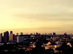
Franca
Franca is a municipality in the Brazilian state of São Paulo. The population is 355,901 (2020 est.) in an area of 606 km2.[2] Its elevation is 1140 m. It was established in 1805 as a parish within the municipality of Moji Mirim, and became an independent municipality in 1824.[3]
Franca | |
|---|---|
 | |
 Flag  Coat of arms | |
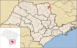 Location in São Paulo state | |
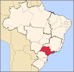
 Franca Location in Brazil | |
| Coordinates: 20°32′20″S 47°24′3″W | |
| Country | Brazil |
| Region | Southeast |
| State | São Paulo |
| Government | |
| • Mayor | Gilson de Souza (DEM) |
| Area | |
| • Municipality | 606 km2 (234 sq mi) |
| • Metro | 3,439.78 km2 (1,328.11 sq mi) |
| Elevation | 1,040 m (3,410 ft) |
| Population (2020 [1]) | |
| • Municipality | 355,901 |
| • Density | 590/km2 (1,500/sq mi) |
| • Metro | 483,383 |
| Time zone | UTC-03:00 (BRT) |
| • Summer (DST) | UTC-02:00 (BRST) |
| Postal code | 14400-000 |
| Area code | +55 16 |
| Website | www |
History
The history of the region of Franca begins at the time of the Bandeirantes explorers. The bandeira or entrada of Anhangüera (the son) in 1722 established the "way of Goiás," a trail from São Paulo to the gold mines in Goiás. Along this and other trails settlements were made, becoming the so-called "landings" or way-stations for the gold seekers. Franca was known at the time of the Bandeirantes as the "catfish landing."
At the end of the 18th century, settlers had dispersed into the region in several of these landings. In 1779, around 1000 people lived in the area around Franca . To better organize the settlement, a Decree Company was created and the Portuguese Captain Manoel de Almeida was put in charge. At the beginning of the 19th century, the sons of Manoel de Almeida (Antonio Antunes de Almeida and Vicente Ferreira de Almeida) donated lands for the construction of a chapel, which in turn was blessed by the priest Joaquin Martins Rodrigues. With the decline of mining activity in Minas Gerais and Goiás, more settlers migrated to the "Belo Sertão do Rio Pardo" (beautiful valley of the Pardo River), under the sponsorship of the governador of São Paulo, Antônio José de Franca e Horta, after whom the municipality are named.
In 1816 the "village of Franca" was officially founded by King João VI. In 1821, Minas Gerais attempted to annex the region, but due to local resistance, the attempt failed. The city motto stems from this time. The city's name was changed to "Vila Franca do Imperador", but it was shortened afterwards to "Franca".
With the expansion of coffee plantations throughout northeastern São Paulo state, many immigrants, mainly Italian, arrived in Franca. From the knowledge and hard work of these immigrants, the city's first industry, shoe manufacturing, was developed in the 1920s.
Franca took part in the Constitutionalist Revolution of 1932, in which six of her citizens died for São Paulo.
The city is now distinguished as an important center for the Brazilian footwear industry, although coffee continues today as one of the main sources of the city's revenues.
Geography
Franca is located in the northeastern region of the state of São Paulo. It is the center of the state's 14th administrative region. The municipality of Franca borders Batatais, Cristais Paulista, and Patrocínio Paulista in São Paulo state, and Ibiraci and Claraval in Minas Gerais state. The climate of the city is subtropical highland (Cwb, according to the Köppen climate classification), with dry winters and wet summers, with rains from October to March. The temperatures are mild throughout the year. In hydrography, Franca is in the Canoas River basin, and this river provides the water supply of the city.
Franca has a considerably high terrain, with an altitude of about 1,040 m above sea level. Local soils are sandy, and the vegetation is dominated by grasslands. Forests are restricted to hilly slopes.
The city is served by Ten. Lund Presotto Airport.
Climate
Franca has a tropical savanna climate, with milder temperatures due to the elevation of the city. Summers are warm and humid and winters are mild and dry.
| Climate data for Franca, elevation: 1,040 m or 3,410 ft, 1981-2010 normals and extremes | |||||||||||||
|---|---|---|---|---|---|---|---|---|---|---|---|---|---|
| Month | Jan | Feb | Mar | Apr | May | Jun | Jul | Aug | Sep | Oct | Nov | Dec | Year |
| Record high °C (°F) | 35.3 (95.5) |
34.4 (93.9) |
33.4 (92.1) |
31.9 (89.4) |
30.2 (86.4) |
30.0 (86.0) |
30.0 (86.0) |
33.7 (92.7) |
36.6 (97.9) |
37.8 (100.0) |
35.2 (95.4) |
34.0 (93.2) |
37.8 (100.0) |
| Average high °C (°F) | 27.0 (80.6) |
27.5 (81.5) |
27.2 (81.0) |
26.4 (79.5) |
24.5 (76.1) |
23.9 (75.0) |
24.3 (75.7) |
26.3 (79.3) |
27.4 (81.3) |
27.9 (82.2) |
27.4 (81.3) |
26.9 (80.4) |
26.4 (79.5) |
| Daily mean °C (°F) | 22.2 (72.0) |
22.4 (72.3) |
22.2 (72.0) |
21.3 (70.3) |
19.0 (66.2) |
18.2 (64.8) |
18.3 (64.9) |
20.2 (68.4) |
21.2 (70.2) |
22.2 (72.0) |
22.1 (71.8) |
22.0 (71.6) |
20.9 (69.7) |
| Average low °C (°F) | 18.8 (65.8) |
18.9 (66.0) |
18.7 (65.7) |
17.5 (63.5) |
15.2 (59.4) |
14.1 (57.4) |
13.9 (57.0) |
15.4 (59.7) |
16.5 (61.7) |
17.6 (63.7) |
18.1 (64.6) |
18.4 (65.1) |
16.9 (62.5) |
| Record low °C (°F) | 9.6 (49.3) |
10.0 (50.0) |
10.9 (51.6) |
4.7 (40.5) |
3.3 (37.9) |
0.0 (32.0) |
0.0 (32.0) |
1.2 (34.2) |
3.6 (38.5) |
4.8 (40.6) |
9.0 (48.2) |
10.4 (50.7) |
0.0 (32.0) |
| Average rainfall mm (inches) | 323.2 (12.72) |
243.8 (9.60) |
207.5 (8.17) |
77.7 (3.06) |
57.5 (2.26) |
17.9 (0.70) |
18.4 (0.72) |
21.6 (0.85) |
67.2 (2.65) |
161.4 (6.35) |
189.0 (7.44) |
287.4 (11.31) |
1,672.6 (65.83) |
| Average rainy days (≥ 0.1 mm) | 18 | 15 | 14 | 7 | 5 | 2 | 2 | 2 | 6 | 10 | 12 | 17 | 110 |
| Average relative humidity (%) | 79.7 | 77.6 | 77.8 | 73.2 | 70.4 | 65.9 | 58.7 | 53.4 | 58.8 | 65.7 | 72.6 | 78.7 | 69.4 |
| Mean monthly sunshine hours | 142.3 | 151.1 | 183.8 | 221.8 | 232.6 | 238.9 | 257.2 | 253.7 | 200.3 | 190.7 | 175.4 | 152.5 | 2,400.3 |
| Source: Instituto Nacional de Meteorologia (INMET) (1981-2010; temperature records since 1931)[4][5][6] | |||||||||||||
Demography
- Total: 318.785[7] inhabitants on 2010 Census (IBGE).
- Urban: 313.128
- Rural: 5.657
- Demographic density (inhabitants/km2): 473,80
- Child mortality until 1 year (in 1000): 12,66 = 1,26%
- Life expectancy (years): 73,03
- Fertility (children per women): 2,26
- Literacy: 96,37%
- HDI : 0,820
- HDI-M Income: 0,755
- HDI-M Longevity: 0,800
- HDI-M Education: 0,906
(Source: IPEA DATA)
| Color/Race | Percentage |
|---|---|
| White | 69.15% |
| Mixed | 23.84% |
| Black | 6.30% |
| Asian | 0.58% |
| Amerindian | 0.12% |
Source: Census 2010
Hydrography
- Rio das Canoas
- Rio Pouso Alegre
- Rio São João
- Ribeirão Salgado
Roads
- SP-334 – Candido Portinari, (Franca to Ribeirão Preto)
- SP-345 – Engenheiro Ronan Rocha, (Franca to Minas Gerais)
- SP-345 – Prefeito Fábio Talarico, (Franca to Barretos)
Minor highways
- – Felipe Calixto (north quarter to Ribeirão Corrente)
- – João Traficante (east quarter to Ibiraci/MG)
- – Engenho Queimado (west quarter to Ribeirão Corrente)
- – Nestor Ferreira (west quarter to Restinga)
- – Rio Negro e Solimões (south quarter to Batatais)
- – Tancredo Neves (east quarter to Claraval/MG)
Government
Mayor Gilson de Souza (of the DEM party) was elected in October 2016 and took office on January 1, 2017. His term is four years, and he is in office for the first time. The City Council is composed of 15 aldermen.
Notable Francanos
- Regina Duarte – Brazilian television actress
- Abdias do Nascimento – scholar, artist, and politician.
- João do Amaral Gurgel – Brazilian businessman
- Jaime Luiz Coelho – Archbishop
- Dr. Ubiali – Brazilian doctor and Congressman
- Marquinhos - footballer, born 1982
References
- IBGE 2020
- Instituto Brasileiro de Geografia e Estatística
- IBGE, history
- Instituto Nacional de Meteorologia (INMET) (1979). "Normais Climatológicas do Brasil (1931-1960)" (2 ed.). Rio de Janeiro. Retrieved 2020-07-27.
- INMET. "NORMAIS CLIMATOLÓGICAS DO BRASIL". Retrieved 2020-10-12.
- INMET. "Estação: FRANCA (83630)". Retrieved 2020-10-12.
- http://www.ibge.gov.br/home/estatistica/populacao/censo2010/tabelas_pdf/total_populacao_sao_paulo.pdf
External links
| Wikimedia Commons has media related to Franca. |
- Reviewed Franca
- Franca View – Guide digital of Franca
- Municipal Government website
- EncontraFranca – Find everything about Franca city
Capital: São Paulo | |||||||||||||||||||||
|  | ||||||||||||||||||||
|
| |||||||||||||||||||||
| |||||||||||||||||||||
| |||||||||||||||||||||
| |||||||||||||||||||||
| |||||||||||||||||||||
| |||||||||||||||||||||
| |||||||||||||||||||||
| |||||||||||||||||||||
| |||||||||||||||||||||
| |||||||||||||||||||||
| |||||||||||||||||||||
| |||||||||||||||||||||
| Authority control |
|---|