Minami-ku, Yokohama
Minami-ku (南区) is one of the 18 wards of the city of Yokohama in Kanagawa Prefecture, Japan. As of 2010, the ward had an estimated population of 197,019 and a density of 15,550 persons per km². The total area was 12.67 km².
Minami
南区 | |
|---|---|
| Minami Ward | |
Flag | |
| |
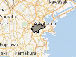
 Location of Minami in Kanagawa | |
 Minami | |
| Coordinates: 35°25′53″N 139°36′32″E | |
| Country | Japan |
| Region | Kantō |
| Prefecture | Kanagawa |
| City | Yokohama |
| Area | |
| • Total | 12.67 km2 (4.89 sq mi) |
| Population (February 2010) | |
| • Total | 197,019 |
| • Density | 15,500/km2 (40,000/sq mi) |
| Time zone | UTC+9 (Japan Standard Time) |
| - Flower | Sakura |
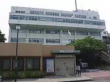
| Address | 3-48-1 Hananoki-chō, Minami-ku Yokohama-shi, Kanagawa-ken 232-0018 |
| Website | Minami Ward Office |
Geography
Minami Ward is located in eastern Kanagawa Prefecture, and south of the geographic center of the city of Yokohama. Large buildings and apartment complexes are built up along the area surrounding the highways and railways in the Ward; and all other parts of the Ward are residential areas. The Ōoka River is the major river in the Ward, and in spring many cherry blossoms come into full bloom on its banks. Gumyō-ji, located in the southern part of the ward, is the oldest Buddhist temple in Yokohama.
Surrounding municipalities
- Hodogaya Ward
- Nishi Ward
- Isogo Ward
- Naka Ward
- Totsuka Ward
- Konan Ward
History
Part of the domains of the Miura clan during and after the Kamakura period, the area of present-day Minami Ward was part of the tenryō territory in Musashi Province controlled directly by the Tokugawa shogunate, but administered through various hatamoto. During the Bakumatsu period, the area was the site of the 1863 Idogaya Incident in which anti-foreign rōnin assassinated a soldier of the French mission in Yokohama, precipitating a diplomatic incident.
After the Meiji Restoration, the area was transferred to the new Kuraki District of Kanagawa Prefecture, and divided into numerous villages. The area was absorbed into the growing city of Yokohama in four phases: 1895, 1901, 1905 and 1927. On October 1, 1927, what is now Minami Ward became part of Naka Ward within Yokohama. On December 1, 1943, Naka Ward was divided into present-day Naka Ward and Minami Ward. In a major administrative reorganization of October 1, 1969, Minami Ward was further divided into the present-day Minami Ward and Kōnan Ward.
Koganecho, an area known since World War II for black marketing and brothels, was located along the Ōoka River in the ward. In preparation for Yokohama's 2009 150th anniversary celebrations of opening up as a port, police chased away the prostitutes from the area starting in 2005. Since then, the area has undergone redevelopment.[1]
Economy
Minami Ward is largely a regional commercial center and bedroom community for central Yokohama and Tokyo due to its extensive commuter train infrastructure.
Transportation
Railroads
Highways
- Shuto Expressway Kanagawa No. 3
- Yokohama Yokosuka Road
- Route 16
Prefecture roads
- Kanagawa Prefecture Road 21
- Kanagawa Prefecture Road 218
Education
- Private schools
- Aoyama Gakuin Yokohama Eiwa High School (formerly Yokohama Eiwa Girls' School)
Local attractions
- Gumyōji temple
- Yokohama Municipal Children's Botanical Garden
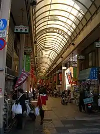
- Yokohama-Bashi Shopping district
in Maganechō(横浜橋商店街,真金町)
Noted people from Minami Ward
- Yuki Saito, actress
- Erika Umeda, singer
- Tadanobu Asano, singer
- Yuichi Nakamura, actor
- Akira Kamiya, voice actor
- Shunji Karube, Olympic runner
References
- Kato, Yuzo. Yokohama Past and Present. Yokohama City University (1990).
- Mitchell, Jon, "Koganecho transformed: from sleaze to teas", Japan Times, 24 March 2011, p. 10.
| Wikimedia Commons has media related to Minami-ku, Yokohama. |
External links
- Minami Ward Office
- City of Yokohama statistics
 Geographic data related to Minami-ku, Yokohama at OpenStreetMap
| Yokohama |
| |||
|---|---|---|---|---|
| Kawasaki |
| |||
| Sagamihara |
| |||
| Core city | ||||
| Special cities | ||||
| Cities | ||||
| Districts | ||||
| Authority control |
|---|