Minnesota State Highway 252
Minnesota State Highway 252 (MN 252) is a 4.353-mile-long (7.005 km) highway in Minnesota, which runs from its interchange with Interstate Highways 94 and 694 and US 52 in Brooklyn Center and continues north to its northern terminus at its interchange with State Highway 610 in Brooklyn Park. MN 252 generally follows not far from the west bank of the Mississippi River throughout its route.
| ||||
|---|---|---|---|---|
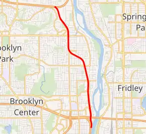
MN 252 highlighted in red | ||||
| Route information | ||||
| Defined by MS § 161.115(41) | ||||
| Maintained by MnDOT | ||||
| Length | 4.353 mi[1] (7.005 km) | |||
| Existed | 1977-78–present | |||
| Major junctions | ||||
| South end | ||||
| North end | ||||
| Location | ||||
| Counties | Hennepin | |||
| Highway system | ||||
| ||||

Route description
State Highway 252 serves as a north–south route in suburban Hennepin County between Brooklyn Center and Brooklyn Park. The route is heavily stoplighted and has a 55 MPH posted speed limit. Highway 252 is built as an expressway with access limited to signalized intersections and interchanges only.
Highway 252, together with State Highway 610, serve as a connection between the northern suburbs and Interstate 94/US Highway 52 towards downtown Minneapolis.
The route is built as a six-lane expressway from I-94 / I-694 / US 52 to 73rd Avenue North. The route is built as a four-lane expressway from 73rd Avenue North to its junction with Highway 610.
The 4.5 mile highway is one of the most traveled highways in the state that still has traffic signals; and for which interchanges are not immediately planned. Highway 252 near its junction with I-94 / I-694 / US 52 in Brooklyn Center, carries 70,000 vehicles a day as of 2006.
Legally, Highway 252 is defined as part of unmarked legislative route 110 in the Minnesota Statutes. Highway 252 is not marked with this legislative number along the actual highway.
History
Highway 252 was marked in the late 1970s.[2][3] Previously, this was the old routing of U.S. Highway 169 between downtown Minneapolis and the present day suburb of Champlin. Old U.S. 169 had followed Lyndale Avenue North out of downtown Minneapolis and proceeded northbound to a junction with old U.S. Highway 52 (now U.S. 169) in Champlin.
Highway 169 was rerouted west of that position in the late 1970s, and this route was then renumbered Highway 252. After intersecting State Highway 610 was built, and as part of the 1988 highway swap, the portion of 252 north of Highway 610 was turned back to Hennepin County maintenance and renumbered Hennepin County Road 12.[4]
Highway 252 was built to expressway standards in the mid 1980s.[4]
The intersection of Highway 252 and 85th Avenue North in Brooklyn Park is particularly dangerous for pedestrians to cross. In 1999, an 11-year-old girl, Kara Kavanaugh, was struck by a car and killed at the intersection, sparking renewed debate about building a pedestrian bridge in that location.[5] In 2004, a pedestrian bridge was finally built in this location, and dedicated to Kara Kavanaugh.[6]
Major intersections
The entire route is in Hennepin County.
| Location | mi[1] | km | Destinations | Notes | |
|---|---|---|---|---|---|
| Brooklyn Center | 0.000 | 0.000 | Southbound exit and northbound entrance | ||
| 0.083– 0.460 | 0.134– 0.740 | No access from northbound 252 to westbound 94/694 | |||
| 1.459– 1.478 | 2.348– 2.379 | 73rd Avenue North | Signalized at-grade intersection, border between Brooklyn Center and Brooklyn Park | ||
| Brooklyn Park | 3.233– 3.239 | 5.203– 5.213 | Signalized at-grade intersection | ||
| 3.795– 4.353 | 6.107– 7.005 | Interchange | |||
| 1.000 mi = 1.609 km; 1.000 km = 0.621 mi | |||||
References
- "Trunk Highway Log Point Listing - Construction District 5" (PDF). Minnesota Department of Transportation. August 20, 2010. Archived from the original (PDF) on June 27, 2011. Retrieved December 29, 2010.
- 1977-78 Official Highway Map of Minnesota (Map). Minnesota Department of Transportation. 1977. Metropolitan St. Paul-Minneapolis inset. § V23-W24. Retrieved December 29, 2010.
- 1979-1980 Official Transportation Map of Minnesota (Map). Minnesota Department of Transportation. 1979. Metropolitan St. Paul-Minneapolis inset. § V23-W24. Retrieved December 29, 2010.
- Riner, Steve. "Details of routes 219–287". The Unofficial Minnesota Highways Page. Self-published. Retrieved December 29, 2010.
- Rosengren, John (2006). "A Bridge Too Far". Archived from the original on May 7, 2005. Retrieved April 6, 2006.
- "Highway 252 bridge honored for design". Minnesota Sun Newspapers. 2005. Retrieved April 6, 2006.