Hennepin County, Minnesota
Hennepin County (/ˈhɛnəpɪn/ HEN-ə-pin) is a county in the U.S. state of Minnesota. As of the 2010 census the population was 1,152,425.[2] It is the most populous county in Minnesota and the 32nd-most populous county in the United States; more than one in five Minnesotans live in Hennepin County. Its county seat is Minneapolis,[3] the state's most populous city. The county is named in honor of the 17th-century explorer Father Louis Hennepin.[4] Hennepin County is included in the Minneapolis-St. Paul-Bloomington Metropolitan Statistical Area. The center of population of Minnesota is in Hennepin County, in the City of Minneapolis.
Hennepin County | |
|---|---|
| County of Hennepin | |
 The Hennepin County Government Center, located in the county seat of Minneapolis. Its stylized letter "H" shape serves as the logo for Hennepin County. | |
Logo | |
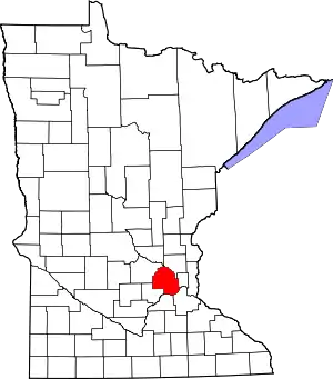 Location within the U.S. state of Minnesota | |
 Minnesota's location within the U.S. | |
| Coordinates: 44°58′33″N 93°16′00″W | |
| Country | |
| State | |
| Founded | March 6, 1852[1] |
| Named for | Louis Hennepin |
| Seat | Minneapolis |
| Largest city | Minneapolis |
| Area | |
| • Total | 607 sq mi (1,570 km2) |
| • Land | 554 sq mi (1,430 km2) |
| • Water | 53 sq mi (140 km2) 8.7%% |
| Population (2010) | |
| • Total | 1,152,425 |
| • Estimate (2019) | 1,278,869 |
| • Density | 2,082/sq mi (804/km2) |
| Time zone | UTC−6 (Central) |
| • Summer (DST) | UTC−5 (CDT) |
| Area code | 612, 763, 952 |
| Congressional districts | 3rd, 5th |
| Website | www |
History
Hennepin County was created in 1852 by the Minnesota Territorial Legislature. Father Louis Hennepin's name was chosen because he originally named St. Anthony Falls and recorded some of the earliest accounts of the area for the Western world. Hennepin County's early history is closely linked to the establishment of the cities of Minneapolis and St. Anthony.[5]
Geography
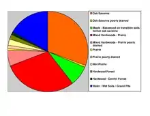
According to the U.S. Census Bureau, the county has a total area of 607 square miles (1,570 km2), of which 554 square miles (1,430 km2) is land and 53 square miles (140 km2) (8.7%) is water.[6] Hennepin is one of 17 Minnesota counties with more savanna soils than either prairie or forest soils, and is one of only two Minnesota counties with more than 75% of its area in savanna soils (the other is Wright County).
The highest waterfall on the Mississippi River, the Saint Anthony Falls (discovered by Louis Hennepin) is in Hennepin County next to downtown Minneapolis, but in the 19th century, the falls were converted to a series of dams. Barges and boats now pass through locks to move between the parts of the river above and below the dams.
Adjacent counties
- Anoka County (northeast)
- Ramsey County (east)
- Dakota County (southeast)
- Scott County (south)
- Carver County (southwest)
- Wright County (northwest)
- Sherburne County (north)
National protected areas
Demographics
| Historical population | |||
|---|---|---|---|
| Census | Pop. | %± | |
| 1860 | 12,849 | — | |
| 1870 | 31,566 | 145.7% | |
| 1880 | 67,013 | 112.3% | |
| 1890 | 185,294 | 176.5% | |
| 1900 | 228,340 | 23.2% | |
| 1910 | 333,480 | 46.0% | |
| 1920 | 415,419 | 24.6% | |
| 1930 | 517,785 | 24.6% | |
| 1940 | 568,899 | 9.9% | |
| 1950 | 676,579 | 18.9% | |
| 1960 | 842,854 | 24.6% | |
| 1970 | 960,080 | 13.9% | |
| 1980 | 941,411 | −1.9% | |
| 1990 | 1,032,431 | 9.7% | |
| 2000 | 1,116,200 | 8.1% | |
| 2010 | 1,152,425 | 3.2% | |
| 2019 (est.) | 1,278,869 | [8] | 11.0% |
| U.S. Decennial Census[9] 1790-1960[10] 1900-1990[11] 1990-2000[12] 2010-2019[2] | |||

2010
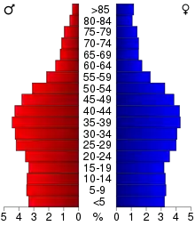
As of the 2010 Census, there were 1,152,425 people, 475,913 households, and 272,885 families living in the county. The racial makeup of the county was 74.4% White, 11.8% Black or African American, 0.9% Native American, 6.2% Asian, 3.4% from other races, and 3.2% from two or more races. 6.7% of the population were Hispanic or Latino of any race.
According to the 2010–2015 American Community Survey, the largest ancestry groups were German (26.3%), Norwegian (12.6%), Irish (10.8%), and Swedish (8.3%).[13]
2000
At the 2000 Census, there were 1,116,200 people, 456,129 households, and 267,291 families living in the county. The population density was 774/km2 (2,005/mi2). There were 468,824 housing units at an average density of 325/km2 (842/mi2). The racial makeup of the county was 80.53% White, 8.95% Black or African American, 1.00% Native American, 4.80% Asian, 0.05% Pacific Islander, 2.06% from other races, and 2.60% from two or more races. 4.07% of the population were Hispanic or Latino of any race.
There were 456,129 households, out of which 28.80% had children under the age of 18 living with them, 45.30% were married couples living together, 9.90% had a female householder with no husband present, and 41.40% were non-families. 31.80% of all households were made up of individuals, and 8.40% had someone living alone who was 65 years of age or older. The average household size was 2.39 and the average family size was 3.07.
In the county 24.00% of the population was under the age of 18, 9.70% was between 18 and 24, 33.70% from 25 to 44, 21.70% from 45 to 64, and 11.00% were 65 years of age or older. The median age was 35 years. For every 100 females there were 97.00 males. For every 100 females age 18 and over, there were 94.70 males.
The median income for a household in the county was $51,711, and the median income for a family was $65,985 (these figures had risen to $60,115 and $79,970 respectively as of a 2007 estimate). Accounting for inflation, these figures rise again to $76,202.87 for individuals, and $92,353.46 for households, adjusted for 2014 dollars.[14] Males had a median income of $42,466 versus $32,400 for females. The per capita income for the county was $28,789. About 5.00% of families and 8.30% of the population were below the poverty line, including 10.50% of those under age 18 and 5.90% of those age 65 or over.
Hennepin County is the wealthiest county in Minnesota and one of the 100 highest-income counties in the United States.
Besides English, languages with significant numbers of speakers in Hennepin County include Arabic, Hmong, Khmer, Lao, Russian, Somali, Spanish, and Vietnamese.[15]
Religious statistics
In 2010 statistics, the largest religious group in Hennepin County was the Archdiocese of Saint Paul and Minneapolis, with 215,205 Catholics worshipping at 73 parishes, followed by 124,732 ELCA Lutherans with 106 congregations, 59,811 non-denominational adherents with 103 congregations, 20,286 UMC Methodists with 42 congregations, 18,836 Missouri Synod Lutherans with 34 congregations, 16,941 PC-USA Presbyterians with 21 congregations, 16,230 Converge Baptists with 26 congregations, 16,128 AoG Pentecostals with 32 congregations, 12,307 UCC Christians with 20 congregations, and 8,608 Reform Jews with 3 congregations. Altogether, 54.3% of the population was claimed as members by religious congregations, although members of historically African-American denominations were underrepresented due to incomplete information.[16] In 2014, Hennepin County had 708 religious organizations, the 16th most out of all US counties.[17]
Law and government
Commissioners
Like all counties in Minnesota, Hennepin is governed by an elected and nonpartisan board of commissioners. In Minnesota, county commissions usually have five members, but Hennepin, Ramsey, Dakota, Anoka and St Louis counties have seven members. Each commissioner represents a district of approximately equal population. In Hennepin the county commission appoints the medical examiner, county auditor-treasurer and county recorder. The sheriff and county attorney are also elected on a nonpartisan ticket. The county government's headquarters are in downtown Minneapolis in the Hennepin County Government Center. The county oversees the Hennepin County Library system (which merged with the Minneapolis Public Library system in 2008), and Hennepin County Medical Center. The county commission also elects a chair who presides at meetings.
| District | Commissioner | In office since |
Current term expires in January |
|---|---|---|---|
| 1st | Mike Opat | 1993 | 2021 |
| 2nd | Irene Fernando | 2019 | 2023 |
| 3rd | Marion Greene (chair)[18] | 2014 | 2023 |
| 4th | Angela Conley | 2019 | 2023 |
| 5th | Debbie Goettel | 2017 | 2021 |
| 6th | Jan Callison | 2009 | 2021 |
| 7th | Jeff Johnson | 2009 | 2021 |
Key staff
Hennepin County's normal operations are coordinated by the County Administrator David Hough, Deputy County Administrator for Health and Human Services Jennifer DeCubellis, Assistant County Administrator for Operations Chester Cooper, Acting Assistant County Administrator for Public Works Chris Sagsveen, and Assistant County Administrator for Public Safety Mark Thompson. Under Administrator Hough's leadership, the number senior management positions in the county has grown by 40%.
Politics
Like most urban counties nationwide, Hennepin County is a Democratic stronghold. It has voted Democratic in every election since 1964, except for 1972 when Richard Nixon won the county as part of a national landslide. In 2020, Donald Trump's performance was the worst for any Republican in the county's history.
| Year | Republican | Democratic | Third parties |
|---|---|---|---|
| 2020 | 27.2% 205,973 | 70.4% 532,623 | 2.3% 17,373 |
| 2016 | 28.2% 191,770 | 63.1% 429,288 | 8.7% 58,919 |
| 2012 | 35.3% 240,073 | 62.3% 423,982 | 2.4% 16,010 |
| 2008 | 34.8% 231,054 | 63.4% 420,958 | 1.8% 11,768 |
| 2004 | 39.4% 255,133 | 59.3% 383,841 | 1.2% 8,007 |
| 2000 | 39.3% 225,657 | 53.6% 307,599 | 7.1% 40,590 |
| 1996 | 33.2% 173,887 | 54.4% 285,126 | 12.5% 65,293 |
| 1992 | 30.6% 179,581 | 47.5% 278,648 | 21.9% 128,390 |
| 1988 | 44.6% 240,209 | 54.4% 292,909 | 1.0% 5,444 |
| 1984 | 48.0% 253,921 | 51.5% 272,401 | 0.6% 2,912 |
| 1980 | 38.6% 194,898 | 47.4% 239,592 | 14.0% 70,882 |
| 1976 | 43.8% 211,892 | 53.3% 257,380 | 2.9% 14,106 |
| 1972 | 51.6% 228,951 | 46.5% 205,943 | 1.9% 8,464 |
| 1968 | 41.8% 170,002 | 54.1% 220,078 | 4.2% 16,944 |
| 1964 | 39.0% 154,736 | 60.8% 241,020 | 0.2% 971 |
| 1960 | 51.3% 198,992 | 48.5% 188,250 | 0.2% 939 |
| 1956 | 55.0% 183,248 | 44.8% 149,341 | 0.2% 523 |
| 1952 | 53.5% 180,338 | 46.1% 155,388 | 0.4% 1,415 |
| 1948 | 42.9% 121,169 | 53.8% 151,920 | 3.2% 9,145 |
| 1944 | 43.7% 116,781 | 55.7% 148,792 | 0.7% 1,747 |
| 1940 | 45.5% 122,960 | 53.7% 145,168 | 0.8% 2,230 |
| 1936 | 33.1% 81,206 | 58.8% 144,289 | 8.1% 19,985 |
| 1932 | 41.9% 91,087 | 54.8% 119,234 | 3.3% 7,245 |
| 1928 | 60.2% 125,472 | 38.8% 80,851 | 1.0% 2,124 |
| 1924 | 59.0% 101,120 | 6.3% 10,806 | 34.7% 59,401 |
| 1920 | 64.6% 90,517 | 20.6% 28,911 | 14.8% 20,741 |
| 1916 | 40.8% 27,957 | 53.1% 36,395 | 6.1% 4,204 |
| 1912 | 29.6% 14,379 | 32.0% 15,530 | 38.3% 18,596[20] |
| 1908 | 58.7% 27,787 | 34.2% 16,169 | 7.1% 3,357 |
| 1904 | 73.7% 31,437 | 13.4% 5,708 | 12.9% 5,503 |
| 1900 | 62.4% 26,902 | 33.6% 14,498 | 3.9% 1,695 |
| 1896 | 55.5% 26,786 | 42.5% 20,515 | 2.0% 987 |
| 1892 | 49.9% 20,603 | 39.9% 16,448 | 10.2% 4,209 |
Transportation
Major highways
 Interstate 35W
 Interstate 94
 Interstate 394
 Interstate 494
 Interstate 694
 US Highway 12
 US Highway 52
.svg.png.webp) US Highway 169
US Highway 169.svg.png.webp) US Highway 212
US Highway 212 Minnesota State Highway 5
 Minnesota State Highway 7
 Minnesota State Highway 47
 Minnesota State Highway 55
 Minnesota State Highway 62
 Minnesota State Highway 65
 Minnesota State Highway 77
 Minnesota State Highway 100
 Minnesota State Highway 101
 Minnesota State Highway 121
 Minnesota State Highway 252
 Minnesota State Highway 610
 Hennepin County Road 17 (France Avenue)
 Hennepin County Road 61
 Hennepin County Road 81
 Hennepin County Road 122
- Other county roads
Airports
- Minneapolis–Saint Paul International Airport (MSP) serves the Twin Cities area. It is the 17th-busiest airport in the United States by passenger traffic and serves as a hub for Delta Air Lines.
- Crystal Airport (MIC) is a public airport in Crystal.
- Flying Cloud Airport (FCM) is a public airport in Eden Prairie.
Economy
Major companies and employers
As the economic center of Minnesota and the Upper Midwest, Hennepin County is home to many major companies in a diverse section of industries. As of the 2018 estimate, there are twelve Fortune 500 companies headquartered in Hennepin County, five of which are located in Minneapolis.
| Company Name | National Rank | Revenue ($millions),
2018 Estimate |
Headquarters City | Industry |
|---|---|---|---|---|
| UnitedHealth Group | 5 | 201,159 | Minnetonka | Managed Healthcare |
| Target | 39 | 71,879 | Minneapolis | General Retailing |
| Best Buy | 72 | 42,151 | Richfield | Electronics Retailing |
| U.S. Bancorp | 122 | 23,996 | Minneapolis | Banking and Finance |
| SuperValu | 180 | 16,009 | Eden Prairie | Food Distribution and Retailing |
| General Mills | 182 | 15,619.8 | Golden Valley | Food Processing |
| C.H. Robinson | 193 | 14,869.4 | Eden Prairie | Transportation |
| Ameriprise Financial | 252 | 12,075 | Minneapolis | Financial Services |
| Xcel Energy | 266 | 11,404 | Minneapolis | Electricity and Natural Gas Utility |
| Thrivent Financial | 343 | 8,527.9 | Minneapolis | Financial Services |
| Mosaic | 382 | 7,409.4 | Plymouth | Fertilizer Manufacturing |
| Polaris | 496 | 5,504.8 | Medina | Snowmobile Manufacturing |
.svg.png.webp)
Hennepin County is also home to several major private companies such as Carlson and Cargill, both located in Minnetonka, the latter of which is the largest privately owned company in the United States.[22]
Along with these major companies, Hennepin County also contains several large employers, as listed below. According to the 2016 American Community Survey, the largest overall industries in Hennepin County are healthcare and social assistance (96,511 workers), manufacturing (80,324), and retail trade (75,861).[23]
| Employer | Number of Employees | Industry |
|---|---|---|
| University of Minnesota | 18000 | Education |
| Target Stores Inc | 10000 | Retail |
| Pharmacy at Park Nicollet | 9000 | Healthcare |
| Park Nicollet Methodist Hospital | 8200 | Healthcare |
| Park Nicollet Clinic | 8000 | Healthcare |
| M Health Fairview University of Minnesota Medical Center | 8000 | Healthcare |
| M Health Fairview University of Minnesota Masonic Children's Hospital | 7658 | Healthcare |
| Ameriprise Financial Inc | 7000 | Financial Services |
| Park Nicollet Urgent Care | 7000 | Healthcare |
| Best Buy Inc | 6000 | Electronics Retail |
Economic indicators
According to the 2016 American Community Survey, the average household income in Hennepin County is $71,200. The GINI Index for 2016 was 0.461, lower than the national average of 0.485.[23] As of 2016, nearly 132,000 residents of Hennepin County were living under the poverty line, a full 10.9% of the county.[23] This figure is lower than the national average of 14%.
Education
Colleges and universities in the county include:
- Augsburg University in Minneapolis
- Dunwoody College of Technology in downtown Minneapolis
- Hamline University - Minneapolis campus in St. Louis Park
- Hennepin Technical College in Brooklyn Park and Eden Prairie
- Metropolitan State University in downtown Minneapolis and Brooklyn Park
- Minneapolis College of Art and Design in Minneapolis
- Minneapolis Community and Technical College in downtown Minneapolis
- Minnesota State University, Mankato - Twin Cities campus in Edina
- Normandale Community College in Bloomington
- North Central University in downtown Minneapolis
- North Hennepin Community College in Brooklyn Park
- Northwestern Health Sciences University in Bloomington
- St. Cloud State University - Twin Cities campus in Plymouth
- Saint Mary's University of Minnesota - Twin Cities campus in Minneapolis
- University of Minnesota - Twin Cities campus in Minneapolis
- University of St. Thomas - Minneapolis campus in downtown Minneapolis
Recreation

Parks
Hennepin County, and in particular the city of Minneapolis, is renowned for its expansive and high-quality park system. The Minneapolis park system has been called[25] the best-designed, best-financed, and best-maintained in America.[26] The Minneapolis park system has been named the top park system in the country by the Trust for Public Land for five consecutive years as of 2017.[27] Many of the Minneapolis' numerous parks are linked by the Grand Rounds National Scenic Byway, a series of interconnected parks and paths in the city that extends for 51 miles. The byway is divided into seven districts: Downtown Riverfront, Mississippi River, Minnehaha, Chain of Lakes, Theodore Wirth, Victory Memorial, and Northeast.[28] The byway includes many major destinations in Minneapolis, including Nicollet Island, St. Anthony Falls, Stone Arch Bridge, Mill Ruins Park, Mississippi National River and Recreation Area, Minnehaha Creek, Minnehaha Park, Lake Hiawatha, Lake Nokomis, Lake Harriet, Bde Maka Ska, Lake of the Isles, Cedar Lake, and Theodore Wirth Park.
Outside of Minneapolis, Hennepin County is part of the Three Rivers Park District, a park system containing 20 parks and 10 trails spanning the Twin Cities metro area.
Culture
Numerous art institutions in Minneapolis make Hennepin County a national center for the arts. It contains some of the largest and most well-known centers for art in the country, including the Minneapolis Institute of Art, Walker Art Center, Weisman Art Museum, and the Minneapolis Sculpture Garden. Major art centers include Northeast Minneapolis and the Minneapolis neighborhood of North Loop. Minneapolis is home to many important artist organizations such as the Traffic Zone Center for Visual Art, the Handicraft Guild, and the Northeast Minneapolis Arts Association.
Hennepin County is also home to a thriving theater scene, highlighted by the Guthrie Theater, located in downtown Minneapolis. It is home to many theater companies such as Mixed Blood, Skewed Visions, Brave New Workshop, and Children's Theatre Company. Other notable theaters include the Orpheum Theatre, the State Theatre, and the Pantages Theatre. Additionally, many other cities in Hennepin County are home to local community theaters, such as Eden Prairie, Minnetonka, Orono, Osseo, and Plymouth.

Sports
Of the "Big Four" sports leagues in the US, three are located in Minneapolis: the Minnesota Twins play in Target Field, the Minnesota Timberwolves play in Target Center, and the Minnesota Vikings play in U.S. Bank Stadium. Additionally, among major sports leagues, the Minnesota Lynx also play in Target Center.[29]
Cities
- Bloomington
- Brooklyn Center
- Brooklyn Park
- Champlin
- Corcoran
- Crystal
- Dayton (partial)
- Deephaven
- Eden Prairie
- Edina
- Excelsior
- Golden Valley
- Greenfield
- Greenwood
- Hanover (partial)
- Hopkins
- Independence
- Long Lake
- Loretto
- Maple Grove
- Maple Plain
- Medicine Lake
- Medina
- Minneapolis (county seat and largest municipality)
- Minnetonka
- Minnetonka Beach
- Minnetrista
- Mound
- New Hope
- Orono
- Osseo
- Plymouth
- Richfield
- Robbinsdale
- Rockford (partial)
- Rogers
- Shorewood
- Spring Park
- St. Anthony (partial)
- St. Bonifacius
- St. Louis Park
- Tonka Bay
- Wayzata
- Woodland
Unorganized territory
References
- "Minnesota Place Names". Minnesota Historical Society. Archived from the original on June 20, 2012. Retrieved March 18, 2014.
- "State & County QuickFacts". United States Census Bureau. Archived from the original on June 7, 2011. Retrieved September 1, 2013.
- "Find a County". National Association of Counties. Archived from the original on May 31, 2011. Retrieved June 7, 2011.
- Gannett, Henry (1905). The Origin of Certain Place Names in the United States. Govt. Print. Off. p. 155.
- JoEllen Haugo and Mary Jo Laakso (2001). "History of Minneapolis". Minneapolis Public Library. Archived from the original on August 15, 2007. Retrieved September 7, 2007.
- "2010 Census Gazetteer Files". United States Census Bureau. August 22, 2012. Archived from the original on October 6, 2014. Retrieved October 15, 2014.
- Nelson, Steven (2011). Savanna Soils of Minnesota. Minnesota: Self. pp. 49-52. ISBN 978-0-615-50320-2.
- "Population and Housing Unit Estimates". Retrieved March 26, 2020.
- "U.S. Decennial Census". United States Census Bureau. Retrieved October 15, 2014.
- "Historical Census Browser". University of Virginia Library. Retrieved October 15, 2014.
- "Population of Counties by Decennial Census: 1900 to 1990". United States Census Bureau. Retrieved October 15, 2014.
- "Census 2000 PHC-T-4. Ranking Tables for Counties: 1990 and 2000" (PDF). United States Census Bureau. Retrieved October 15, 2014.
- "2015 American Community Survey". Archived from the original on February 13, 2020. Retrieved August 22, 2017.
- "Inflation Calculator". www.dollartimes.com.
- "Welcome Languages Archived July 8, 2010, at the Wayback Machine." Hennepin County Public Library. Retrieved on July 8, 2010.
- "County Membership Report Hennepin County (Minnesota)". The Association of Religion Data Archives. 2010. Retrieved January 2, 2020.
- "Social Capital Variables Spreadsheet for 2014". PennState College of Agricultural Sciences, Northeast Regional Center for Rural Development. December 8, 2017. Retrieved December 30, 2019.
- "Marion Greene, District 3". Hennepin.us. Retrieved March 7, 2019.
- Leip, David. "Dave Leip's Atlas of U.S. Presidential Elections". uselectionatlas.org.
- The leading "other" candidate, Progressive Theodore Roosevelt, received 11,489 votes, while Socialist candidate Eugene Debs received 5,820 votes, Prohibition candidate Eugene Chafin received 668 votes, and Socialist Labor candidate Arthur Reimer received 619 votes.
- "Fortune 500 Companies 2018: Who Made the List". Fortune. Retrieved November 15, 2018.
- "America's Largest Private Companies". Forbes. Retrieved November 15, 2018.
- "Hennepin County, MN". Data USA. Retrieved November 26, 2018.
- Team, XPAND Corporation: America's Career InfoNet Development. "America's Career InfoNet: Largest Employers". www.careerinfonet.org. Retrieved November 26, 2018.
- “Great City Parks.” Great City Parks, by Alan Tate, Spon Press, 2004, pp. 187–192.
- Cameron, Mark (December 1996). "Reviews : The American City: What Works, What Doesn't Alexander Garvin McGraw-Hill. New York, New York 1995. 475 pages. $59.95". Journal of Planning Education and Research. 16 (2): 148–149. doi:10.1177/0739456x9601600210. ISSN 0739-456X. S2CID 144995220.
- "Minneapolis parks garner top honor five years running". Southwest Journal. May 26, 2017. Retrieved December 10, 2018.
- "Grand Rounds Scenic Byway System". www.minneapolisparks.org. Retrieved December 10, 2018.
- "Sports Teams : Explore Minnesota". www.exploreminnesota.com. Retrieved December 10, 2018.
External links
- Hennepin County Government website
- Hennepin County Library website
- Bloomington Convention & Visitors Bureau
- Minneapolis Northwest Convention & Visitors Bureau
Places adjacent to Hennepin County, Minnesota | ||||||||||
|---|---|---|---|---|---|---|---|---|---|---|
| ||||||||||
Municipalities and communities of Hennepin County, Minnesota, United States | ||
|---|---|---|
| Cities |
| Map of Minnesota highlighting Hennepin County |
| Unincorporated areas | ||
| Footnotes | ‡This populated place also has portions in an adjacent county or counties | |
| ||

| Authority control |
|---|