Brooklyn Park, Minnesota
Brooklyn Park is the sixth largest city in the U.S. state of Minnesota. The city is on the west bank of the Mississippi River, upstream from (north of) downtown Minneapolis in northern Hennepin County. Brooklyn Park is a northwest suburb of the Twin Cities metropolitan area.
Brooklyn Park | |
|---|---|
 Brooklyn Park City Hall in November 2006 | |
 Seal | |
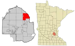 Location of the city of Brooklyn Park within Hennepin County, Minnesota | |
| Coordinates: 45°5′39″N 93°21′22″W | |
| Country | United States |
| State | Minnesota |
| County | Hennepin |
| Founded | 1850s |
| Incorporated | 1954 |
| Government | |
| • Mayor | Jeffrey Lunde (R)[1] |
| Area | |
| • City | 26.55 sq mi (68.76 km2) |
| • Land | 26.08 sq mi (67.54 km2) |
| • Water | 0.47 sq mi (1.22 km2) 1.88% |
| Elevation | 869 ft (265 m) |
| Population | |
| • City | 75,781 |
| • Estimate (2019)[4] | 80,389 |
| • Rank | US: 432th MN: 6th |
| • Density | 3,082.87/sq mi (1,190.32/km2) |
| • Metro | 3,629,190 (US: 16th) |
| Time zone | UTC−6 (Central) |
| • Summer (DST) | UTC−5 (Central) |
| ZIP codes | 55428, 55429, 55443, 55444, 55445 |
| Area code | 763 |
| FIPS code | 27-07966 |
| GNIS feature ID | 0640511[5] |
| Website | brooklynpark.org |
The population of Brooklyn Park was 75,781 at the 2010 census[6] and estimated in 2019 to be 80,389.[7]
Brooklyn Park is listed as a "Tree City USA" and is home to 47 miles (76 km) of trails and 67 parks, including the Rush Creek Regional Trail and the northern section of Palmer Lake Park. The city is also known for the West Coon Rapids Dam, on the west side of the Mississippi River. North Hennepin Community College and a campus of Hennepin Technical College are in the city.
Brooklyn Park is a "bedroom community" of Minneapolis and Saint Paul and is considered both a second- and third-tier suburb, because much of the land north of 85th Avenue was developed after 2000. The city still has undeveloped land and farms, including the historic Eidem Homestead, a 1900s working farm that is a popular tourist attraction for families and school field trips.
History
Formerly Brooklyn Township, the township split in 1860, with the southeast village later incorporating into Brooklyn Center and Crystal. Settlers from Michigan formally established the township and named it after their hometown of Brooklyn, Michigan.[8] Brooklyn Park incorporated as a village in 1954, and incorporated as a city in 1969.
Geography
According to the United States Census Bureau, the city has a total area of 26.57 square miles (68.82 km2), of which 26.07 square miles (67.52 km2) are land and 0.50 square miles (1.29 km2), or 1.87%, are water.[9] The Mississippi River forms the eastern boundary of the city, separating it from Coon Rapids and Fridley in Anoka County.
Interstates 94 and 694 are located in the far southern portion of Brooklyn Park. U.S. Highway 169 is located near the western part of the city. State Highway 252, a 4.5-mile (7.2 km) north–south highway, is located near the eastern portion of the city. State Highway 610 runs east–west through the northern portion of Brooklyn Park. County Road 81 also serves as one of the main routes.
Demographics
| Historical population | |||
|---|---|---|---|
| Census | Pop. | %± | |
| 1860 | 608 | — | |
| 1870 | 1,024 | 68.4% | |
| 1880 | 1,060 | 3.5% | |
| 1890 | 1,254 | 18.3% | |
| 1900 | 1,232 | −1.8% | |
| 1910 | 1,268 | 2.9% | |
| 1920 | 948 | −25.2% | |
| 1930 | 1,107 | 16.8% | |
| 1940 | 1,334 | 20.5% | |
| 1950 | 3,065 | 129.8% | |
| 1960 | 10,197 | 232.7% | |
| 1970 | 26,230 | 157.2% | |
| 1980 | 43,332 | 65.2% | |
| 1990 | 56,381 | 30.1% | |
| 2000 | 67,388 | 19.5% | |
| 2010 | 75,781 | 12.5% | |
| 2019 (est.) | 80,389 | [4] | 6.1% |
| U.S. Decennial Census[10] 2018 Estimate[11] | |||
2010 census
As of the census[3] of 2010, there were 75,781 people, 26,229 households, and 18,763 families living in the city. The population density was 2,906.8 inhabitants per square mile (1,122.3/km2). There were 27,841 housing units at an average density of 1,067.9 per square mile (412.3/km2). The racial makeup of the city was 52.2% White, 24.4% African American, 0.5% Native American, 15.4% Asian, 0.1% Pacific Islander, 3.6% from other races, and 3.7% from two or more races. Hispanic or Latino of any race were 6.4% of the population.
There were 26,229 households, of which 41.0% had children under the age of 18 living with them, 50.7% were married couples living together, 15.0% had a female householder with no husband present, 5.8% had a male householder with no wife present, and 28.5% were non-families. 22.3% of all households were made up of individuals, and 5.7% had someone living alone who was 65 years of age or older. The average household size was 2.88 and the average family size was 3.40.
The median age in the city was 32.5 years. 29% of residents were under the age of 18; 9.6% were between the ages of 18 and 24; 29.1% were from 25 to 44; 24.7% were from 45 to 64; and 7.8% were 65 years of age or older. The gender makeup of the city was 48.9% male and 51.1% female.
2000 census
According to the 2000 census, there were 67,388 people, 24,432 households, and 17,346 families living in the city. The population density was 2,586.1 people per square mile (998.4 per km2). There were 24,846 housing units at an average density of 953.5 per square mile (368.1 per km2). The racial makeup of the city was 71.44% White, 14.33% African American, 0.57% Native American, 9.22% Asian, 0.07% Pacific Islander, 1.49% from other races, and 2.88% from two or more races. Hispanic or Latino of any race totaled 4,481 residents in the city. Hispanic or Latino of any race were 2.88% of the population.
There were 24,432 households, out of which 39.2% had children under the age of 18 living with them, 54.6% were married couples living together, 12.1% had a female householder with no husband present, and 29.0% were non-families. 22.0% of all households were made up of individuals, and 3.7% had someone living alone who was 65 years of age or older. The average household size was 2.75 and the average family size was 3.26.
In the city, the age distribution of the population showed 28.8% under the age of 18, 9.7% from 18 to 24, 34.9% from 25 to 44, 20.9% from 45 to 64, and 5.6% who were 65 years of age or older. The median age was 32 years. For every 100 females, there were 98.7 males. For every 100 females age 18 and over, there were 95.8 males.
The median household income/owner occupied was $88,972. The median household income/renter occupied was $42,541. The combined median income for a household in the city was $64,297. The per capita income for the city was $23,199. About 3.8% of families and 5.1% of the population were below the poverty line, including 6.3% of those under age 18 and 4.7% of those age 65 or over.
Parks and recreation
The Three Rivers Figure Skating Club operates out of the Brooklyn Park Community Activity Center.[12][13]
Government
Brooklyn Park is served by a six-member city council, two members for each voting district within the city. The three districts are West, East, and Central. The mayor is Jeffrey Lunde, who won a 12-way special election in April 2011 with 31% of the vote. [14]
Education
Brooklyn Park is served by three school districts: Osseo Area School District 279, Anoka-Hennepin School District 11, and Robbinsdale School District 281.
High schools serving Brooklyn Park:
- Champlin Park High School (Anoka-Hennepin District)
- Cooper Senior High School (Robbinsdale District)
- Osseo Senior High School (Osseo District)
- Park Center Senior High School (Osseo District)
Some students attend public schools in other school districts chosen by their families under Minnesota's open enrollment statute.[15]
Maranatha Christian Academy, a private high school, and St. Vincent de Paul Parish School, a Catholic school, are also in Brooklyn Park.
Colleges include North Hennepin Community College, Hennepin Technical College and Rasmussen College.
Notable people
- Casey Borer, ice hockey player for the Eisbären Berlin of the Deutsche Eishockey Liga (DEL)
- Dave Brat, former congressman from Virginia's 7th congressional district
- Ramon Humber, linebacker for the New Orleans Saints of the National Football League; alumnus of Champlin Park High School
- Tim Jackman, professional ice hockey player for the Anaheim Ducks of the National Hockey League; Park Center High School alumnus
- Tim Laudner, former Major League Baseball catcher for the Minnesota Twins; Park Center High School alumnus
- Dave Lindstrom, catcher Detroit Tigers Minors / Texas Tech University; Park Center High School alumnus
- Pat Neshek, relief pitcher Houston Astros; Park Center High School alumnus
- Dean Nyquist, attorney and member of the Minnesota Senate
- Kirby Puckett (1960–2006), Major League Baseball center fielder who spent his entire 12-year career playing for the Minnesota Twins; early in his career, Puckett lived in Brooklyn Park, with his wife, Tonya, who is from Brooklyn Park
- Jesse Ventura, politician, actor, author, veteran, and former professional wrestler, who served as the 38th governor of Minnesota from 1999 to 2003; served as mayor of Brooklyn Park from 1991 to 1995
- Krissy Wendell, ice hockey player, former player for the United States women's national ice hockey team, also standout softball/baseball player who played in Little League World Series; Park Center High School alumna
References
- Adams, Jim (June 10, 2014). "Two Brooklyns have 7 vying to be mayor". Star Tribune. Retrieved October 3, 2015.
Lunde, 46, a Republican
- "2019 U.S. Gazetteer Files". United States Census Bureau. Retrieved July 26, 2020.
- "U.S. Census website". United States Census Bureau. Retrieved November 13, 2012.
- "Population and Housing Unit Estimates". United States Census Bureau. May 24, 2020. Retrieved May 27, 2020.
- "US Board on Geographic Names". United States Geological Survey. October 25, 2007. Retrieved January 31, 2008.
- "Geographic Identifiers: 2010 Census Summary File 1 (G001): Brooklyn Park city, Minnesota". American Factfinder. U.S. Census Bureau. Archived from the original on February 13, 2020. Retrieved August 14, 2017.
- "Population and Housing Unit Estimates". Retrieved May 21, 2020.
- "Brooklyn Park History". City of Brooklyn Park. 2008. Archived from the original on February 10, 2012. Retrieved November 6, 2008.
- "US Gazetteer files 2010". United States Census Bureau. Archived from the original on July 2, 2012. Retrieved November 13, 2012.
- United States Census Bureau. "Census of Population and Housing". Retrieved August 14, 2013.
- "Population Estimates". United States Census Bureau. Retrieved July 14, 2019.
- "Three Rivers Figure Skating Club". Top Local Places. Retrieved October 27, 2015.
- "Ice Arenas – Recreation and Parks | Brooklyn Park". www.brooklynpark.org. Retrieved October 23, 2015.
- City of Brooklyn Park (2011), Special Election Results, archived from the original on May 3, 2011, retrieved April 30, 2011
- "Open Enrollment". Minnesota Department of Education. Archived from the original on August 26, 2010. Retrieved November 19, 2010.
External links
Municipalities and communities of Hennepin County, Minnesota, United States | ||
|---|---|---|
| Cities |
| 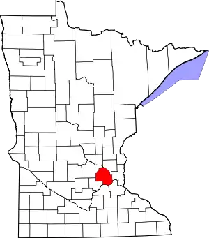 Map of Minnesota highlighting Hennepin County |
| Unincorporated areas | ||
| Footnotes | ‡This populated place also has portions in an adjacent county or counties | |
| ||

| Authority control |
|---|