Brooklyn Center, Minnesota
Brooklyn Center is a city in Hennepin County, Minnesota, United States. The city is on the west bank of the Mississippi River on the northwest border of Minneapolis. The population was 30,104 at the 2010 census.
Brooklyn Center | |
|---|---|
 Seal | |
| Motto(s): At The Center | |
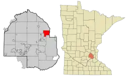 Location of the city of Brooklyn Center within Hennepin County, Minnesota | |
| Coordinates: 45°4′9″N 93°18′50″W | |
| Country | United States |
| State | Minnesota |
| County | Hennepin |
| Settled | 1852 |
| Incorporated (village) | 1911 |
| Incorporated (city) | 1966 |
| Government | |
| • Type | Council / Manager |
| • Mayor | Mike Elliott [1] |
| • City Manager | Curt Boganey |
| Area | |
| • City | 8.38 sq mi (21.71 km2) |
| • Land | 8.00 sq mi (20.73 km2) |
| • Water | 0.38 sq mi (0.98 km2) |
| Elevation | 853 ft (260 m) |
| Population | |
| • City | 30,104 |
| • Estimate (2019)[4] | 30,690 |
| • Density | 3,834.81/sq mi (1,480.56/km2) |
| • Metro | 3,629,190 |
| Time zone | UTC-6 (Central (CST)) |
| • Summer (DST) | UTC-5 (CDT) |
| Zip Code | 55429, 55430 |
| Area code(s) | 763 |
| FIPS code | 27-07948 |
| GNIS feature ID | 0640508[5] |
| Website | ci.brooklyn-center.mn.us |
Brooklyn Center is one of the original inner-ring suburbs of Minneapolis–Saint Paul, the sixteenth largest metropolitan area in the United States, with approximately 3.63 million residents.
Formed as the center of local trade in the former Brooklyn Township since 1873, the rural area farmed market gardening for the nearby growing population of Minneapolis. The village of Brooklyn Center incorporated in 1911, splitting from Brooklyn Township, to avoid annexation from the expanding city of Minneapolis. It incorporated as a city in 1966. The city became a bedroom community and industrial job center following postwar growth. It was the site of the regional mall Brookdale Center. The headquarters of Caribou Coffee moved into the city in 2004.[6]
Geography
According to the United States Census Bureau, the city has a total area of 8.34 square miles (21.60 km2), of which 7.96 square miles (20.62 km2) is land and 0.38 square miles (0.98 km2) is water.[7]
Interstates 94 and 694 and Minnesota State Highways 100 and 252 are four of the main routes in Brooklyn Center.
History
Known as the center of local trade in the former Brooklyn Township since 1873, the rural area farmed market gardening for the nearby growing population of Minneapolis. With fears the downtown city would continue annexation, the village of Brooklyn Center was established in 1911.[8] The city of Brooklyn Center was incorporated in 1966. The city contains the site of the historic Earle Brown farm, home to Earle Brown, founder of the Minnesota State Patrol and first Sheriff of Hennepin County. The farm has been refurbished and now contains a bed and breakfast, event center, and office spaces.
Education
Globe University/Minnesota School of Business, a private career college, offers master's, bachelor's and associate degree programs in business, information technology, health sciences and legal sciences at its Brooklyn Center campus.
Economy
When the Minnesota Educational Computing Consortium, also known as MECC, existed, its headquarters were in Brooklyn Center.[9][10]
Brooklyn Center is home to regional favorite Surly Brewing Company.
Minnesota Martial Arts Academy, now known simply as the Academy, an MMA training center, is in Brooklyn Center. It has trained such notable fighters as Sean Sherk and Brock Lesnar.
Brooklyn Center is home to the FBI's new Minneapolis field office, which began construction in August 2010.[11]
Top employers
According to Brooklyn Center's 2011 Comprehensive Annual Financial Report,[12] the top employers in the city are:
| # | Employer | # of Employees |
|---|---|---|
| 1 | Medtronic | 1,100 |
| 2 | Brooklyn Center Schools #286 | 385 |
| 3 | Caribou Coffee | 250 |
| 4 | Osseo Area School District 279 | 185 |
| 5 | City of Brooklyn Center | 160 |
| 6 | TCF | 150 |
| 7 | Target | 146 |
| 8 | TCR | 145 |
| 9 | Cub Foods | 130 |
| 10 | Walmart | 129 |
Demographics
| Historical population | |||
|---|---|---|---|
| Census | Pop. | %± | |
| 1920 | 788 | — | |
| 1930 | 1,344 | 70.6% | |
| 1940 | 1,870 | 39.1% | |
| 1950 | 4,284 | 129.1% | |
| 1960 | 24,356 | 468.5% | |
| 1970 | 35,173 | 44.4% | |
| 1980 | 31,230 | −11.2% | |
| 1990 | 28,887 | −7.5% | |
| 2000 | 29,172 | 1.0% | |
| 2010 | 30,104 | 3.2% | |
| 2019 (est.) | 30,690 | [4] | 1.9% |
| U.S. Decennial Census[13] 2018 Estimate[14] | |||
2010 census
As of the census[3] of 2010, 30,104 people, 10,756 households, and 7,010 families resided in the city. The population density was 3,781.9 inhabitants per square mile (1,460.2/km2). There were 11,640 housing units at an average density of 1,462.3 per square mile (564.6/km2). The racial makeup of the city was 49.1% White, 25.9% African American, 0.8% Native American, 14.3% Asian, 0.1% Pacific Islander, 5.4% from other races, and 4.4% from two or more races. Hispanic or Latino of any race were 9.6% of the population.
There were 10,756 households, of which 36.0% had children under the age of 18 living with them, 40.4% were married couples living together, 18.1% had a female householder with no husband present, 6.6% had a male householder with no wife present, and 34.8% were non-families. 27.7% of all households were made up of individuals, and 10.7% had someone living alone who was 65 years of age or older. The average household size was 2.78 and the average family size was 3.43.
The city's median age was 32.6 years. 27.6% of residents were under the age of 18; 10.1% were between the ages of 18 and 24; 28.1% were from 25 to 44; 22.1% were from 45 to 64; and 12.2% were 65 years of age or older. The gender makeup was 48.7% male and 51.3% female.
2000 census
As of the census of 2000, 29,172 people, 11,430 households, and 7,383 families resided in the city. The population density was 3,672.0 people per square mile (1,418.6/km2). There were 11,598 housing units at an average density of 1,459.9 per square mile (564.0/km2). The city's racial makeup was 71.39% White, 14.09% African American, 0.87% Native American, 8.79% Asian, 0.01% Pacific Islander, 1.49% from other races, and 3.36% from two or more races. Hispanic or Latino of any race were 2.82% of the population.
There were 11,430 households, out of which 29.7% had children under the age of 18 living with them, 46.3% were married couples living together, 13.4% had a female householder with no husband present, and 35.4% were non-families. 28.2% of all households were made up of individuals, and 11.0% had someone living alone who was 65 years of age or older. The average household size was 2.52 and the average family size was 3.11.
In the city, the population was spread out, with 25.1% under the age of 18, 9.6% from 18 to 24, 30.1% from 25 to 44, 19.8% from 45 to 64, and 15.4% who were 65 years of age or older. The median age was 35 years. For every 100 females, there were 94.9 males. For every 100 females age 18 and over, there were 91.8 males.
The city's median household income was $44,570, and the median family income was $52,006. Males had a median income of $36,031 versus $27,755 for females. The city's per capita income was $19,695. About 4.7% of families and 7.4% of the population were below the poverty line, including 10.7% of those under age 18 and 5.6% of those age 65 or over.
Politics
Brooklyn Center is in Minnesota's 5th congressional district.
Government and infrastructure
The Federal Bureau of Investigation (FBI) maintains its Minneapolis field office in Brooklyn Center.[15]
Notable people
- Dennie Gordon - TV/film director (Joe Dirt, What a Girl Wants, New York Minute)
- Marcus Harris – former college football player, who was an All-American wide receiver, played for the University of Wyoming, and won the 1996 Fred Biletnikoff Award as the best college wide receiver in the nation. Brooklyn Center High School alumni.
- Don Kramer - Minnesota state senator and businessman
References
- Zamora, Karen (January 2, 2019). "Brooklyn Center welcomes new mayor who reflects its growing diversity". Star Tribune. Retrieved January 2, 2019.
Mike Elliott, who came from Liberia at age 11, said the city he will lead "put arms around us."
- "2019 U.S. Gazetteer Files". United States Census Bureau. Retrieved July 26, 2020.
- "U.S. Census website". United States Census Bureau. Retrieved November 13, 2012.
- "Population and Housing Unit Estimates". United States Census Bureau. May 24, 2020. Retrieved May 27, 2020.
- "US Board on Geographic Names". United States Geological Survey. October 25, 2007. Retrieved January 31, 2008.
- Sam Black Staff reporter (September 19, 2003). "Caribou moving headquarters to suburb". Minneapolis / St. Paul Business Journal. Retrieved November 7, 2008.
- "US Gazetteer files 2010". United States Census Bureau. Archived from the original on July 2, 2012. Retrieved November 13, 2012.
- City of Brooklyn Center - History
- "The Road to MECC." MECC. February 3, 1997. Retrieved on June 1, 2010.
- "Brooklyn Center city, Minnesota Archived 2011-06-06 at the Wayback Machine." U.S. Census Bureau. Retrieved on June 1, 2010.
- Baca, Maria Elena. "New FBI field office in Brooklyn Center seen as a catalyst." Star Tribune. August 31, 2010. Retrieved on October 29, 2011
- City of Brooklyn Center CAFR
- "U.S. Decennial Census". Census.gov. Retrieved May 29, 2013.
- "Population Estimates". United States Census Bureau. Retrieved July 14, 2019.
- "Minneapolis Division." Federal Bureau of Investigation. Retrieved on June 8, 2015. "1501 Freeway Boulevard Brooklyn Center, MN 55430"
External links
Municipalities and communities of Hennepin County, Minnesota, United States | ||
|---|---|---|
| Cities |
| 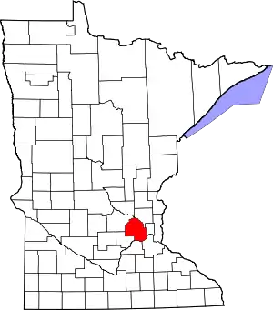 Map of Minnesota highlighting Hennepin County |
| Unincorporated areas | ||
| Footnotes | ‡This populated place also has portions in an adjacent county or counties | |
| ||

| Authority control |
|---|