Minnesota State Highway 264
Minnesota State Highway 264 (MN 264) is a 7.394-mile-long (11.899 km) highway in southwest Minnesota, which runs from its intersection with Nobles County State-Aid Highway 21 (2nd Avenue) in Round Lake and continues north to its northern terminus at its interchange with Interstate 90 and Jackson County State-Aid Highway 1, six miles east of Worthington.
| ||||
|---|---|---|---|---|
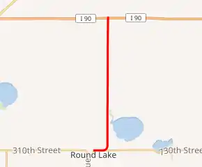
MN 264 highlighted in red | ||||
| Route information | ||||
| Defined by MS § 161.115(195) | ||||
| Maintained by MnDOT | ||||
| Length | 7.394 mi[1] (11.899 km) | |||
| Existed | July 1, 1949[2]–present | |||
| Major junctions | ||||
| South end | ||||
| North end | ||||
| Location | ||||
| Counties | Nobles, Jackson | |||
| Highway system | ||||
| ||||

Route description
Highway 264 serves as a north–south connector route in southwest Minnesota between Round Lake and Interstate 90.
The route runs along the county line for Nobles and Jackson counties for most of its length.
Highway 264 follows Amy Avenue and Main Street in Round Lake.
The route is legally defined as Route 264 in the Minnesota Statutes.[3]
Major intersections
| County | Location | mi[1] | km | Destinations | Notes |
|---|---|---|---|---|---|
| Nobles | Round Lake | 0.000 | 0.000 | ||
| Indian Lake Township | 0.991 | 1.595 | |||
| Nobles–Jackson county line | Lorain–Ewington township line | 5.794 | 9.325 | ||
| 7.245– 7.394 | 11.660– 11.899 | Continues as CSAH 1 north of I-90 | |||
| 1.000 mi = 1.609 km; 1.000 km = 0.621 mi | |||||
References
- "Trunk Highway Logpoint Listing - Construction District 7" (PDF). Minnesota Department of Transportation. September 4, 2009. Archived from the original (PDF) on December 4, 2008. Retrieved 2010-05-29.
- "Chapter 663-H.F. No. 1792", Session Laws of Minnesota for 1949, Earl L. Berg, Commissioner of Administration, pp. 1177–1185
- "161.115, Additional Trunk Highways". Minnesota Statutes. Office of the Revisor of Statutes, State of Minnesota. 2010. Retrieved January 21, 2011.
- 1954 Official Road Map of Minnesota (Map). Cartography by The H.M. Gousha Company. Minnesota Department of Highways. January 1, 1954. § E20. Archived from the original on August 25, 2011. Retrieved January 21, 2011.
- 1956 Official Road Map of Minnesota (Map). Cartography by The H.M. Gousha Company. Minnesota Department of Highways. 1956. § E20. Archived from the original on August 25, 2011. Retrieved January 21, 2011.
*MnDOT. Nobles County General Highway Map. Accessed May 2, 2010. *MnDOT. Jackson County General Highway Map. Accessed May 2, 2010.