Nobles County, Minnesota
Nobles County is a county in the U.S. state of Minnesota. As of the 2010 United States Census, the population was 21,378.[1] Its county seat is Worthington.[2]
Nobles County | |
|---|---|
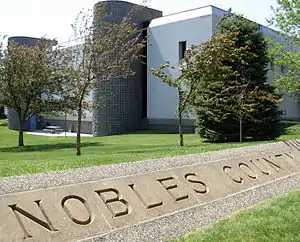 Nobles County Government Center in Worthington | |
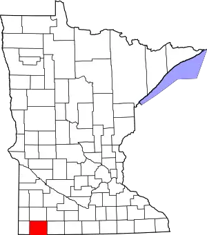 Location within the U.S. state of Minnesota | |
 Minnesota's location within the U.S. | |
| Coordinates: 43°40′N 95°46′W | |
| Country | |
| State | |
| Founded | May 23, 1857 (created) October 27, 1870 (organized) |
| Named for | William H. Nobles |
| Seat | Worthington |
| Largest city | Worthington |
| Area | |
| • Total | 723 sq mi (1,870 km2) |
| • Land | 715 sq mi (1,850 km2) |
| • Water | 7.5 sq mi (19 km2) 1.0%% |
| Population (2010) | |
| • Total | 21,378 |
| • Estimate (2019) | 21,629 |
| • Density | 30.7/sq mi (11.9/km2) |
| Time zone | UTC−6 (Central) |
| • Summer (DST) | UTC−5 (CDT) |
| Congressional district | 1st |
| Website | www |
Nobles County comprises the Worthington, MN Micropolitan Statistical Area. Nobles County in May 2020 had the fourth-highest per capita COVID-19 infection rate of any American county. About one of every 17 residents has tested positive, with 1319 cases. Most were connected to the large JBS meatpacking plant in Worthington.[3][4]
History

Nobles County was first occupied by the Sisseton Sioux. The first white man to set foot on the land was Joseph Nicollet who came to map out the area in 1842. Nicollet named Lake Okabena (there were two Lake Okabenas at the time), Lake Ocheda, East and West Graham Lake and the Kanaranzi Creek.
The first settlement was near Graham Lakes in 1846. Nobles County was established May 23, 1857, and organized October 27, 1870.[6] The county was named for William H. Nobles, a member of the Minnesota territorial legislature in 1854 and 1856. In Autumn 1856 he began the construction of a wagon road for the US government, crossing southwestern Minnesota and Nobles County, to extend from Fort Ridgely to South Pass in the Rocky Mountains. This work was continued in 1857 but was not completed.[7] Nobles County was created by the Minnesota Territory legislature just before the full force of the Panic of 1857 was felt. Settlers were further discouraged from coming by the Spirit Lake Massacre of 1857, where a band of Sioux murdered settlers in Spirit Lake and along the Des Moines River in Jackson and Cottonwood Counties. The few whites in the area were understandably reluctant to stay.
During the summer of 1867, a mail route was established from Blue Earth through the Graham Lakes settlement to Yankton, South Dakota. In January, a Post Office was established in each settlement. The population in the spring of 1870 was 117 and nearly doubled by fall. County Government did not start until 1870. The first railroad, the St. Paul & Sioux City Railway, was built in 1871. This later became the Chicago Northwestern Railroad, and is now operated by the Union Pacific Railroad.
In 1871, a group of men from Toledo, Ohio organized a company to locate a colony of settlers in some western county. After traveling 20,000 miles in the Midwest, they decided on Nobles County and by the spring of 1872, hundreds of people came in and took up land. Worthington was platted in 1871,[8] and became the county seat in 1873. The Worthington & Sioux Falls Railway was established in 1876. This led to rapid settlement in Rushmore, Adrian, and the western portions of the county.
The 1860 census of Nobles County showed 11 families, 35 persons, (3 from Norway, 3 from Bavaria, 1 from Ireland and the rest from the eastern states).[9] In 1880, the population was 4,435. In 1895, the population was 11,905, and in 1970, the population was up to 23,208. In 2000, the population was 20,832, and the 2010 census showed a population of 21,378.[10]
COVID-19 pandemic (2020)
In May 2020, Nobles County had the fourth-highest per capita COVID-19 infection rate of any county in the United States. About one of every 17 residents had tested positive, with 1319 cases.[3][4]
- By November 20, 2020, they had 2,887 cases and 27 deaths.
Economy
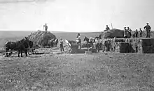
This county has farming and meat packing.
Geography
Nobles County is on the south side of Minnesota. Its south border abuts the north border of the state of Iowa.[12] The county has a total area of 723 square miles (1,870 km2), of which 715 square miles (1,850 km2) is land and 7.5 square miles (19 km2) (1.0%) is water.[13]
Major highways
Adjacent counties
- Murray County - north
- Cottonwood County - northeast
- Jackson County - east
- Osceola County, Iowa - southeast
- Lyon County, Iowa - southwest
- Rock County - west
Lakes[12]
- East Graham Lake
- Fulda First Lake
- Indian Lake
- Iowa Lake (part)
- Jack Lake
- Kinbrae Lake
- Lake Bella
- Lake Ocheda
- Lake Okabena
- West Graham Lake
- Willow Lake (part)
Protected areas[12]
- Adrian Spring County Park
- Aid Pit State Wildlife Management Area
- Bigelow State Wildlife Management Area
- Champepadan State Wildlife Management Area
- Compass Prairie Scientific and Natural Area
- Dewald State Wildlife Management Area
- Eagle Lake State Wildlife Management Area
- Ells Pit State Wildlife Management Area
- Fenmont State Wildlife Management Area
- Fulda State Wildlife Management Area
- Fury State Wildlife Management Area
- Groth State Wildlife Management Area
- Hawkeye County Park
- John Erickson State Wildlife Management Area
- Lake Bella State Wildlife Management Area
- Lake Ocheda Game Refuge
- Lone Tree State Wildlife Management Area
- Maka-Oicu County Park
- Midway County Park
- Peterson State Wildlife Management Area
- Pheasant Run State Wildlife Management Area
- Scheuring State Wildlife Management Area
- Schweigert State Wildlife Management Area
- Sherwood State Wildlife Management Area
- Sportsman County Park
- Swessinger State Wildlife Management Area
- West Graham State Wildlife Management Area
Geology
Nobles County sits atop the Buffalo Ridge, a large expanse of rolling hills in southwestern Minnesota reaching a height of 1,995' (608m) ASL. The Buffalo Ridge marks the most southerly extent of the last glaciation, and extends 60 miles (96 km) through Lincoln, Lyon, Pipestone, Murray, Rock, and Nobles counties. It is a drainage divide separating the watersheds of the Mississippi and Missouri Rivers. Because of its elevation and constant winds, Buffalo Ridge has become a major site for wind energy. Over 200 wind turbines stand along the Ridge.
Buffalo Ridge is part of the inner coteau and is the highest point of the Coteau des Prairies in Minnesota.[14] Its bedrock is formed of Cretaceous shale, sandstone and clay that lie above the pinkish-red Upper Precambrian Sioux Quartzite.[15] These units are covered in most areas by thick deposits of glacial drift, which consist of up to 800' (244m) of pre-Wisconsin age glacial till left after the glaciers receded. The inner coteau is made up of extremely stream-eroded glacial deposits of pre-Wisconsin glacial drift, which is then covered by a 6-15' (1.8-4.6m) thick deposit of a wind-blown silt called loess.[14] This covering results in the creation of an area with long, gently sloping hills. Loess is an easily eroded material, resulting in few lakes and wetlands in the inner coteau area. Loess however promotes well-established dendritic drainage networks flowing into the Missouri River and Minnesota River systems.
Demographics
| Historical population | |||
|---|---|---|---|
| Census | Pop. | %± | |
| 1860 | 35 | — | |
| 1870 | 117 | 234.3% | |
| 1880 | 4,435 | 3,690.6% | |
| 1890 | 7,958 | 79.4% | |
| 1900 | 14,932 | 87.6% | |
| 1910 | 15,210 | 1.9% | |
| 1920 | 17,917 | 17.8% | |
| 1930 | 18,618 | 3.9% | |
| 1940 | 21,215 | 13.9% | |
| 1950 | 22,435 | 5.8% | |
| 1960 | 23,365 | 4.1% | |
| 1970 | 23,208 | −0.7% | |
| 1980 | 21,840 | −5.9% | |
| 1990 | 20,098 | −8.0% | |
| 2000 | 20,832 | 3.7% | |
| 2010 | 21,378 | 2.6% | |
| 2019 (est.) | 21,629 | [16] | 1.2% |
| US Decennial Census[17] 1790-1960[18] 1900-1990[19] 1990-2000[20] 2010-2019[1] | |||
2000 census
As of the 2000 United States Census, there were 20,832 people, 7,939 households, and 5,517 families in the county. The population density was 29.1/sqmi (11.2/km2). There were 8,465 housing units at an average density of 11.8/sqmi (4.57/km2). The racial makeup of the county was 86.50% White, 1.07% Black or African American, 0.31% Native American, 3.98% Asian, 0.07% Pacific Islander, 6.64% from other races, and 1.43% from two or more races. 11.16% of the population were Hispanic or Latino of any race. 47.0% were of German, 8.3% Dutch and 8.0% Norwegian ancestry.
There were 7,939 households, out of which 32.10% had children under the age of 18 living with them, 58.80% were married couples living together, 6.90% had a female householder with no husband present, and 30.50% were non-families. 26.50% of all households were made up of individuals, and 14.10% had someone living alone who was 65 years of age or older. The average household size was 2.58 and the average family size was 3.11.
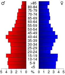
The county population contained with 26.50% under the age of 18, 8.20% from 18 to 24, 26.60% from 25 to 44, 21.30% from 45 to 64, and 17.40% who were 65 years of age or older. The median age was 38 years. For every 100 females there were 99.50 males. For every 100 females age 18 and over, there were 98.40 males.
The median income for a household in the county was $35,684, and the median income for a family was $43,076. Males had a median income of $27,853 versus $20,346 for females. The per capita income for the county was $16,987. About 8.20% of families and 11.70% of the population were below the poverty line, including 15.30% of those under age 18 and 12.50% of those age 65 or over.
Communities
Cities[8]
Census-designated place
Unincorporated communities[8]
- Org (named Sioux Falls Junction until 1890)
- Pfingsten
- Ransom
- Reading
- St. Kilian
Townships
- Bigelow Township
- Bloom Township
- Dewald Township
- Elk Township
- Graham Lakes Township
- Grand Prairie Township
- Hersey Township
- Indian Lake Township
- Larkin Township
- Leota Township
- Lismore Township
- Little Rock Township
- Lorain Township
- Olney Township
- Ransom Township
- Seward Township
- Summit Lake Township
- Westside Township
- Wilmont Township
- Worthington Township
Politics
Nobles County voters have tended to vote Republican in the past several decades. In 67% of national elections since 1980 the county selected the Republican Party candidate (as of 2016).
| Year | Republican | Democratic | Third parties |
|---|---|---|---|
| 2016 | 61.4% 5,299 | 31.7% 2,733 | 7.0% 600 |
| 2012 | 53.8% 4,581 | 44.5% 3,793 | 1.7% 146 |
| 2008 | 49.6% 4,368 | 48.2% 4,244 | 2.3% 201 |
| 2004 | 56.1% 5,159 | 42.4% 3,898 | 1.6% 147 |
| 2000 | 53.7% 4,766 | 42.4% 3,760 | 3.9% 346 |
| 1996 | 41.6% 3,769 | 45.3% 4,106 | 13.1% 1,186 |
| 1992 | 35.7% 3,548 | 37.8% 3,756 | 26.4% 2,626 |
| 1988 | 46.3% 4,348 | 52.7% 4,953 | 1.0% 93 |
| 1984 | 50.8% 4,876 | 48.1% 4,619 | 1.2% 110 |
| 1980 | 45.4% 4,706 | 45.4% 4,703 | 9.2% 956 |
| 1976 | 42.0% 4,503 | 56.2% 6,034 | 1.8% 198 |
| 1972 | 47.0% 4,951 | 51.9% 5,464 | 1.1% 110 |
| 1968 | 44.0% 4,451 | 51.2% 5,171 | 4.8% 485 |
| 1964 | 35.3% 3,517 | 64.6% 6,431 | 0.1% 12 |
| 1960 | 53.2% 5,636 | 46.7% 4,947 | 0.1% 11 |
| 1956 | 56.2% 5,196 | 43.7% 4,036 | 0.1% 9 |
| 1952 | 65.3% 6,340 | 34.5% 3,351 | 0.3% 26 |
| 1948 | 38.2% 3,203 | 60.7% 5,090 | 1.1% 89 |
| 1944 | 54.6% 4,149 | 44.9% 3,413 | 0.5% 35 |
| 1940 | 56.3% 5,104 | 43.3% 3,919 | 0.4% 36 |
| 1936 | 32.2% 2,601 | 60.9% 4,919 | 6.8% 552 |
| 1932 | 35.4% 2,417 | 63.5% 4,343 | 1.1% 78 |
| 1928 | 56.0% 3,676 | 43.6% 2,862 | 0.4% 25 |
| 1924 | 46.1% 2,835 | 6.9% 421 | 47.1% 2,894 |
| 1920 | 79.6% 4,420 | 17.7% 982 | 2.7% 148 |
| 1916 | 50.4% 1,413 | 45.7% 1,280 | 4.0% 111 |
| 1912 | 20.8% 605 | 34.2% 994 | 45.1% 1,312 |
| 1908 | 56.8% 1,432 | 36.7% 925 | 6.5% 165 |
| 1904 | 70.5% 1,732 | 25.3% 622 | 4.2% 102 |
| 1900 | 57.7% 1,709 | 37.2% 1,101 | 5.2% 153 |
| 1896 | 54.8% 1,568 | 42.1% 1,204 | 3.0% 87 |
| 1892 | 44.2% 894 | 32.9% 664 | 22.9% 463 |
References
- "State & County QuickFacts". United States Census Bureau. Archived from the original on June 7, 2011. Retrieved September 1, 2013.
- "Find a County". National Association of Counties. Archived from the original on May 31, 2011. Retrieved June 7, 2011.
- See "Coronavirus in the U.S.: Latest Map and Case Count" The New York Times May 15, 2020.
- See Joe Barrett, "Coronavirus Threatens a Minnesota Farm Town’s Economic Engine: JBS meatpacking plant turned Worthington into a global melting pot; now officials worry as it reopens" Wall Street Journal May 22, 2020
- Nelson, Steven (2011). Savanna Soils of Minnesota. Minnesota: Self. pp. 69-70. ISBN 978-0-615-50320-2.
- "Minnesota Place Names". Minnesota Historical Society. Retrieved March 18, 2014.
- "Warren Upham's Minnesota Places: A Geographical Encyclopedia". Archived from the original on June 20, 2007. Retrieved October 10, 2018.
- Upham, Warren. Minnesota Geographic Names, pp. 376-79. Accessed 17 March 2019
- US Census Bureau: 1860 Census (accessed March 17, 2019)
- "Archived copy". Archived from the original on January 11, 2011. Retrieved June 11, 2010.CS1 maint: archived copy as title (link) Nobles County Government Website
- The Geology of Minnesota Archived July 24, 2011, at the Wayback Machine
- Nobles County MN Google Maps (accessed 17 March 2019)
- "2010 Census Gazetteer Files". US Census Bureau. August 22, 2012. Archived from the original on September 21, 2013. Retrieved October 24, 2014.
- DNR, Minnesota DNR, http://www.dnr.state.mn.us/ecs/251Bc/index.html.
- Anderson RR (1987) Precambrian Sioux Quartzite at Gitchie Manitou State Preserve, Iowa. Centennial Field Guide Vol. 3: North-Central Section of the Geological Society of America: Vol. 3, No. 0 pp. 77–80.
- "Population and Housing Unit Estimates". Retrieved March 26, 2020.
- "US Decennial Census". US Census Bureau. Archived from the original on April 26, 2015. Retrieved October 24, 2014.
- "Historical Census Browser". University of Virginia Library. Retrieved October 24, 2014.
- "Population of Counties by Decennial Census: 1900 to 1990". US Census Bureau. Retrieved October 24, 2014.
- "Census 2000 PHC-T-4. Ranking Tables for Counties: 1990 and 2000" (PDF). US Census Bureau. Retrieved October 24, 2014.
- Leip, David. "Atlas of US Presidential Elections". uselectionatlas.org. Retrieved October 10, 2018.
External links
Places adjacent to Nobles County, Minnesota | ||||||||||
|---|---|---|---|---|---|---|---|---|---|---|
| ||||||||||
Municipalities and communities of Nobles County, Minnesota, United States | ||
|---|---|---|
| Cities | Map of Minnesota highlighting Nobles County | |
| Townships | ||
| CDP | ||
| Unincorporated communities | ||
| ||

| Authority control |
|---|