Interstate 90 in Minnesota
Interstate 90 (I-90) in the U.S. state of Minnesota runs for 276 miles (444 km) across the southern side of the state, parallel to the Iowa state line. The route connects the cities of Rochester, Worthington, Albert Lea, and Austin. The city of Winona is also in close proximity to I-90, with about 10 miles (16 km) between the Interstate and the city.
| ||||
|---|---|---|---|---|
| American Veterans Memorial Highway | ||||

I-90 highlighted in red | ||||
| Route information | ||||
| Maintained by MnDOT | ||||
| Length | 275.70 mi[1] (443.70 km) | |||
| Major junctions | ||||
| West end | ||||
| East end | ||||
| Location | ||||
| Counties | Rock, Nobles, Jackson, Martin, Faribault, Freeborn, Mower, Olmsted, Winona | |||
| Highway system | ||||
| ||||

Route description
I-90 enters the state from South Dakota near Beaver Creek. This part of Minnesota has flat to gently rolling terrain and is the beginnings of corn belt farmland. The flat terrain is often subject to blowing and drifting snow in colder months, and the western portions of the highway are closed multiple times each winter.
Rock County, where I-90 enters Minnesota, is one of the only counties in the state lacking a natural lake. The change from semi-arid to a wetter climate happens slowly moving eastbound on I-90 through southern Minnesota. The route passes through the cities of Luverne, Adrian, Worthington, Jackson, Fairmont, and Blue Earth. I-90 has an interchange with I-35 at Albert Lea.
East of the city of Austin, I-90 changes direction slightly and heads towards Rochester, and the route enters a much more hilly landscape. This is the driftless area of southeast Minnesota. Unlike the rest of the state, where the most recent glaciations left terrain that is either flat or rolling under a deposit of glacial till, this area escaped the most recent glaciation. The bedrock to the top of the I-90 road cuts is noticeable at this point. The other notable feature of this area are deep, steep valleys cut by water that poured through this area as the ice cap melted.
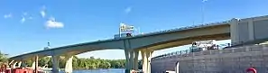
I-90 drops into the scenic Mississippi River valley just west of Dresbach. The carriageways split apart as they descend, and they rejoin west of the junction with U.S. Highway 61. I-90 then parallels the Mississippi River before turning east and crossing the Dresbach Bridge over the River into Wisconsin.
I-90 is atypical in that just across the Minnesota–Wisconsin state line, (immediately west of the community of Dakota) the median is wide enough that farms exist between the road beds.[2]
Legally, the Minnesota section of Interstate 90 is defined as unmarked Legislative Route 391 in the Minnesota Statutes. Interstate 90 is not marked with this legislative number along the actual highway.
History
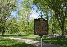
Interstate 90 in Minnesota was authorized as part of the original interstate network in 1956. The first section of I-90 in Minnesota constructed was the bypass of Austin in 1961.[3] The wayside rest area near Blue Earth, Minnesota, is where the east-building I-90 and west-building I-90 teams linked up in 1978, thus completing construction in Minnesota and joining the 3,099.07 miles of the interstate.[4] Plaques dedicating the pavement completion and describing the significance of this segment are on display at the rest area.[5]
I-90 in Minnesota closely follows the route of old U.S. Highway 16 over most of its route except from just east of Austin, where I-90 turns toward Rochester and is constructed on a new alignment not previously covered by a highway. The section of I-90 east of Rochester was constructed just south of U.S. Highway 14 and south of the city of Winona.
I-90 served as a replacement for old U.S. 16 between the South Dakota state line and I-90's interchange with present-day State Highway 16 at Dexter.
Exit list
| County | Location | mi[6] | km | Exit | Destinations | Notes |
|---|---|---|---|---|---|---|
| Rock | | 0.000 | 0.000 | Continuation into South Dakota | ||
| | 1.057 | 1.701 | 1 | Also leads to Manley one mile (1.6 km) to the south | ||
| Beaver Creek | 3.895 | 6.268 | 3 | Eastbound exit and westbound entrance | ||
| 5.074 | 8.166 | 5 | ||||
| Luverne | 12.479 | 20.083 | 12 | Also access to Pipestone | ||
| Magnolia | 18.483 | 29.746 | 18 | |||
| Nobles | Adrian | 26.620 | 42.841 | 26 | ||
| Rushmore | 33.707 | 54.246 | 33 | |||
| Worthington | 42.255 | 68.003 | 42 | Road from exit into Wilmont was formerly MN 266 | ||
| 43.739 | 70.391 | 43 | Also access to Fulda | |||
| 45.148 | 72.659 | 45 | Also access to Mankato, Sioux City, Twin Cities | |||
| | 47.796 | 76.920 | 47 | Eastbound exit and westbound entrance | ||
| Nobles–Jackson county line | | 50.738 | 81.655 | 50 | ||
| Jackson | | 57.728 | 92.904 | 57 | ||
| | 64.767 | 104.232 | 64 | |||
| Jackson | 73.813 | 118.791 | 73 | |||
| Alpha | 80.083 | 128.881 | 80 | |||
| Martin | Sherburn | 87.309 | 140.510 | 87 | ||
| Welcome | 93.675 | 150.755 | 93 | |||
| Fairmont | 99.807 | 160.624 | 99 | |||
| 102.053 | 164.238 | 102 | Also access to Mankato, Twin Cities | |||
| Granada | 107.202 | 172.525 | 107 | Road from exit into Granada was formerly MN 262 | ||
| Faribault | Guckeen | 113.272 | 182.294 | 113 | ||
| Blue Earth | 119.909 | 192.975 | 119 | Green Giant | ||
| | 128.538 | 206.862 | 128 | |||
| | 134.546 | 216.531 | 134 | |||
| | 138.630 | 223.103 | 138 | |||
| Freeborn | Alden | 146.292 | 235.434 | 146 | ||
| Albert Lea | 154.739 | 249.028 | 154 | |||
| 157.826 | 253.996 | 157 | ||||
| 159.740 | 257.077 | 159 | Signed as exits 159A (south) and 159B (north); I-35 exits 13A-B | |||
| Hayward | 163.705 | 263.458 | 163 | |||
| Oakland | 166.321 | 267.668 | 166 | |||
| Mower | Austin | 175.488 | 282.421 | 175 | ||
| 177.188 | 285.156 | 177 | West end of US 218 overlap | |||
| 177.872 | 286.257 | 178A | 4th Street NW – Austin | |||
| 178.506 | 287.278 | 178B | 6th Street NE – Austin | |||
| 179.148 | 288.311 | 179 | 11th Drive NE – Austin | |||
| 179.741 | 289.265 | 180A | Westbound exit and eastbound entrance | |||
| 180.024 | 289.721 | 180B | East end of US 218 overlap | |||
| 180.500 | 290.487 | 181 | 28th Street NE – Austin | |||
| | 183.562 | 295.414 | 183 | |||
| | 187.338 | 301.491 | 187 | |||
| | 189.584 | 305.106 | 189 | |||
| Dexter | 193.048 | 310.681 | 193 | |||
| Olmsted | | 205.054 | 330.002 | 205 | ||
| Stewartville | 209.270 | 336.787 | 209 | Signed as exits 209A (south/east) and 209B (north/west) | ||
| Rochester | 217.620 | 350.225 | 218 | Also access to Twin Cities; Chatfield only appears on eastbound signage, Rochester only appears on westbound signage | ||
| Eyota | 223.606 | 359.859 | 224 | |||
| Dover | 228.572 | 367.851 | 229 | |||
| Winona | St. Charles | 232.291 | 373.836 | 233 | ||
| | 242.061 | 389.559 | 242 | |||
| | 249.103 | 400.892 | 249 | West end of MN 43 overlap | ||
| Winona | 252.059 | 405.650 | 252 | East end of MN 43 overlap | ||
| | 257.692 | 414.715 | 257 | |||
| Nodine | 266.017 | 428.113 | 267 | |||
| | 270.288 | 434.986 | 269 | Westbound access to US 14 west/US 61 north; west end of US 14 / US 61 overlap; eastbound exit via exit 270 | ||
| Dakota | 271.232 | 436.506 | 270 | US 14 and US 61 signed eastbound only; westbound entrance via exit 269 | ||
| Dresbach | 272.663– 272.681 | 438.809– 438.838 | 273 | Dresbach | Signed as exits 273A (first exit) and 273B (second exit) eastbound | |
| La Crescent | 275.243 | 442.961 | 276 | East end of US 14 / US 61 overlap | ||
| Mississippi River | 275.701 | 443.698 | I-90 Mississippi River Bridge | |||
| Continuation into Wisconsin | ||||||
1.000 mi = 1.609 km; 1.000 km = 0.621 mi
| ||||||
References
| Wikimedia Commons has media related to Interstate 90 in Minnesota. |
*Steve Riner Details of Routes 76 to 100. Unofficial Minnesota Highways Page. Accessed January 12, 2009.
- "Route Log- Main Routes of the Eisenhower National System of Interstate and Defense Highways - Table 1". Federal Highway Administration. Retrieved 4 October 2014.
- Google (June 8, 2009). "Interstate 90 in Minnesota" (Map). Google Maps. Google. Retrieved June 8, 2009.
- "Construction Project Log Record" (PDF). Archived from the original (pdf) on 2012-09-13. Retrieved 2013-01-29.
- "MINNESOTA HIGHWAYS" (PDF). Archived from the original (PDF) on 2013-06-04. Retrieved 2013-01-29.
- A Golden Dedication for I-90 (Minnesota Historical Marker). Minnesota Historical Society; Minnesota Department of Transportation. Retrieved July 7, 2016.
- Minnesota Department of Transportation (August 14, 2014). "Statewide Trunk Logpoint Listing" (PDF). St. Paul: Minnesota Department of Transportation. Retrieved 2015-07-05.
| Previous state: South Dakota |
Minnesota | Next state: Wisconsin |