Scott County, Minnesota
Scott County is a county in the U.S. state of Minnesota. As of the 2010 census, the population was 129,928.[3] Its county seat is Shakopee.[4] Shakopee is also the largest city in Scott County, the twenty-third-largest city in Minnesota, and the sixteenth-largest Twin Cities suburb. The county was organized in 1853 and named in honor of General Winfield Scott. Scott County is part of the Minneapolis-St. Paul-Bloomington, MN-WI Metropolitan Statistical Area. It is a member of the Metropolitan Council, and shares many of the council's concerns about responsible growth management, advocating for progressive development concepts such as clustering, open-space design, and the preservation of open space and rural/agricultural land.
Scott County | |
|---|---|
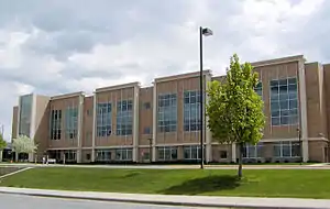 Scott County Government Center | |
Logo | |
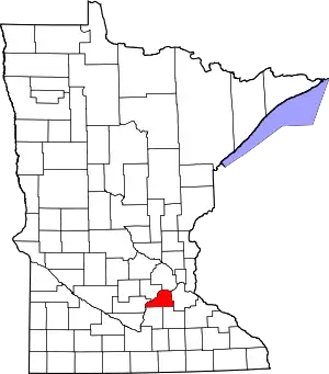 Location within the U.S. state of Minnesota | |
 Minnesota's location within the U.S. | |
| Coordinates: 44°39′N 93°32′W | |
| Country | |
| State | |
| Founded | March 5, 1853[1] |
| Named for | Winfield Scott[2] |
| Seat | Shakopee |
| Largest city | Shakopee |
| Area | |
| • Total | 368 sq mi (950 km2) |
| • Land | 356 sq mi (920 km2) |
| • Water | 12 sq mi (30 km2) 3.2%% |
| Population (2010) | |
| • Total | 129,928 |
| • Estimate (2020) | 151,643 |
| • Density | 364/sq mi (141/km2) |
| Time zone | UTC−6 (Central) |
| • Summer (DST) | UTC−5 (CDT) |
| Congressional district | 2nd |
| Website | www |
The Shakopee-Mdewakanton Indian Reservation is entirely within the county and within the cities of Prior Lake and Shakopee. Due to its proximity to major cities, the tribe has earned revenues at its gaming casinos and hotel; it has used funds to reinvest in economic development for the tribe, founding numerous other enterprises. The tribe is also committed to philanthropy, having donated more than $350 million to organizations and causes in Scott County and across the country.[5]
Scott County was one of Minnesota's fastest-growing counties, having increased 55% since 1990. However, according to US Census data released in 2011, Scott County saw the steepest drop in median income of all of Minnesota's populous counties.[6] Scott County is 365 square miles (950 km2) and is bounded on the west and north by the Minnesota River.
The Minnesota River had supported the county's fur trading, lumbering, and farming industries in the 19th century. Today, Scott County experiences a growing mix of commercial, industrial, and housing development, but is still primarily rural. Scott County is home to several historical, scenic, and entertainment destinations including Canterbury Park, The Landing, Elko Speedway, Mystic Lake Casino run by the Shakopee-Mdewakanton Dakota; the Renaissance Festival, and Valleyfair Amusement Park.
History
Scott County was first inhabited by two bands of the Santee Sioux (Dakota) Indians, the Mdewakanton and Wahpeton. Their semi-nomadic life followed a seasonal cycle. They gathered food, hunted, fished, and planted corn. In the summer the Dakota villages were occupied but in the winter the groups separated for hunting. They had many permanent villages along the Minnesota River. They had many trails leading to these settlements and to the Red River Valley in the North, and the Prairie du Chien to the Southeast. These trails were later used by the fur traders and settlers, and were known as the "ox cart trails." The area of Scott County, as well as much of southern Minnesota, was opened for settlement by two treaties signed at Mendota and Traverse des Sioux, in 1851 and 1853. These treaties removed the Dakota Indians to reservations in upper Minnesota.
Scott County was established and organized by an Act passed in the legislature on March 5, 1853. The 369-square-mile (960 km2) county was named after General Winfield Scott. Settlers started entering the area in the mid-1850s. The Minnesota River and the ox cart trails were the primary transportation routes. The first settlers were Yankees, followed by groups of Germans, Irish, Czechs, and Scandinavians. They each brought their own traditions and religions. Most of these settlers became farmers. Fur trading, lumbering, and farming were Minnesota's major industries all throughout the 19th century. With the fast-growing farms, sprang up towns. Shakopee, the County Seat, began in 1851 as a trading post by the Dakota Village of Chief Shakopee (or Shakpay). Other towns were established alongside transportation routes. When the railroads came to Minnesota, they became the primary mode of transportation, and eventually highways were developed along the ox cart trails between the communities.
Due to urban sprawl and suburbanization this rural county is changing dramatically. Cities are continually growing, causing an increase in population from roughly 90,000 in 2000 to 130,000 today, making Scott County Minnesota's fastest-growing county.
Geography
According to the U.S. Census Bureau, the county has an area of 368 square miles (950 km2), of which 356 square miles (920 km2) is land and 12 square miles (31 km2) (3.2%) is water.[8] It is the third-smallest county in Minnesota by land area and second-smallest by total area.
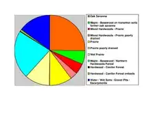
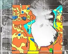
The Minnesota River is the county's boundary in both the north and the west. The broad river valley juts through glacial sediment into some of the oldest rock known. Now mostly farmland, it was an oak savanna and a mixture of grass and clusters of trees that grew parallel to the river valley. The savanna bordered the "Big Woods", a "closed-forest savanna" that covered most of Minnesota before it was logged in the mid-19th century. Scott is one of 17 Minnesota savanna counties with more savanna soils than either forest or prairie soils. One example of native vegetation in Scott County:
Lakes
- Ahlswede Lake: in St. Lawrence Township
- Blue Lake: in Jackson Township
- Browns Lake: in St. Lawrence Township
- Campbell Lake: in Spring Lake Township
- Cedar Lake: western two-thirds is in Helena Township; eastern third is in Cedar Lake Township
- Cedar Lake: there is a smaller Cedar Lake in the eastern part of Cedar Lake Township
- Clark Lake: in Blakely Township
- Cleary Lake: mostly in Credit River Township; the western part stretches into Spring Lake Township
- Crystal Lake: in Spring Lake Township
- Cynthia Lake: northern two thirds is in Spring Lake Township; the rest is in Cedar Township
- Deans Lake: in Jackson Township
- Fish Lake: in Spring Lake Township
- Fisher Lake: in Jackson Township
- Gifford Lake: in Jackson Township
- Hanrahan Lake: in Jackson Township
- Hickey Lake: eastern two thirds is in Helena Township; western third is in Cedar Lake Township
- Horseshoe Lake: in St. Lawrence Township
- Howard Lake: in Jackson Township
- Kane Lake: in Spring Lake Township
- Lennon Lake: in Cedar Lake Township
- Lower Prior Lake: in the city of Prior Lake
- Markley Lake: eastern half is in Credit River Township; the western half is in Prior Lake
- McMahon Lake: in Spring Lake Township
- Mud Lake: in Cedar Lake Township
- Murphy Lake: in Credit River Township
- O'Dowd Lake: western third is in Louisville Township; eastern two thirds is in Jackson Township
- Pike Lake: in Jackson Township
- Pleasant Lake: in Helena Township
- Rice Lake: west half is in Cedar Lake Township; east half is in Dakota County
- Rice Lake: there is another Rice Lake in Jackson Township
- Rice Lake: there is a third Rice Lake in Spring Lake Township
- Schneider Lake: in Louisville Township
- Spring Lake: in Spring Lake Township and Prior Lake
- St. Catherine Lake: in Cedar Lake Township
- Thole Lake: in Louisville Township
- Upper Prior Lake: in Prior Lake
Major highways
 Interstate 35
.svg.png.webp) U.S. Highway 169
U.S. Highway 169 Minnesota State Highway 13
 Minnesota State Highway 19
 Minnesota State Highway 21
 Minnesota State Highway 25
 Minnesota State Highway 41
 Minnesota State Highway 282
.svg.png.webp) County Road 42
County Road 42.svg.png.webp) County Road 101
County Road 101- Other County Roads
Adjacent counties
- Hennepin County (north)
- Dakota County (east)
- Rice County (southeast)
- Le Sueur County (southwest)
- Sibley County (west)
- Carver County (northwest)
National protected area
Demographics
| Historical population | |||
|---|---|---|---|
| Census | Pop. | %± | |
| 1860 | 4,595 | — | |
| 1870 | 11,042 | 140.3% | |
| 1880 | 13,516 | 22.4% | |
| 1890 | 13,831 | 2.3% | |
| 1900 | 15,147 | 9.5% | |
| 1910 | 14,888 | −1.7% | |
| 1920 | 14,245 | −4.3% | |
| 1930 | 14,116 | −0.9% | |
| 1940 | 15,585 | 10.4% | |
| 1950 | 16,486 | 5.8% | |
| 1960 | 21,909 | 32.9% | |
| 1970 | 32,423 | 48.0% | |
| 1980 | 43,784 | 35.0% | |
| 1990 | 57,846 | 32.1% | |
| 2000 | 89,498 | 54.7% | |
| 2010 | 129,928 | 45.2% | |
| 2020 (est.) | 151,643 | [9] | 16.7% |
| U.S. Decennial Census[10] 1790-1960[11] 1900-1990[12] 1990-2000[13] 2010-2019[3] | |||

As of the 2000 census, the county had 89,498 people, 30,692 households, and 23,970 families. The population density was 251 people per square mile (97/km2). There were 31,609 housing units at an average density of 89 per square mile (34/km2). The county's racial makeup was 93.65% White, 0.92% Black or African American, 0.77% Native American, 2.17% Asian, 0.03% Pacific Islander, 1.24% from other races, and 1.21% from two or more races. 2.66% of the population were Hispanic or Latino of any race. 39.6% were of German, 12.6% Norwegian, 8.3% Irish and 5.1% Swedish ancestry.
There were 30,692 households, of which 45.40% had children under the age of 18 living with them, 66.90% were married couples living together, 7.40% had a female householder with no husband present, and 21.90% were non-families. 16.00% of all households were made up of individuals, and 4.50% had someone living alone who was 65 years of age or older. The average household size was 2.89 and the average family size was 3.25.
31.20% of the county's population was under age 18, 6.70% was from age 18 to 24, 37.30% was from age 25 to 44, 18.60% was from age 45 to 64, and 6.20% was age 65 or older. The median age was 33 years. For every 100 females there were 101.90 males. For every 100 females age 18 and over, there were 100.00 males.
The county's median household income was $66,612, and the median family income was $72,212 (these figures had risen to $80,968 and $90,489 respectively as of a 2007 estimate). Males had a median income of $46,593 versus $32,482 for females. The county's per capita income was $26,418. About 2.00% of families and 3.40% of the population were below the poverty line, including 3.40% of those under age 18 and 7.50% of those age 65 or over. However, in 2011, Scott County saw the steepest drop in median income of all the populous counties in Minnesota and household wealth fell by 10 percent.[6]
Communities
Cities
- Belle Plaine
- Credit River, formerly Credit River Township until 2021
- Elko New Market
- Jordan
- New Prague (partly in Le Sueur County)
- Prior Lake
- Savage
- Shakopee (county seat)
Townships
Unincorporated communities
Politics
| Year | Republican | Democratic | Third parties |
|---|---|---|---|
| 2020 | 52.2% 45,872 | 45.5% 40,040 | 2.3% 2,053 |
| 2016 | 53.2% 39,948 | 38.0% 28,502 | 8.8% 6,579 |
| 2012 | 56.3% 40,323 | 41.5% 29,712 | 2.3% 1,612 |
| 2008 | 54.7% 36,724 | 43.5% 29,208 | 1.8% 1,200 |
| 2004 | 59.5% 36,055 | 39.5% 23,958 | 1.0% 626 |
| 2000 | 54.7% 23,954 | 40.0% 17,503 | 5.3% 2,336 |
| 1996 | 38.8% 12,734 | 44.6% 14,657 | 16.6% 5,456 |
| 1992 | 34.0% 10,936 | 34.8% 11,225 | 31.2% 10,055 |
| 1988 | 52.9% 13,050 | 46.2% 11,405 | 0.9% 230 |
| 1984 | 56.8% 12,573 | 42.7% 9,452 | 0.5% 108 |
| 1980 | 45.0% 9,018 | 45.5% 9,115 | 9.5% 1,905 |
| 1976 | 40.7% 7,154 | 56.3% 9,912 | 3.0% 527 |
| 1972 | 50.9% 7,310 | 46.9% 6,745 | 2.2% 321 |
| 1968 | 39.1% 4,632 | 56.2% 6,656 | 4.6% 549 |
| 1964 | 31.3% 3,311 | 68.6% 7,248 | 0.1% 11 |
| 1960 | 37.7% 3,671 | 62.2% 6,061 | 0.1% 11 |
| 1956 | 54.6% 4,148 | 45.2% 3,431 | 0.3% 19 |
| 1952 | 56.2% 4,277 | 43.6% 3,315 | 0.2% 14 |
| 1948 | 37.3% 2,583 | 61.7% 4,278 | 1.1% 74 |
| 1944 | 54.1% 3,326 | 45.3% 2,786 | 0.6% 38 |
| 1940 | 59.1% 4,241 | 40.6% 2,910 | 0.3% 21 |
| 1936 | 23.3% 1,528 | 58.9% 3,861 | 17.8% 1,170 |
| 1932 | 18.8% 1,134 | 80.6% 4,878 | 0.6% 37 |
| 1928 | 28.1% 1,732 | 71.7% 4,419 | 0.2% 11 |
| 1924 | 29.3% 1,324 | 18.3% 829 | 52.4% 2,367 |
| 1920 | 69.0% 3,015 | 28.7% 1,253 | 2.4% 104 |
| 1916 | 40.9% 972 | 57.2% 1,361 | 1.9% 46 |
| 1912 | 20.3% 462 | 51.4% 1,172 | 28.4% 648 |
| 1908 | 39.3% 1,045 | 58.2% 1,548 | 2.5% 67 |
| 1904 | 52.0% 1,138 | 46.6% 1,021 | 1.4% 30 |
| 1900 | 37.7% 996 | 60.1% 1,588 | 2.2% 58 |
| 1896 | 38.3% 1,126 | 58.1% 1,706 | 3.6% 107 |
| 1892 | 26.9% 760 | 68.5% 1,937 | 4.7% 132 |
In its early history Scott County was heavily Democratic due to being largely German Catholic and opposed to the pietistic Scandinavian Lutheran Republican Party of that era. It would never vote Republican until Theodore Roosevelt swept every Minnesota county in 1904[15] but anti-Woodrow Wilson feeling from World War I caused the county to shift overwhelmingly to Warren G. Harding in 1920 before swinging to Robert La Follette, coreligionist Al Smith and fellow “wet” Democrat Franklin D. Roosevelt.
In 1936 the county's isolationism gave a powerful vote to William Lemke’s Union Party,[16] and apart from Harry Truman’s Farm Belt appeal in the 1948 election Scott County would turn Republican until another Catholic nominee, John F. Kennedy, returned it to the Democratic ranks. However, since the “Reagan Revolution”, Scott County has become solidly Republican voting, with no Democrat gaining a majority of the county's vote since Jimmy Carter in 1976, although Carter in 1980 and Bill Clinton in 1992 and 1996 won pluralities.
Although a conservative stronghold in modern times, the suburban voters of Scott County, like those elsewhere, tend to be more liberal on social issues. For example, while Mitt Romney handily won Scott County in 2012, voters also rejected a proposed amendment to the Minnesota constitution that would have banned same-sex marriage.[17]
State government
The Majority of Scott County is in the 55th Senate District. Small portions of the county are in the 20th and 56th Districts.
- Rich Draheim (R-SD-20)
- Eric Pratt (R-SD-55)
- Lindsey Port (DFL-SD-56) (Elect)
The Majority of the County take place within the 55A & 55B Districts. Shakopee is in the 55A district and most of the rest of the county is within the 55B District. Small portions of the County are in the 20A & 56A House Districts.
- Brian Pfarr (R-HD-20A)
- Erik Mortensen (R-HD-55A)
- Tony Albright (R-HD-55B)
- Jessica Hanson (R-HD-56A)
Scott County is Located in the First Judicial District of Minnesota District Court
County government
Executive
- Attorney's Office: Ron Hocevar
- Sheriff's Office: Luke Hennen
Hennepin County, Dakota County, and Scott County share a joint Medical Examiner
There are also many departments in the county
Legislative: Scott County Board of Commissioners
- Barb Brekke (1)
- Tom Wolf (2)
- Mike Beard (3)- Vice Chair
- Dave Beer (4)
- Jon Ulrich (5)- Chair
Judicial
- Scott County's court system is Scott County District Court.
References
- "Minnesota Place Names". Minnesota Historical Society. Archived from the original on June 20, 2012. Retrieved March 19, 2014.
- Chicago and North Western Railway Company (1908). A History of the Origin of the Place Names Connected with the Chicago & North Western and Chicago, St. Paul, Minneapolis & Omaha Railways. p. 163.
- "State & County QuickFacts". United States Census Bureau. Retrieved September 1, 2013.
- "Find a County". National Association of Counties. Retrieved 2011-06-07.
- "SMSC announces $4 million in donations to charitable organizations, tribes". Shakopee Valley News. February 20, 2018. Retrieved February 19, 2019.
- "Scott County hit hardest by economic turbulence, data show". National Public Radio. Retrieved September 22, 2011.
- Nelson, Steven (2011). Savanna Soils of Minnesota. Minnesota: Self. pp. 43 - 48. ISBN 978-0-615-50320-2.
- "2010 Census Gazetteer Files". United States Census Bureau. August 22, 2012. Archived from the original on September 21, 2013. Retrieved October 25, 2014.
- "Population and Housing Unit Estimates". Retrieved May 21, 2020.
- "U.S. Decennial Census". United States Census Bureau. Retrieved October 25, 2014.
- "Historical Census Browser". University of Virginia Library. Retrieved October 25, 2014.
- "Population of Counties by Decennial Census: 1900 to 1990". United States Census Bureau. Retrieved October 25, 2014.
- "Census 2000 PHC-T-4. Ranking Tables for Counties: 1990 and 2000" (PDF). United States Census Bureau. Retrieved October 25, 2014.
- Leip, David. "Dave Leip's Atlas of U.S. Presidential Elections". uselectionatlas.org. Retrieved October 10, 2018.
- Menendez, Albert J.; The Geography of Presidential Elections in the United States, 1868-2004, pp. 228-233 ISBN 0786422173
- Phillips, Kevin P.; The Emerging Republican Majority, pp. 428-430 ISBN 978-0-691-16324-6
- https://uselectionatlas.org/RESULTS/state.php?fips=27&year=2012&f=0&off=50&elect=0
External links
Places adjacent to Scott County, Minnesota | ||||||||||
|---|---|---|---|---|---|---|---|---|---|---|
| ||||||||||
Municipalities and communities of Scott County, Minnesota, United States | ||
|---|---|---|
| Cities |
| Map of Minnesota highlighting Scott County |
| Townships | ||
| Unincorporated communities | ||
| Ghost towns/Neighborhoods | ||
| Indian reservation | ||
| Footnotes | ‡This populated place also has portions in an adjacent county or counties | |
| ||

| Authority control |
|---|