Shakopee, Minnesota
Shakopee (/ˈʃɑːkəpiː/ SHAH-kə-pee) is a city in and the county seat of Scott County, Minnesota. It is located southwest of downtown Minneapolis. Sited on the south bank bend of the Minnesota River, Shakopee and nearby suburbs comprise the southwest portion of Minneapolis-Saint Paul, the sixteenth-largest metropolitan area in the United States, with 3.6 million people. The population of Shakopee was 37,076 at the 2010 census.[5]
Shakopee, Minnesota | |
|---|---|
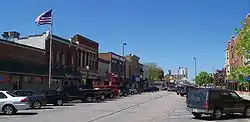 Downtown Shakopee | |
 Seal  | |
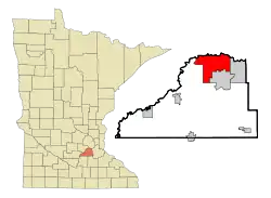 Location of the city of Shakopee within Scott County, Minnesota | |
| Coordinates: 44°47′50″N 93°31′35″W | |
| Country | United States |
| State | Minnesota |
| County | Scott |
| Incorporated | 1857 |
| Government | |
| • Mayor | William Mars |
| Area | |
| • City | 29.74 sq mi (77.04 km2) |
| • Land | 28.44 sq mi (73.67 km2) |
| • Water | 1.30 sq mi (3.37 km2) 4.47% |
| Elevation | 770 ft (234 m) |
| Population | |
| • City | 37,076 |
| • Estimate (2019)[3] | 41,570 |
| • Density | 1,461.57/sq mi (564.31/km2) |
| • Metro | 3,524,583 (US: 16th) |
| Time zone | UTC-6 (Central) |
| • Summer (DST) | UTC-5 (Central) |
| ZIP code | 55379 |
| Area code(s) | 952 |
| FIPS code | 27-59350 |
| GNIS feature ID | 0651898[4] |
| Website | www.ci. shakopee.mn.us |
The river bank's Shakopee Historic District contains burial mounds built by prehistoric cultures. In the 18th century, Chief Shakopee of the Mdewakanton Dakota established his village on the east end of this area near the water. Trading led to the city's establishment in the 19th century. Shakopee boomed as a commerce exchange site between river and rail at Murphy's Landing.
Once an isolated city in the Minnesota River Valley, by the 1960s the economy of Shakopee was tied to that of the expanding metropolitan area. Significant growth as a bedroom community occurred after U.S. Highway 169 was realigned in 1996 toward the new Bloomington Ferry Bridge.
The city is known for the Valleyfair amusement park and the Canterbury Park racetrack.
History

Burial mounds along the Minnesota River bluff, located within the present-day Veterans Memorial Park, have been dated between 500 and 2,000 years old.[6]
Following the Dakota migration from Mille Lacs Lake in the 17th century, several bands of Mdewakanton Dakota settled along the Minnesota River. They continued the mound building tradition. One of these bands was led in the 18th century by the first Chief Shakopee. The original Shakopee acquired his name when his wife, White Buffalo Woman, gave birth to sextuplet boys. Shakopee means "the six." The Ojibwa nation began pushing into Dakota territory and reportedly Shakopee's band skirmished in 1768 and 1775.[7] Shakopee died in 1827 at Fort Snelling.
The second man to be given the name Chief Shakopee was his adopted Ojibwa son, Eaglehead (b. 1794-1857), a twin son born to Ozaawindib, or "Yellowhead." Ozaawindib gave this son to the Dakota, as he had another to take the hereditary chief's role. Explorer Joseph Nicollet recorded that Eaglehead had been chosen in 1838 to lead the band and assume his father's name.[8]
By this time, Nicollet referred to the "Village of the Six," a permanent Dakota village south of the river, as acting as a boundary to the Ojibwa. However, historians have since situated it east of the present downtown.[7][8] He noted the village and locality was commonly called the "village of the prairie" (published as tinta ottonwe). The Shakopee band lived in summer bark lodges and winter tipis. They followed the changes of the season when they planted their cornfields.[7]
By the Treaty of Traverse des Sioux, the Sioux tribe ceded land in 1851 and many relocated to Chief Shakopee II's village. The latter people had moved south to what was later assigned to them as the current Shakopee-Mdewakanton Indian Reservation in nearby Prior Lake.[9] The band swelled to 400 people. Its leadership passed to Shakopee II's son Eatoka (b. 1811-1865). He was called Shakpedan (Little Shakopee/Little Six) at the death of his father.[10]
During the Dakota War of 1862, his warriors killed about 800 European-American settlers in an effort to regain their lands. Shakpedan was hanged at Fort Snelling in 1865 for his role in the rebellion.[10]
Descendants of the Mdewakanton Dakota placed 572 acres (2.31 km2) of Shakopee land into tribal land trust with the Department of Interior in 2003.[11]
Meanwhile, in 1851, Thomas A. Holmes established a trading post west of the Dakota and platted Shakopee Village in 1854, named after Chief Shakopee II.[10] The city quickly grew, incorporating in 1857. It surrendered its charter in 1861 due to conflicts in the Dakota War. As tensions lifted, the city incorporated again in 1870. The western end was left in township status and was renamed as Jackson Township, Minnesota in 1861, likely after President Andrew Jackson.[10]
In November 2017, it was discovered that then Shakopee superintendent Rod Thompson had used the district credit card to make 305 personal purchases, totaling over thirty thousand dollars. He was investigated by the FBI, and was charged with swindling and embezzlement. He resigned from his position as superintendent. He pled guilty to 19 counts of felony theft by swindling and embezzlement. He was sentenced to 24 months in prison, which he began serving in spring of 2019 in a minimum security prison in Duluth.[12] He used the money he embezzled to purchase first class flights, TV's, jewelry, and a pair of $220 red cowboy boots.[13]
Geography
According to the United States Census Bureau, the city has a total area of 29.32 square miles (75.94 km2); 28.01 square miles (72.55 km2) is land and 1.31 square miles (3.39 km2) is water.[14]
U.S. Highway 169 and County Highway 101 are two of the main routes in Shakopee. Highway 169 and nearby State Highway 13 connect Shakopee to the rest of the Minneapolis – Saint Paul region. County Highway 101 serves as a major east–west connector route of historic downtown Shakopee.
Demographics
| Historical population | |||
|---|---|---|---|
| Census | Pop. | %± | |
| 1860 | 1,138 | — | |
| 1870 | 1,349 | 18.5% | |
| 1880 | 2,011 | 49.1% | |
| 1890 | 1,757 | −12.6% | |
| 1900 | 2,047 | 16.5% | |
| 1910 | 2,302 | 12.5% | |
| 1920 | 1,988 | −13.6% | |
| 1930 | 2,023 | 1.8% | |
| 1940 | 2,418 | 19.5% | |
| 1950 | 3,185 | 31.7% | |
| 1960 | 5,201 | 63.3% | |
| 1970 | 6,876 | 32.2% | |
| 1980 | 9,941 | 44.6% | |
| 1990 | 11,739 | 18.1% | |
| 2000 | 20,568 | 75.2% | |
| 2010 | 37,076 | 80.3% | |
| 2019 (est.) | 41,570 | [3] | 12.1% |
| U.S. Decennial Census[15] 2018 Estimate[16] | |||
2010 census
As of the census[2] of 2010, there were 37,076 people, 12,772 households, and 9,275 families living in the city. The population density was 1,323.7 inhabitants per square mile (511.1/km2). There were 13,339 housing units at an average density of 476.2 per square mile (183.9/km2). The racial makeup of the city was 77.0% White, 4.3% African American, 1.2% Native American, 10.3% Asian, 4.5% from other races, and 2.7% from two or more races. Hispanic or Latino of any race were 7.8% of the population.
There were 12,772 households, of which 45.5% had children under the age of 18 living with them, 57.1% were married couples living together, 10.5% had a female householder with no husband present, 4.9% had a male householder with no wife present, and 27.4% were non-families. 20.4% of all households were made up of individuals, and 5.7% had someone living alone who was 65 years of age or older. The average household size was 2.83 and the average family size was 3.31.
The median age in the city was 32.2 years. 30.2% of residents were under the age of 18; 6.6% were between the ages of 18 and 24; 37.2% were from 25 to 44; 19.2% were from 45 to 64; and 6.8% were 65 years of age or older. The gender makeup of the city was 48.8% male and 51.2% female.
2000 census
At the 2000 census, there were 20,568 people, 7,540 households and 5,360 families living in the city. The population density was 761.7 per square mile (294.1/km2). There were 7,805 housing units at an average density of 289.0 per square mile (111.6/km2). The racial makeup of the city was 91.61% White, 1.33% African American, 0.94% Native American, 2.41% Asian, 0.04% Pacific Islander, 2.14% from other races, and 1.54% from two or more races. Hispanic or Latino of any race were 4.40% of the population.
There were 7,540 households, of which 38.9% had children under the age of 18 living with them, 58.2% were married couples living together, 8.6% had a female householder with no husband present, and 28.9% were non-families. 21.0% of all households were made up of individuals, and 5.7% had someone living alone who was 65 years of age or older. The average household size was 2.66 and the average family size was 3.12.
27.5% of the population were under the age of 18, 8.9% from 18 to 24, 38.8% from 25 to 44, 17.5% from 45 to 64, and 7.4% who were 65 years of age or older. The median age was 32 years. For every 100 females, there were 98.1 males. For every 100 females age 18 and over, there were 94.6 males.
The median household income was $59,137 and the median family income was $66,885 (these figures had risen to $72,523 and $83,235 respectively in a 2007 estimate). Males had a median income of $41,662 versus $32,244 for females. The per capita income for the city was $25,128. About 1.8% of families and 3.5% of the population were below the poverty line, including 3.6% of those under age 18 and 4.4% of those age 65 or over.
Education
Shakopee Public Schools (ISD 720) include five elementary schools, two middle schools and one senior high school, as well as a couple learning centers. The schools are:[17]
- Red Oak Elementary
- Sun Path Elementary
- Sweeney Elementary
- Eagle Creek Elementary
- Jackson Elementary
- Shakopee West Middle School
- Shakopee East Middle School
- Shakopee High School
- Tokata Learning Center
- Pearson Early Learning Center
- Central Family Center (closed for 2020-2021 School year for renovations)
District Leadership
- Mike Redmond- Superintendent
ISD 720 Board of Education:
- Kristi Peterson- Chair
- Judi Tomczik- Vice Chair
- Joe Aldrich- Treasurer
- Paul Christianson- Clerk
- Jeffrey Smith
- Ibrahim Mohamed
- Tim Brophy
Students in ninth through twelfth grade attend Shakopee High School. Students in sixth through eighth attend either Shakopee West or East Middle School and Students in K-5 attend one of the 5 elementary schools, in addition to this, there is also a learning center serving as a high school for troubled teens and, a Family Center for Early childhood education and preschool. Shakopee is also the location of the Shakopee Area Catholic Schools.
Living Hope Lutheran School is a Christian Pre-K-8 school of the Wisconsin Evangelical Lutheran Synod in Shakopee.[18]
The city of Shakopee also has a campus of the Globe University/Minnesota School of Business, a private career college offering programs in business, health sciences, legal sciences, multimedia and design, and information technology.
Politics
United States House of Representatives
- Angie Craig (D-MN-2)
State Legislature
- Eric Pratt (R-SD-55) in the Minnesota Senate
- Erik Mortensen (R-HD-55A) in the Minnesota House
Scott County Board of Commissioners
- Barb Weckman Brekke- P-5
- Mike Beard- P-1-4, P-6-8, P-12A, P- 12B
- Dave Beer- P-9-11, P-13
Shakopee City Council[19]
- Bill Mars - Mayor
- Matt Lehman- Vice Mayor
- Jay Whiting
- Jody Brennan
- Angelica Contreras
Places of worship
- Cross of Peace Lutheran Church
- Friendship Church
- Hosanna! Lutheran Church
- Mount Olive Evangelical Lutheran Church
- Resonate Community Church
- Slavic Baptist Church
- Saints Joachim & Anne
- ValleyView Baptist Church
- Living Hope Lutheran Church
- River Valley Church
- The Light of the World Church
- La Luz Del Mundo/The Light of the World
- New Hope Baptist Church
- St. John's Lutheran Church
Recreation
Located in Shakopee is a relatively new soccer complex that has a growing program. There are also several regional attractions (see below).
Notable people
- Jamal Abu-Shamala (1987-), a Jordanian-American basketball player for the Minnesota Golden Gophers, was born in Shakopee and went to the high school.
- Jack Bergman (1947-), United States Congressman and retired Marine Lieutenant General
- Anthony Bonsante (1970-), "The Bullet", is a professional boxer and competitor on the reality TV show The Contender.
- Scott Ferrozzo (1965-), a mixed martial artist who held a 4–2 record.
- Eleanor Gates (1874-1951), playwright.
- Amy Menke (1995-), professional ice hockey player
- Andrew Reiner, the executive editor of Game Informer Magazine, and guitarist in The Rapture Twins.
- Maurice Hubert Stans (1908-1998), United States Secretary of Commerce
- Christopher Straub (1979-), a contestant on Project Runway (season 6), lives in Shakopee.
- Samuel Suchta (2004-), oboist.
- Brad Tabke (1979-), Minnesota Representative, District 55A and former Mayor
Attractions
Shakopee is the location of several attractions that are well-recognized throughout the state and even nationally.
- Valleyfair is a family amusement park located just outside the Shakopee downtown on County Highway 101.
- The Landing is an 88-acre (360,000 m2) historic village located on the Minnesota River just outside downtown Shakopee. The Landing is a working representation of Minnesota life from the 1840s-1890s.
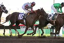
- Canterbury Park is a horse racetrack and card club located at the intersection of Canterbury Road and U.S. Highway 169.
- Minnesota Renaissance Festival attracts visitors from all over the world and is located south of Shakopee on U.S. Highway 169.
- Mystic Lake Casino is located nearby on the Shakopee-Mdewakanton Indian Reservation.
- Historic downtown Shakopee features numerous small town boutiques and restaurants, an old fashioned bakery, Turtle's 1890 Social Center, riverside concerts, and summertime bi-weekly classic car shows.
- Scott County Historical Society Museum and historic 1908 Stans House.[20]
In popular culture
- Shakopee was mentioned in the 2006 film Cars when the character Minny said she once went to Shakopee for "Crazy Days." The voice actress, Edie McClurg, ad-libbed the city's name into the script.[21] Shakopee does celebrate "Derby Days" named for the horse racing tradition of the city's history, and there may have been a predecessor to it called "Crazy Days." Most likely, however, this is a reference to sidewalk sales, which are common in the Midwest and often have names that include the term "Crazy Days".
- The Daily Show with Jon Stewart reported on the women's prison in Shakopee. The story was about the controversy of the fence-less prison and the arguments between citizens wanting or not wanting a fence.[22]
- Shakopee was the setting for a Saturday Night Live sketch in 2012 [23] with guest host Lindsay Lohan, and later in 2013[24] with Jennifer Lawrence, about the fictitious Shakopee Hip-Hop station 'B108FM'.
References
- "2019 U.S. Gazetteer Files". United States Census Bureau. Retrieved July 26, 2020.
- "U.S. Census website". United States Census Bureau. Retrieved November 13, 2012.
- "Population and Housing Unit Estimates". United States Census Bureau. May 24, 2020. Retrieved May 27, 2020.
- "US Board on Geographic Names". United States Geological Survey. October 25, 2007. Retrieved January 31, 2008.
- "2010 Census Redistricting Data (Public Law 94-171) Summary File" Check
|url=value (help). American FactFinder. United States Census Bureau. Retrieved April 27, 2011. - "SMSC To Conduct Prescribed Burn at Shakopee Memorial Park" (PDF). Shakopee Mdewakanton Sioux Community. April 22, 2004. Archived from the original (PDF) on October 29, 2008. Retrieved October 14, 2008.
- "Minnesota River History: People". Joseph R. Brown MN River Center. Retrieved October 16, 2008.
- Joseph Nicolas Nicollet (1976). Joseph N. Nicollet on the Plains and Prairies. Minnesota Historical Society Press. p. 45. ISBN 978-0-87351-290-9. Retrieved October 14, 2008.
- "Mdewakanton Band of the Dakota Nation (Part II)". Minneapolis Public Library. 2001. Archived from the original on September 25, 2008. Retrieved August 19, 2008.
- Warren Upham (1920). Minnesota Geographic Names. Minnesota Historical Society. p. 510. Retrieved October 14, 2008.
- Shannon Fiecke (December 2, 2008). "City ends fight over land-trust". Shakopee Valley News.
- mdebilzan@swpub.com, Maddie DeBilzan. "Thompson sentenced for swindling, embezzlement". SWNewsMedia.com. Retrieved June 11, 2020.
- "Former Shakopee schools superintendent charged with theft, embezzlement". Star Tribune. Retrieved June 11, 2020.
- "US Gazetteer files 2010". United States Census Bureau. Archived from the original on January 24, 2012. Retrieved November 13, 2012.
- United States Census Bureau. "Census of Population and Housing". Retrieved February 12, 2014.
- "Population Estimates". United States Census Bureau. Retrieved June 8, 2018.
- "Archived copy". Archived from the original on June 24, 2013. Retrieved June 4, 2012.CS1 maint: archived copy as title (link)
- "Living Hope Lutheran School".
- https://www.shakopeemn.gov/government/mayor-city-council
- http://scottcountyhistory.org/
- Pat Minelli (August 28, 2006). "The answer to Shock-o-pee reference in 'Cars'". Shakopee Valley News. Archived from the original on December 6, 2010.
- "The Daily Show with Trevor Noah". Comedy Central. Retrieved March 23, 2018.
- Fiecke, Shannon. "VIDEO: Shakopee makes SNL skit". SW News Media. SW News Media. Retrieved January 23, 2021.
- "'SNL' skit revisits Minnesota 'DJs'". Bring Me The News. Bring Me The News. Retrieved January 23, 2021.
External links
| Wikimedia Commons has media related to Shakopee, Minnesota. |
Municipalities and communities of Scott County, Minnesota, United States | ||
|---|---|---|
| Cities |
|  Map of Minnesota highlighting Scott County |
| Townships | ||
| Unincorporated communities | ||
| Ghost towns/Neighborhoods | ||
| Indian reservation | ||
| Footnotes | ‡This populated place also has portions in an adjacent county or counties | |
| ||

| Authority control |
|---|