Mojave National Preserve
Mojave National Preserve is a United States National Preserve located in the Mojave Desert of San Bernardino County, California, USA, between Interstate 15 and Interstate 40. The preserve was established October 31, 1994, with the passage of the California Desert Protection Act by the US Congress.[3] Previously, it was the East Mojave National Scenic Area, under the jurisdiction of the Bureau of Land Management.[4] At 1,542,776 acres (6,243 km2), it is the third largest unit of the National Park System in the contiguous United States.
| Mojave National Preserve | |
|---|---|
IUCN category V (protected landscape/seascape) | |
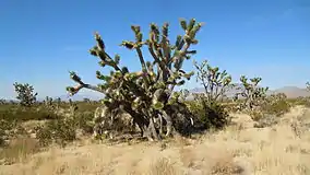 Joshua trees along Cima Road in the Mojave National Preserve | |
  | |
| Location | San Bernardino County, California, USA |
| Nearest city | Baker, California |
| Coordinates | 34°53′N 115°43′W |
| Area | 1,542,776 acres (6,243.39 km2)[1] |
| Created | October 31, 1994 |
| Visitors | 787,404 (in 2018)[2] |
| Governing body | National Park Service |
| Website | Mohave National Preserve |
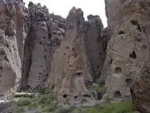
Natural features include the Kelso Dunes, the Marl Mountains and the Cima Dome, as well as volcanic formations such as Hole-in-the-Wall and the Cinder Cone Lava Beds. The preserve encloses Providence Mountains State Recreation Area and Mitchell Caverns Natural Preserve, which are both managed by the California Department of Parks and Recreation.
Impressive Joshua tree forests are found in parts of the preserve. The forest covering Cima Dome and the adjacent Shadow Valley is the largest and densest in the world.[5] In August of 2020 a wildfire destroyed 1.3 million Joshua Trees around Cima Dome. [6] The ghost town of Kelso is found in the preserve, with the defunct railroad depot serving as the Visitor Center. The preserve is commonly traversed by 4 wheel drive vehicles traveling on the historic Mojave Road.
Climate in the preserve varies greatly. Summer temperatures average 90 °F (32 °C), with highs exceeding 105 °F (41 °C). Elevations in the preserve range from 7,929 feet (2,417 m) at Clark Mountain to 880 feet (270 m) near Baker. Annual precipitation varies from 3.37 inches (86 mm) near Baker, to almost 9 inches (230 mm) in the mountains. At least 25% of precipitation comes from summer thunderstorms. Snow is often found in the mountains during the winter.
Mojave Wilderness
The California Desert Protection Act of 1994 (CDPA) designated a wilderness area within Mojave National Preserve of approximately 695,200 acres (281,300 ha). The National Park Service manages the wilderness in accordance with the Wilderness Act, the CDPA, and other laws that protect cultural and historic sites in the wilderness.[7]
Features
- Beale Mountains
- Cima, California
- Cima Dome & Volcanic Field National Natural Landmark
- Clark Mountain
- Devils Playground
- Granite Mountains
- Ivanpah, California
- Ivanpah Mountains
- Kelso, California
- Kelso Depot
- Kelso Dunes
- Kelso Mountains
- Kelso Wash
- Lanfair Valley
- Marl Mountains
- Mid Hills
- Mojave phone booth
- Mojave Road
- New York Mountains
- Old Dad Mountain
- Providence, California
- Providence Mountains
- Vanderbilt, California
- Vontrigger Hills
Climate
The following climate data is for a higher elevation area in the preserve. See also Climate of the Mojave Desert.
| Climate data for Mountain Pass, California. (Elevation 4,740 feet (1,440 m)) | |||||||||||||
|---|---|---|---|---|---|---|---|---|---|---|---|---|---|
| Month | Jan | Feb | Mar | Apr | May | Jun | Jul | Aug | Sep | Oct | Nov | Dec | Year |
| Record high °F (°C) | 71 (22) |
76 (24) |
81 (27) |
90 (32) |
104 (40) |
109 (43) |
110 (43) |
109 (43) |
102 (39) |
96 (36) |
89 (32) |
70 (21) |
110 (43) |
| Average high °F (°C) | 50.4 (10.2) |
53.7 (12.1) |
59.0 (15.0) |
66.4 (19.1) |
76.3 (24.6) |
87.0 (30.6) |
92.8 (33.8) |
89.9 (32.2) |
83.9 (28.8) |
72.4 (22.4) |
58.9 (14.9) |
51.1 (10.6) |
70.2 (21.2) |
| Average low °F (°C) | 29.5 (−1.4) |
32.4 (0.2) |
35.8 (2.1) |
41.0 (5.0) |
49.8 (9.9) |
59.2 (15.1) |
66.5 (19.2) |
64.5 (18.1) |
56.6 (13.7) |
46.3 (7.9) |
36.2 (2.3) |
30.2 (−1.0) |
45.7 (7.6) |
| Record low °F (°C) | 3 (−16) |
6 (−14) |
12 (−11) |
19 (−7) |
28 (−2) |
36 (2) |
42 (6) |
44 (7) |
33 (1) |
21 (−6) |
10 (−12) |
−2 (−19) |
−2 (−19) |
| Average precipitation inches (mm) | 0.92 (23) |
0.89 (23) |
0.89 (23) |
0.48 (12) |
0.27 (6.9) |
0.20 (5.1) |
1.04 (26) |
1.23 (31) |
0.59 (15) |
0.54 (14) |
0.68 (17) |
0.63 (16) |
8.36 (212) |
| Average snowfall inches (cm) | 2.7 (6.9) |
1.8 (4.6) |
1.4 (3.6) |
0.5 (1.3) |
0.2 (0.51) |
0 (0) |
0 (0) |
0 (0) |
0 (0) |
0.1 (0.25) |
1.1 (2.8) |
1.5 (3.8) |
9.3 (24) |
| Source: The Western Regional Climate Center[8] | |||||||||||||
See also
References
- "Listing of acreage as of December 31, 2011". Land Resource Division, National Park Service. Retrieved 2012-03-23.
- "NPS Annual Recreation Visits Report". National Park Service. Retrieved 2019-03-14.
- "California Desert Protection Act". Joshua Tree National Park. U.S. National Park Service. Retrieved 2015-08-02.
- "Mojave Wilderness". Wilderness.net. Retrieved 2009-05-06.
- "General Management Plan-Introduction" (PDF). National Park Service. p. 7. Retrieved 2009-05-06.
- https://www.nytimes.com/interactive/2020/12/09/climate/redwood-sequoia-tree-fire.html They're among the World's Oldest Living Things. The Climate Crisis is Killing Them. New York Times.
- "General Management Plan-Land Protection" (PDF). p. 3. Retrieved 2009-05-06.
- "Seasonal Temperature and Precipitation Information". Western Regional Climate Center. Retrieved March 29, 2013.
External links
| Wikimedia Commons has media related to Mojave National Preserve. |
| Wikivoyage has a travel guide for Mojave National Preserve. |
| Authority control |
|---|