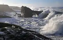
California Coastal National Monument
The California Coastal National Monument is located along the entire coastline of the U.S. state of California. This monument ensures the protection of all islets, reefs and rock outcroppings along the coast of California within 12 nautical miles (22 km) of shore along the entire 840-mile (1,350 km) long coastline. Conservative estimates are for at least 20,000 such outcroppings.[3] The monument was created by Bill Clinton via Presidential proclamation on January 11, 2000, with the authority in section two of the Antiquities Act of 1906. As of 2014, the monument has expanded to 2,272 acres (919 ha). The U.S. Bureau of Land Management, an agency of the U.S. Department of the Interior that manages the monument, has developed gateways in cooperation with other agencies along the California coast to introduce the monument to the public. These include the Trinidad Gateway, Point Arena Gateway, Fort Bragg-Mendocino Gateway, Pigeon Point Gateway, Piedras Blancas-San Simeon Gateway, and Palos Verdes Peninsula Gateway.[4] The California Coastal National Monument is one of the most-viewed national monuments in California, although people are usually unaware that they are viewing a national monument.[4]
| California Coastal National Monument | |
|---|---|
.jpg.webp) Stornetta Public Lands unit | |
| Area | 2,272 acres (919 ha)[1] |
| Created | January 11, 2000[2] |
| Governing body | Bureau of Land Management |
| Website | Official website |
.jpg.webp)
Expansion
The monument has seen two major expansions since its creation:
Point Arena-Stornetta Public Lands
On March 11, 2014, President Barack Obama used a presidential proclamation to add the Point Arena-Stornetta Public Lands to the monument.[5] The proclamation added 1,665 acres (674 ha) of onshore areas to the existing monument, comprising the estuary of the Garcia River.[6] The Point Arena-Stornetta Public Lands is located on the Mendocino County Coast, north of the small town of Point Arena.[7] Point Arena-Stornetta Public Lands will receive full federal protection and will be open to the public. The Point Arena-Stornetta Public Land is the only land-based segment of the national monument that visitors are allowed on.[8] Under federal protection, the public is allowed to use the land for bird watching, fishing, picnicking, nature photography, and wildlife observation.[9] Overnight camping and parking is prohibited. Along the coastal area there are numerous sinkholes and unsteady cliffs.[7]
California Coastal National Monument Expansion Act
.jpg.webp)
The California Coastal National Monument Expansion Act of 2017 [10] added five coastal sites: 440 acres (180 ha) at Lost Coast Headlands, 13 acres (5.3 ha) at Trinidad Head, 8 acres (3.2 ha) at Lighthouse Ranch in Humboldt County, 5,780 acres (2,340 ha) from the Cotoni-Coast Dairies in Santa Cruz County and 20 acres (8.1 ha) from Piedras Blancas in San Luis Obispo County. It also would include some small rocks and islands off the coast of Orange County.[11] In January 2017, President Obama used his executive power under the 1906 Antiquities Act to designate these sites as National Monuments.[12]
References
- "National Monument detail table as of April 2012" (PDF). Bureau of Land Management. Retrieved 2012-12-26.
- "California Coastal National Monument, Proclamation". Bureau of Land Management. Archived from the original on 2011-06-14. Retrieved 2010-06-28.
- Janofsky, Michael (December 13, 1999). "Amid Protests, Land-Protection Plan Goes to President". New York Times. Retrieved 2009-03-21.
- "California Coastal National Monument FY 2009 Manager's Report" (PDF). blm.gov. Archived from the original (PDF) on 2014-12-15. Retrieved 11 December 2014.
- Eilperin, Julie (March 11, 2014). "Obama uses executive authority to name Calif. preserve a national monument". Washington Post. Retrieved 19 April 2014.
- Eilperin, Julie (March 8, 2014). "Obama to designate monument in Point Arena-Stornetta Public Lands in California". Washington Post. Retrieved 19 April 2014.
- "Point Arena-Stornetta". U.S. Department of The Interior Bureau of Land Management. U.S. Department of The Interior Bureau of Land Management. Archived from the original on 9 December 2014. Retrieved 9 December 2014.
- Forgione, Mary. "California Coastal National Monument adds breathtaking new land". LA Times. LA Times. Retrieved 9 December 2014.
- Jeanne, Wirka (March 9, 2019). "Guidebook guru shares secrets of the North Coast". Santa Rosa Press Democrat. Retrieved 10 March 2019.
- "Presidential Proclamation -- Boundary Enlargement of the California Coastal National Monument". Obamawhitehouse.archives.ogov. 12 January 2017. Retrieved 1 November 2017.
- Wire, Sarah D. (September 9, 2016). "Should the California Coastal National Monument be expanded?". Los Angeles Times. Retrieved 10 September 2016.
- Boxall, Bettina (12 January 2017). "Obama adds six sites to California Coastal National Monument". Los Angeles Times. Retrieved 1 November 2017.
External links
| Wikimedia Commons has media related to California Coastal National Monument. |
- "California Coastal National Monument". Bureau of Land Management.
- "California Coastal National Monument map". Bureau of Land Management.
- Stornetta Public Lands
| Authority control |
|
|---|