Mole Gap Trail
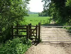
The Mole Gap Trail is a 10-kilometre (6.2 mi) official walking route alongside the River Mole, linking the Surrey towns of Dorking and Leatherhead.[1] The trail is marked on Ordnance Survey maps.[2] The trail runs through Norbury Park, the village of Westhumble and across Denbies Wine Estate.
| Mole Gap Trail | |
|---|---|
 | |
| Length | 10 km (6 mi) |
| Location | Surrey |
| Designation | Long Distance Footpath |
| Trailheads | Leatherhead station 51.2982°N 0.3332°W Dorking 51.2326°N 0.3307°W |
| Use | Hiking |
| Elevation | |
| Highest point | Denbies Vineyard 80 m OD |
| Lowest point | Town Bridge, Leatherhead 33 m OD |
Gallery
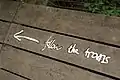 The trail is marked with metal direction signs, designed to look hand-written
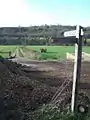 Footpath from Cowslip Farm to Norbury Park
See also
- Long-distance footpaths in the UK
- Thames Down Link
- North Downs Way
- London Loop
References
- "Mole Gap Trail" (PDF). Diamonds in the Landscape. Natural England. 5 October 2011. Archived from the original (PDF) on 30 September 2011.
- Kirby, James. "Mole Gap Trail". Long Distance Paths. Long Distance Walkers' Association. Retrieved 5 October 2011.
External links
| Wikimedia Commons has media related to Mole Gap Trail. |
This article is issued from Wikipedia. The text is licensed under Creative Commons - Attribution - Sharealike. Additional terms may apply for the media files.