Moneymore
Moneymore (from Irish: Muine Mór, meaning "large thicket or large hill")[1] is a village and townland in County Londonderry, Northern Ireland. It had a population of 1,369 in the 2001 Census. It is situated within Mid-Ulster District. It is an example of a plantation village in Mid-Ulster built by the Drapers' Company of London.
Moneymore
| |
|---|---|
 St John's Desertlynn Church of Ireland, in Moneymore | |
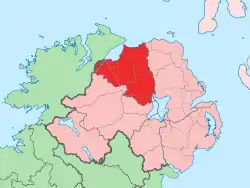
 Location within Northern Ireland | |
| Population | 1,369 (2001 Census) |
| Irish grid reference | H8583 |
| District | |
| County | |
| Country | Northern Ireland |
| Sovereign state | United Kingdom |
| Post town | MAGHERAFELT |
| Postcode district | BT |
| Dialling code | 028 |
| Police | Northern Ireland |
| Fire | Northern Ireland |
| Ambulance | Northern Ireland |
| UK Parliament | |
| NI Assembly | |
Geography
Moneymore lies in a glen. The Ballymully River flows through the southern part of the village. The river rises on a large hill, Slieve Gallion (one of the Sperrins), which has a radio tower on top. The village is about 35 miles (56.3 km) from the sea to the north.
History
There was an important battle fought near Moneymore called the battle of Móin Daire Lothair in the year 563 between the Northern Uí Néill and the Cruithin tribe which the Northern Uí Néill won. This battle is recorded in the Annals of Ulster and would have been a major event at the time. Much of Great Britain and Ireland would have descent from these two groups as there was notable mixing with Scotland over the years and the Uí Néill split to form the Southern Uí Néill in the Irish midlands around this time.
Originally built by the Worshipful Company of Drapers, the village was held in such esteem that they invested in a large scale reconstruction during 1817. During The Troubles, seven people were killed in or near Moneymore in violence related to the conflict, six of them by the Provisional IRA and one by the UDA.
People
- Henry Conwell (c. 1748 – 22 April 1842), Roman Catholic bishop in the United States
- Richard William Enraght, Anglican priest and religious controversialist. He was born in Moneymore on 23 February 1837, the son of the Reverend Matthew Enraght the Assistant Curate of the parish.[2]
- John Harris, surgeon, early settler of Australia, born Moneymore 1754
- Rodney Orpheus, Author and musician was born and raised in Moneymore.
Places of interest
The most notable building in the town is the 17th century Plantation house, Springhill, built and owned by the Conyngham, later Lenox-Conyngham family but since 1957 in the ownership of the National Trust.
Moneymore Model Village depicts life in rural Ulster at the time of the Plantation.
Transport
- Moneymore railway station opened on 10 November 1856 and shut on 2 May 1955.[3]
Sport
- Moneymore GAC is the local Gaelic Athletic Association club.
Schools
There are two primary schools in Moneymore: Moneymore Primary School (the state primary school) and St. Patrick's Primary School (a Roman Catholic primary school). Most children of secondary school age attend one of the schools in nearby Cookstown or Magherafelt.
Churches
- St. John's Church (Church of Ireland)
- Church of SS John & Trea (Roman Catholic)
- Moneymore First Presbyterian Church
- Moneymore Second Presbyterian Church
- Moneymore Congregational Church
- Moneymore Gospel Hall
2001 Census
Moneymore is classified as a village by the NI Statistics and Research Agency (NISRA) (i.e. with population between 1,000 and 2,250 people). On Census day (29 April 2001) there were 1,369 people living in Moneymore. Of these:
- 25.0% were aged under 16 years and 16.1% were aged 60 and over
- 45.29% of the population were male and 52.1% were female
- 47.8% were from a Catholic background and 51.0% were from a Protestant background;
- 3.1% of people aged 16–74 were unemployed.
For more details see: NI Neighbourhood Information Service
See also
External links
| Wikimedia Commons has media related to Moneymore. |
References
- Placenames Database of Ireland
- From the baptismal registers of St John's church Desertlyn
- "Moneymore station" (PDF). Railscot - Irish Railways. Retrieved 6 September 2007.