Sperrins
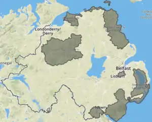
The Sperrins or Sperrin Mountains (from Irish Speirín 'little pinnacle'[4]) are a range of mountains in Northern Ireland and one of the largest upland areas in Northern Ireland. The range stretches from Strabane eastwards to Slieve Gallion in Desertmartin and north towards Limavady, in the counties of Tyrone and Londonderry. The region has a population of some 150,000 and is a designated Area of Outstanding Natural Beauty.
| The Sperrins | |
|---|---|
| Na Speiríní (Irish)[1] Sperrin Muntains (Ulster-Scots)[2] | |
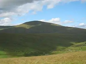 Sawel Mountain, the highest point of the Sperrins | |
| Highest point | |
| Peak | Sawel Mountain |
| Elevation | 678 m (2,224 ft) |
| Geography | |
| Sovereign state | United Kingdom |
| Constituent country | Northern Ireland |
| Counties | County Tyrone, County Londonderry |
| Range coordinates | 54°48′00″N 7°04′59″W |
| Geology | |
| Orogeny | Caledonian orogeny |
| Type of rock | Schist, quartzite,[3] granite, basalt, rhyolite |
Features
It has a distinctive glaciated landscape. The Glenshane Pass, part of the A6 Belfast to Derry road, is in the mountains and has notoriously bad weather in winter. Sawel Mountain is the highest peak in the Sperrins, and the seventh highest in Northern Ireland. Its summit rises to 678 m (2,224 ft). Another of the Sperrins, Carntogher (464 m), towers over the Glenshane Pass.[5]
Geologically, the Sperrins are formed mostly from Precambrian metamorphic rocks, with some younger Ordovician igneous rocks in the southern flank of the range. The Mountains are very sparsely populated and provide habitat for a diverse range of birds and mammals. Red fox, Sika Deer, Pine Marten and Red Squirrels are commonly found there alongside Peregrine Falcons, Buzzards and Sparrowhawks. Visiting Golden Eagles from the neighbouring reintroduced Donegal population have been sighted across the range from Strabane to Draperstown although no breeding population has yet been established. The Mountains also provide one of the last refuges of Red Grouse in Northern Ireland.
List
| Rank | Name | Irish name[6] | Height[7] | Prominence[7] |
|---|---|---|---|---|
| 1 | Sawel Mountain | Samhail Phite Méabha ("likeness of Méabh's vulva") | 678 m (2,224 ft) | 657 m (2,156 ft) |
| 2 | Mullaghclogha | Mullach Clocha ("summit of the stone") | 635 m (2,083 ft) | 207 m (679 ft) |
| 3 | Mullaghaneany | Mullach an Ionaidh ("summit of the wonder") | 627 m (2,057 ft) | 302 m (991 ft) |
| 4 | Meenard | Mín Ard ("high mountain pasture") | 620 m (2,030 ft) | 85 m (279 ft) |
| 5 | Dart Mountain | An Dairt ("the lump") | 619 m (2,031 ft) | 89 m (292 ft) |
| 6 | Mullaghasturrakeen | Mullach an Starraicín ("summit of the steeple") | 581 m (1,906 ft) | 46 m (151 ft) |
| 7 | Mullaghclogher | Mullach Clochair ("summit of the stony patch") | 572 m (1,877 ft) | 127 m (417 ft) |
| 8 | Oughtmore | Ucht Mór ("big mountain breast") | 569 m (1,867 ft) | 104 m (341 ft) |
| 9 | Spelhoagh | Speilg Chuach ("cuckoo rock") | 568 m (1,864 ft) | 20 m (66 ft) |
| 10 | Mullaghdoo | Mullach Dubh ("black summit") | 568 m (1,864 ft) | 20 m (66 ft) |
| 11 | Carnanelly | Carnán Aichle ("little cairn of the lookout") | 562 m (1,844 ft) | 307 m (1,007 ft) |
| 12 | Mullaghmore | Mullach Mór ("big summit") | 550 m (1,800 ft) | 235 m (771 ft) |
| 13 | Mullaghcarn | Mullach Cairn ("summit of the cairn") | 542 m (1,778 ft) | 377 m (1,237 ft) |
| 14 | White Mountain | Sliabh Bán ("white mountain") | 537 m (1,762 ft) | 42 m (138 ft) |
| 15 | Slieve Gallion | Sliabh gCallann ("mountain of the heights") | 528 m (1,732 ft) | 333 m (1,093 ft) |
| 16 | Crockbrack | Cnoc Breac ("speckled hill") | 526 m (1,726 ft) | 151 m (495 ft) |
| 17 | Mullaghcarbatagh | Mullach Carbadach ("boulder-strewn summit") | 517 m (1,696 ft) | 32 m (105 ft) |
See also
- List of mountains in Ireland

References
- Hoare, Natalie (July 2009) UK Landscapes, The Sperrins, Geographical Magazine
- "Ulstèr Merikay Fowk Pairk, Youngstèrs Wisin". National Museums Northern Ireland. Archived from the original on 11 October 2013. Retrieved 19 July 2017.
- The Rock Cycle, Schist, Co Tyrone, The Geological Society
- Ulster Place Names - Magherafelt (C. Dunbar)
- "Glenshane Slopes Landscape". Environment and Heritage Service. Archived from the original on 31 July 2012. Retrieved 26 June 2008.
- Paul Tempan (February 2012). "Irish Hill and Mountain Names" (PDF). MountainViews.
- and Arderin Begs. MountainViews.
External links
- Landscapes Unlocked - Aerial footage from the BBC Sky High series explaining the physical, social and economic geography of Northern Ireland.
Mountains and hills of Ulster | ||
|---|---|---|
| Antrim Hills |  | |
| Antrim Plateau | ||
| Belfast Hills | ||
| Croaghgorms | ||
| Derryveagh | ||
| Inishowen | ||
| Mournes | ||
| Sperrins | ||
| Southwest Donegal | ||
| Others | ||
| ||
Areas marked † are proposed | ||