Magherafelt
Magherafelt (from Irish: Machaire Fíolta, meaning "plain of Fíolta", IPA:[ˈmˠaxəɾʲəˈfʲiːlt̪ˠə])[2] is a small town and civil parish in County Londonderry, Northern Ireland. It had a population of 8,805 at the 2011 Census.[3] It is the biggest town in the south of the county and is the social, economic and political hub of the area. It is part of Mid-Ulster District.
| Magherafelt | |
|---|---|
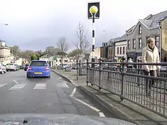 Magherafelt, near the town centre. | |
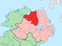
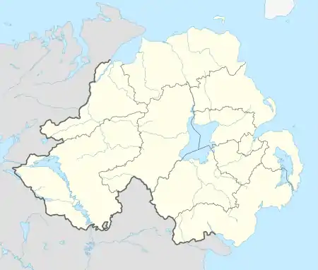 Location within Northern Ireland | |
| Population | 8,805 (2011 Census) |
| • Belfast | 35 mi (56 km) |
| District | |
| County | |
| Country | Northern Ireland |
| Sovereign state | United Kingdom |
| Post town | MAGHERAFELT |
| Postcode district | BT45 |
| Dialling code | 028 |
| Police | Northern Ireland |
| Fire | Northern Ireland |
| Ambulance | Northern Ireland |
| UK Parliament | |
| NI Assembly | |
History
Magherafelt has been documented as a town since 1425. An earlier name for the area was Teach Fíolta - ‘Fíolta’s (monastic) house’. This would suggest that there was a monastic settlement here under the leadership of Fíolta.[4] The site of the medieval parish church may be marked by the ruins of a later church and graveyard at the bottom of Broad Street.[5]
The Salters Company of London[6] was granted the surrounding lands in South Londonderry in the seventeenth century as part of the Plantation of Ulster. Subsequently, the town began to take on its current shape with a central diamond forming the heart of the town.[7]
During The Troubles in the late 20th century, 11 people were killed in or near Magherafelt in connection with the conflict.
Governance
The town had its own Magherafelt District Council. On 1 April 2015, it was merged with Cookstown District Council and Dungannon and South Tyrone Borough Council under local government reorganisation in Northern Ireland becoming Mid-Ulster District Council. The Mid Ulster District Council has 40 councillors of which five are elected by the electors of Magherafelt. In the 2019 Mid Ulster District Council election, the five elected councillors included two members of Sinn Féin, one member of the SDLP and two members of the Democratic Unionist Party.
It is located within the Mid Ulster (Assembly constituency) in the Northern Ireland Assembly and the Mid Ulster (UK Parliament constituency). The current MP is Francie Molloy of Sinn Féin.
Notable buildings
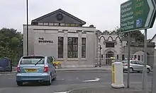
At the foot of Broad Street is located The Bridewell. This building previously housed the town's court-house and gaol (jail). The name Bridewell is a common name in Britain and Ireland for a prison (see Bridewell Palace). It has since been refurbished and now houses the town's library and tourist centre.[8]
Churches
- Catholic Church of Our Lady of the Assumption (1882)[9]
- St. Swithin's Church of Ireland (1858) [10]
- First Presbyterian Church (1738)[11]
- Calvary Free Presbyterian Church (1978)[12]
- Magherafelt Baptist Church (2007)[13]
Transport
Road
Magherafelt lies on the A31 route which connects the south west of the province (Tyrone, Fermanagh) to the north east (Coleraine, Ballymena etc). Traffic from north and south used to pass through the town centre frequently leading to considerable congestion. In the 1970s a bypass was proposed route which was eventually funded in 2013 and completed in 2016. The road is a single-carriageway around the eastern edge of the town connecting Moneymore Road and Castledawson Road. The old road through the town became the B40 when the road opened.[14]
Rail
Magherafelt railway station opened on 10 November 1856, shut for passenger traffic on 28 August 1950 and shut altogether on 1 October 1959.[15]
Schools
Primary Schools:
- Holy Family Primary School
- Kilronan Special School
- Gaelscoil an tSeanchaí
- Naíscoil an tSeanchaí
- Magherafelt Controlled Primary School
- Magherafelt Primary
- Integrated Primary School
Secondary Schools:
- St. Mary's Grammar School
- Saint Pius X College
- Rainey Endowed School
- Sperrin Integrated College
- Magherafelt High School
Sport
Magherafelt has several sporting teams, including Magherafelt Reds, O'Donovan Rossa Magherafelt GAC, the Rainey Old Boys Rugby Club and Magherafelt Sky Blues F.C.. There is also the Mid Ulster Athletic Club,Spires CC Cycling Club. the Mid Ulster Swimming Club and the Magherafelt District Motorclub.[16]
Demography
At the 2011 census, there were 8,805 people living in Magherafelt.[3] This represented an increase of 5.2% on the Census 2001 population of 8,372.[17] Of these:
- 21.75% were aged under 16 years and 12.44% were aged 65 and over
- 48.65% of the population were male and 51.35% were female
- 59.73% were from a Catholic background and 35.67% were from a Protestant or other Christian background
- 5.65% of people aged 16–74 were unemployed.
People
- Jonathan Anderson (born 1984) – fashion designer
- Joseph Burns (1906- ) – an Ulster Unionist member of the Parliament of Northern Ireland from 1960 – 1973
- Paul Charles (born 1949) – novelist, music promoter and talent agent
- Peter Doherty (1913-1990) – former footballer and manager of Northern Ireland[18]
- Barry Gillis (born 1980) – current Derry Gaelic footballer
- Monsignor Laurence Higgins (1928-2016) – former Vicar General of the Diocese of St. Petersburg and founder of St. Lawrence Catholic Parish in Tampa, Florida
- Harry Gregg (1932-2020) – former Manchester United and Northern Ireland goalkeeper
- Robert Hagan (1794- ) - naval officer and abolitionist
- Aaron Hughes (born 1979) – current professional Association Footballer
- Willie McCrea (born 1948) – politician and a member of the Democratic Unionist Party
- Terry McFlynn (born 1981) – a current football player for Sydney FC and former Northern Ireland Under 21 player
- Mickey Niblock – former Derry Gaelic footballer
- Laura Pyper (born 1980) – actress (Hex, Reign of Fire and Headrush)
- Dean Shiels (born 1985) – professional association football player
- Kenny Shiels (born 1956) – former manager of Derry City
- Sir James Starritt, KCVO (1914-2000) – Deputy Commissioner of Police of the Metropolis from 1972–75
See also
References
- The Online Scots Dictionary Retrieved 11 June 2012.
- Placenames Database of Ireland
- "Census 2011 Population Statistics for Magherafelt Settlement". Northern Ireland Statistics and Research Agency (NISRA). Retrieved 8 August 2019.
- "A short history of the parish of Magherafelt". Retrieved 6 September 2019.
- "Place Names NI". Retrieved 6 September 2019.
- "The Salters Company". Retrieved 6 September 2019.
- "A short history of the parish of Magherafelt". Retrieved 6 September 2019.
- "Your Pace and Mine - Bridewell's History". Retrieved 6 September 2019.
- "Church of Our Lady of the Assumption". Church of Our Lady of the Assumption. Retrieved 21 October 2020.
- "St. Swithin's Church". St. Swithin's Church. Retrieved 21 October 2020.
- "First Presbyterian Church". First Presbyterian Church. Retrieved 21 October 2020.
- "Calvary Free Presbyterian Church". Calvary Free Presbyterian Church. Retrieved 21 October 2020.
- "History". Magherafelt Baptist. Retrieved 21 October 2020.
- "A31 Magherafelt Bypass". Retrieved 6 September 2019.
- "Magherafelt station" (PDF). Railscot – Irish Railways. Retrieved 3 November 2007.
- http://www.magherafeltmotorclub.co.uk/
- "Census 2001 Usually Resident Population: KS01 (Settlements) - Table view". Northern Ireland Statistics and Research Agency (NISRA). p. 5. Retrieved 8 August 2019.
- Peter Doherty Archived 13 January 2013 at Archive.today
| Wikimedia Commons has media related to Magherafelt. |
External links
List of towns by population | ||
| Large |  | |
| Medium | ||
| Small | ||
Italics denote settlements that are classed as towns but also have city status
| ||
| Authority control |
|---|