Montezuma, California
Montezuma is a former hamlet and township in Solano County, California, located in the California Delta region of the state; the township, which embraced the hamlet, and several other places, such as Bird's Landing—which still exists—included portions of the Montezuma Hills. The name Montezuma was used in multiple places within Solano County by Mormans settlement attempts during 1847–50.[1]
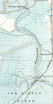

The hamlet was also a stop on the Oakland, Antioch and Eastern Railway (later absorbed into the Sacramento Northern Railway), an electrified interurban passenger rail line that ran, with the help of a ferry across Suisun Bay, from Oakland, through Contra Costa County, across the bay, and into Solano County, making stops at Chipps and Dutton, before passing through Montezuma on its way to Rio Vista, California. The railway stop was located approximately a mile and a half northwest of present-day Collinsville, just after the rail line swung due north, from its north-easterly trajectory from the ferry landing at Chipps Island, at the Suisun Bay shoreline.
Montezuma is a California Historical Landmark.[2]
California Historical Landmark number 122 reads:
- NO. 122 MONTEZUMA - First record of Montezuma was June 1850 when partners Solomon Miller and Peter K. Aurand, proprietors of the 'Montezuma Tent,' were attacked and Aurand killed by a group of Mexicans during the foreign miners tax excitement of that period. Due to the lack of water, little mining occurred here until 1852 when a ditch and flume were completed bringing water for placer mining. Two types of mining were carried on, placer operations on the flats and tunnels extending under Table Mountain. The gravel produced 3-1/2 C. per pan in the mid 50s. The yield was from $5 to $10 per day. One placer nugget found in 1853 weighed 18 lbs. 8 oz. By late 1852 the population was about 800. At its zenith Montezuma City had four saloons, two hotels, Adams Express Co., post office, church, some homes, and many tents and cabins. The town was nearly destroyed by an incendiary fire which started in Clarks Hotel on June 29, 1866. [3]
References
- Gudde, Erwin G. (1998). California place names : the origin and etymology of current geographical names (4th ed., rev. and enl. ed.). Berkeley: University of California Press. p. 246. ISBN 0520213165.
- California Parks, California Historical Landmark
- californiahistoricallandmarks.com Landmarks chl-122
- "1. Official Map of the County of Solano - 1915". Solano County Board of Supervisors. Retrieved September 16, 2011.
- "2. Sacramento Northern Railway System Map - 1939". Sacramento Northern Railway. Archived from the original on April 2, 2012. Retrieved September 15, 2011.
Municipalities and communities of Solano County, California, United States | ||
|---|---|---|
| Cities |  Solano County map | |
| CDPs | ||
| Unincorporated communities | ||
| Ghost towns |
| |
| ||
