Mount Merapi
Mount Merapi, Gunung Merapi (literally Fire Mountain in Indonesian and Javanese), is an active stratovolcano located on the border between Central Java and Special Region of Yogyakarta provinces, Indonesia. It is the most active volcano in Indonesia and has erupted regularly since 1548. It is located approximately 28 kilometres (17 mi) north of Yogyakarta city which has a population of 2.4 million, and thousands of people live on the flanks of the volcano, with villages as high as 1,700 metres (5,577 ft) above sea level.
| Mount Merapi | |
|---|---|
| Gunung Merapi | |
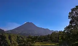 Mount Merapi, as of 2018 | |
| Highest point | |
| Elevation | 2,910 m (9,550 ft) [1] |
| Prominence | 1,356 m (4,449 ft) [2] |
| Listing | Ribu |
| Coordinates | 7°32′26.99″S 110°26′41.34″E |
| Naming | |
| English translation | Mountain of Fire |
| Language of name | Indonesian |
| Geography | |
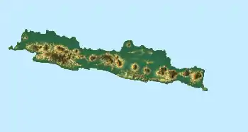 Mount Merapi Location in Java | |
| Geology | |
| Age of rock | 400,000 years |
| Mountain type | Active Stratovolcano |
| Last eruption | Jan 27, 2021 |
_-_Mieling%252C_C.W._-_Mount_Merapi_(Gunung_Merapi)_-_Colour_lithography_-_1853-1854.tif.jpg.webp)
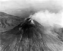
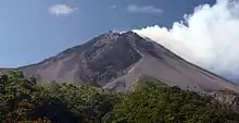
Smoke can often be seen emerging from the mountaintop, and several eruptions have caused fatalities. Pyroclastic flow from a large explosion killed 27 people on 22 November 1994, mostly in the town of Muntilan, west of the volcano.[3] Another large eruption occurred in 2006, shortly before the Yogyakarta earthquake. In light of the hazards that Merapi poses to populated areas, it has been designated as one of the Decade Volcanoes.
On 20 October 2010, the Indonesian government raised the alert for Mount Merapi to its highest level and warned villagers in threatened areas to move to safer ground. People living within the range of a 20 km (12 mi) zone were told to evacuate. Officials said about 500 volcanic earthquakes had been recorded on the mountain over the weekend of 23–24 October, and that the magma had risen to about 1 kilometre (3,300 ft) below the surface due to the seismic activity.[4] On the afternoon of 25 October 2010, Mount Merapi erupted lava from its southern and southeastern slopes.[5]
The mountain was still erupting on 30 November 2010, but due to lowered eruptive activity on 3 December 2010, the official alert status was reduced to level 3.[6] The volcano is now 2,930 metres (9,613 ft) high,[2] 38 metres (125 ft) lower than before the 2010 eruptions.
After a large eruption in 2010, the characteristic shape of Mount Merapi was changed. On 18 November 2013, Mount Merapi erupted smoke up to 2,000 metres (6,562 ft) high, one of its first major phreatic eruptions after the 2010 eruption. Researchers said that this eruption occurred due to the combined effect of hot volcanic gases and abundant rainfall.[7] The most recent eruptions so far were on 3 March 2020,[8][9] 27 March 2020,[10] and 7 January 2021.[11]
Etymology
The name Merapi could be loosely translated as the Mountain of Fire. The etymology of the name came from Meru-Api; from the ancient classical language of India Sanskrit and Javanese combined words; Meru means "mountain", refers to mountain of Gods in Hinduism, and api means "fire".
History
Geological history
Merapi is the youngest in a group of volcanoes in southern Java. It is situated at a subduction zone, where the Indo-Australian Plate is subducting under the Sunda Plate. It is one of at least 129 active volcanoes in Indonesia, part of the volcano is located in the Southeastern part of the Pacific Ring of Fire–a section of fault lines stretching from the Western Hemisphere through Japan and South East Asia.[12] Stratigraphic analysis reveals that eruptions in the Merapi area began about 400,000 years ago, and from then until about 10,000 years ago, eruptions were typically effusive, and the out flowing lava emitted was basaltic. Since then, eruptions have become more explosive, with viscous andesitic lavas often generating lava domes. Dome collapse has often generated pyroclastic flows, and larger explosions, which have resulted in eruption columns, have also generated pyroclastic flows through column collapse.
Typically, small eruptions occur every two to three years, and larger ones every 10–15 years or so. Notable eruptions, often causing many deaths, have occurred in 1006, 1786, 1822, 1872, and 1930. Thirteen villages were destroyed in the latter one, and 1,400 people were killed by pyroclastic flows.
The very large eruption in 1006 is claimed to have covered all of central Java with ash. The volcanic devastation is claimed to have led to the collapse of the Hindu Kingdom of Mataram; however, the evidence from that era is insufficient for this to be substantiated.
2006 eruption
In April 2006, increased seismicity at more regular intervals and a detected bulge in the volcano's cone indicated that fresh eruptions were imminent. Authorities put the volcano's neighboring villages on high alert and local residents prepared for a likely evacuation. On 19 April smoke from the crater reached a height of 400 metres (1,300 ft), compared to 75 metres (246 ft) the previous day. On 23 April, after nine surface tremors and some 156 multifaced quakes signalled movements of magma, some 600 elderly and infant residents of the slopes were evacuated.[13]
By early May, active lava flows had begun. On 11 May, with lava flow beginning to be constant, some 17,000 people were ordered to be evacuated from the area[14] and on 13 May, Indonesian authorities raised the alert status to the highest level, ordering the immediate evacuation of all residents on the mountain.[15] Many villagers defied the dangers posed by the volcano and returned to their villages, fearing that their livestock and crops would be vulnerable to theft.[12] Activity calmed by the middle of May.[16]
On 27 May, a 6.3 magnitude earthquake struck roughly 50 km (31 mi) southwest of Merapi,[17] killing at least 5,000 and leaving at least 200,000 people homeless in the Yogyakarta region, heightening fears that Merapi would "blow".[18] The quake did not appear to be a long-period oscillation, a seismic disturbance class that is increasingly associated with major volcanic eruptions. A further 11,000 villagers were evacuated on 6 June as lava and superheated clouds of gas poured repeatedly down its upper slopes towards Kaliadem,[19] a location that was located southeast of Mt. Merapi.[20] The pyroclastic flows are known locally as "wedhus gembel" (Javanese for "shaggy goat"). There were two fatalities as the result of the eruption.
2010 eruption
In late October 2010 the Center for Volcanology and Geological Hazard Mitigation, Geological Agency (CVGHM), (Indonesian language—Pusat Vulkanologi & Mitigasi Bencana Geologi, Badan Geologi-PVMBG), reported that a pattern of increasing seismicity from Merapi had begun to emerge in early September.
Observers at Babadan 7 kilometres (4.3 mi) west and Kaliurang 8 kilometres (5.0 mi) south of the mountain reported hearing an avalanche on 12 September 2010. On 13 September 2010 white plumes were observed rising 800 metres (2,600 ft) above the crater. Lava dome inflation, detected since March, increased from background levels of 0.1 millimetres (0.0039 in) to 0.3 millimetres (0.012 in) per day to a rate of 11 millimetres (0.43 in) per day on 16 September. On 19 September 2010 earthquakes continued to be numerous, and the next day CVGHM raised the Alert Level to 2 (on a scale of 1–4).[21] Lava from Mount Merapi in Central Java began flowing down the Gendol River on 23–24 October signalling the likelihood of an imminent eruption.[22]
On 25 October 2010, the Indonesian government raised the alert for Mount Merapi to its highest level (4) and warned villagers in threatened areas to move to safer ground. People living within a 10 kilometres (6.2 mi) zone were told to evacuate. The evacuation orders affected at least 19,000 people; however, the number that complied at the time remained unclear to authorities.[23] Officials said about 500 volcanic earthquakes had been recorded on the mountain over the weekend of 23–24 October, and that the magma had risen to about 1 kilometre (3,300 ft) below the surface due to the seismic activity[24]
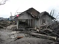
After a period of multiple eruptions considered to exceed the intensity and duration of those in 1872[25] on 10 November 2010 the intensity and frequency of eruptions was noticed to subside.[26] By this time, 153 people had been reported to have been killed and 320,000 were displaced.[27] Later the eruptive activities again increased requiring a continuation of the Level 4 alert and continued provision of exclusion zones around the volcano.[28][29] By 18 November the death toll had increased to 275.[30] The toll had risen to 324 by 24 November and Syamsul Maarif, head of the National Disaster Mitigation Agency (BNPB) explained that the death toll had risen after a number of victims succumbed to severe burns and more bodies were found on the volcano's slopes.[31]
In the aftermath of the more intensive eruptive activities in late November, Yogyakarta's Disaster Management Agency reported that there were about 500 reported cases of eruption survivors in Sleman district suffering from minor to severe psychological problems, and about 300 cases in Magelang.[31] By 3 December the death toll had risen to 353.[32]
On Friday, 3 December 2010, the head of the National Disaster Management Agency (BNPB), Dr. Syamsul Maarif, M. Si, accompanied by the head of the Centre for Volcanology and Geological Hazard Mitigation CVGHM (PVMBG), Dr. Surono made a joint press release at the BNPB Command Post in Yogyakarta. As of 3 December 2010, at 09.00 am, the CVGHM (PVMBG) lowered the status of Mount Merapi to the level of Caution Alert (Level III). They clarified that with this alert level the potential of hot ash clouds and projected incandescent material remained. The Geological Agency provided several recommendations including that there would be no community activities in the disaster prone areas and proclaimed an ongoing exclusion zone of 2.5 kilometres (1.6 mi) radius.[33]
2018 eruption
A phreatic eruption began on the morning of 11 May 2018, prompting the evacuation of areas within a 5-kilometre (3.1 mi) radius of the volcano. Adisutjipto International Airport in Yogyakarta was closed due to the eruption's ash plume. This eruption initiated a new phase of dome growth. It led to new evacuations at Merapi in November 2020. The danger of pyroclastic flows was increasing and expanding.[34][35][36][37]
Monitoring
.svg.png.webp)
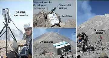
Mount Merapi is the site of a very active volcano monitoring program. Seismic monitoring began in 1924, with some of the volcano monitoring stations lasting until the present. The Babadan (northwest location), Selo (in the saddle between Merbabu and Merapi), and Plawangan monitoring stations have been updated with equipment over the decades since establishment. During the 1950s and early 1960s some of the stations were starved of equipment and funds, but after the 1970s considerable improvement occurred with the supply of new equipment. Some of the pre-1930 observation posts were destroyed by the 1930 eruption, and newer posts were re-located. Similarly after the 1994 eruption, the Plawangan post and equipment were moved into Kaliurang as a response to the threat of danger to the volcanological personnel at the higher point. This volcano is monitored by the Deep Earth Carbon Degassing Project.
The eruption of 1930 was found to have been preceded by a large earthquake swarm. The network of 8 seismographs currently around the volcano allow volcanologists to accurately pinpoint the hypocentres of tremors and quakes.
A zone in which no quakes originate is found about 1.5 km below the summit, and is thought to be the location of the magma reservoir which feeds the eruptions.
Other measurements taken on the volcano include magnetic measurements and tilt measurements. Small changes in the local magnetic field have been found to coincide with eruptions, and tilt measurements reveal the inflation of the volcano caused when the magma chambers beneath it is filling up.
Lahars (a type of mudflow of pyroclastic material and water) are an important hazard on the mountain, and are caused by rain remobilizing pyroclastic flow deposits. Lahars can be detected seismically, as they cause a high-frequency seismic signal. Observations have found that about 50 mm of rain per hour is the threshold above which lahars are often generated.
Sabo Dam
There are about 90 units (30 percent) from the total 258 units of sand barriers (sabo) were damaged. The cost for recovery is about Rp.1 trillion ($116 million).[40]
Sterile zone
Following the 2010 eruption, three Indonesian government departments declared a prohibited zone which nobody can permanently stay and no infrastructure is allowed in 9 villages (dusun): Palemsari, Pangukrejo, Kaliadem, Jambu, Kopeng, Petung, Kalitengah Lor, Kalitengah Kidul and Srunen, all in Cangkringan district.[41]
National park
In 2004, an area of 6,410 hectares around Mount Merapi was established as a national park. The decision of the Ministry of Forestry to declare the park has been subsequently challenged in court by The Indonesian Forum for Environment, on grounds of lack of consultation with local residents.[42] During the 2006 eruption of the volcano it was reported that many residents were reluctant to leave because they feared their residences would be confiscated for expansion of the national park, meaning they wouldn't have a house.[43]
Museum
- Merapi Museum Center, Kaliurang Street Kilometer 25.7, Pakem subdistrict, Sleman, Yogyakarta. A replica of Merapi's Post 2010 Eruption has been created and Indonesian student visits to the museum has increased 30 percent since the latest eruption.[44]
Mythology
Merapi is very important to Javanese, especially those living around its crater. As such, there are many myths and beliefs attached to Merapi.
Creation
Although most nearby villages have their own myths about the creation of Mount Merapi, they have numerous commonalities. It is believed that when the gods had just created the Earth, Java was unbalanced because of the placement of Mount Jamurdipo on the west end of the island. In order to assure balance, the gods (generally represented by Batara Guru) ordered the mountain to be moved to the centre of Java. However, two armourers, Empu Rama and Empu Permadi, were already forging a sacred keris at the site where Mount Jamurdipo was to be moved. The gods warned them that they would be moving a mountain there, and that they should leave; Empu Rama and Empu Permadi ignored that warning. In anger, the gods buried Empu Rama and Empu Permadi under Mount Jamurdipo; their spirits later became the rulers of all mystical beings in the area. In memory of them, Mount Jamurdipo was later renamed Mount Merapi, which means "fire of Rama and Permadi."[45]
Spirit Kraton of Merapi
The Javanese believe that the Earth is not only populated by human beings, but also by spirits (makhluk halus). Villages near Merapi believe that one of the palaces (in Javanese kraton) used by the rulers of the spirit kingdom lies inside Merapi, ruled by Empu Rama and Empu Permadi. This palace is said to be a spiritual counterpart to the Yogyakarta Sultanate, complete with roads, soldiers, princes, vehicles, and domesticated animals. Besides the rulers, the palace is said to also be populated by the spirits of ancestors who died as righteous people. The spirits of these ancestors are said to live in the palace as royal servants (abdi dalem), occasionally visiting their descendants in dreams to give prophecies or warnings. "[46]
Spirits of Merapi
To keep the volcano quiet and to appease the spirits of the mountain, the Javanese regularly bring offerings on the anniversary of the sultan of Yogyakarta's coronation.[47] For Yogyakarta Sultanate, Merapi holds a significant cosmological symbolism, because it forms a sacred north-south axis line between Merapi peak and Southern Ocean (Indian Ocean). The sacred axis is signified by Merapi peak in the north, the Tugu Yogyakarta monument near Yogyakarta main train station, the axis runs along Malioboro street to Northern Alun-alun (square) across Keraton Yogyakarta (sultan palace), Southern Alun-alun, all the way to Bantul and finally reach Samas and Parangkusumo beach on the estuary of Opak river and Southern Ocean.[48] This sacred axis connected the hyangs or spirits of mountain revered since ancient times—often identified as "Mbah Petruk" by Javanese people—The Sultan of Yogyakarta as the leader of the Javanese kingdom, and Nyi Roro Kidul as the queen of the Southern Ocean, the female ocean deity revered by Javanese people and also mythical consort of Javanese kings.[49]
See also
Further reading
- François Beauducel & François-Henri Cornet-Institut de Physique du Globe de Paris, Dpt Seismology, Edi Suhanto, Made Agung-Volcanological Survey of Indonesia, Constraint from displacement data on magma flux at Merapi volcano, Java.[50]
- François Beauducel and François-Henri Cornet-Département de Sismologie, Institut de Physique du Globe de Paris, France. Edi Suhanto, Made Agung-Volcanological Survey of Indonesia, Bandung, Indonesia. T. Duquesnoy and M. Kasser-Institut Géographique National, St-Mandé, France. Java, Indonesia, Journal of Geophysical research, (Vol unknown) 2000, Constraints on magma flux from displacements data at Merapi volcano[51]
- Camus G, Gourgaud A, Mossand-Berthommier P-C, Vincent P-M, 2000. Merapi (central Java, Indonesia): an outline of the structural and magmatological evolution, with a special emphasis to the major pyroclastic events. J Volc Geotherm Res, 100: 139–163
- Charbonnier S J, Gertisser R, 2008. Field observations and surface characteristics of pristine block-and-ash flow deposits from the 2006 eruption of Merapi volcano, Java, Indonesia. J Volc Geotherm Res, 177: 971–982
- Gertisser R, Keller J, 2003. Temporal variations in magma composition at Merapi volcano (Central Java, Indonesia): magmatic cycles during the past 2000 years of explosive activity. J Volc Geotherm Res, 123: 1–23
- Lavigne F, Thouret J C, Voight B, Suwa H, Sumaryono A, 2000. Lahars at Merapi volcano, central Java: an overview. J Volc Geotherm Res, 100: 423–456
- Newhall C G, Bronto S, Alloway B, Banks N G, Bahar I, del Marmol M A, Hadisantono R D, Holcomb R T, McGeehin J, Miksic J N, Rubin M, Sayudi S D, Sukhyar R, Andreastuti S, Tilling R I, Torley R, Trimble D, Wirakusumah A D, 2000. 10,000 years of explosive eruptions of Merapi volcano, central Java: archaeological and modern implications. J Volc Geotherm Res, 100: 9–50
- Siswowidjoyo S, Suryo I, Yokoyama I, 1995. Magma eruption rates of Merapi volcano, Central Java, Indonesia during one century (1890–1992). Bull Volc, 57: 111–116
- Thouret J-C, Lavigne F, Kelfoun K, Bronto S, 2000. Toward a revised hazard assessment at Merapi volcano, central Java. J Volc Geotherm Res, 100: 479–502
- Triyoga, Lucas Sasongko. 1991 Manusia Jawa dan Gunung Merapi – Persepsi dan Sistem Kepercayaannya Yogyakarta, Gadjah Mada University Press. ISBN 979-420-211-8
- US Army, Corps of Engineers Army Geospatial Center[52] webpage on the crisis of Mount Merapi, with data, citations, photographs and maps.
- Voight B, Constantine E K, Siswowidjoyo S, Torley R, 2000. Historical eruptions of Merapi volcano, central Java, Indonesia, 1768–1998. J Volc Geotherm Res, 100: 69–138
- Wirakusumah A D, Juwarna H, Loebis H, 1989. Geologic map of Merapi volcano, Central Java. Volc Surv Indonesia, 1:50,000 geol map
References
- "Merapi". Global Volcanism Program. Smithsonian Institution. Retrieved 16 December 2014.
- "Mount Merapi". Retrieved 10 January 2019.
- (in Indonesian) Kompas (Yogyakarta) President Soeharto Really Concern. Saturday, 26 November 1994.
- "Highest alert issued for Indonesia's Merapi volcano". bbc.co.uk. BBC. 25 October 2010. Retrieved 27 October 2010.
- "Merapi spews lava". TheJakartaPost.com. Jakarta Post. 25 October 2010. Archived from the original on 28 October 2010. Retrieved 27 October 2010.
- "Update Gunung Merapi status on 30/11 to 12.00 WIB". Badan Nasional Penanggulangan Bencana. 12 March 2010. Retrieved 12 May 2010.
- "Tiga Gunung Indonesia Ini Bikin Dunia Terkaget-kaget". 30 December 2013.
- "Merapi". www.volcanodiscovery.com. Retrieved 26 October 2018.
- "Merapi". www.youtube.com. Retrieved 26 October 2018.
- "Indonesia's Mt Merapi spews massive ash cloud". www.thestar.com.my. Retrieved 27 March 2020.
- Riyadi, Slamet (7 January 2021). "Indonesia's Merapi volcano spews hot clouds, 500 evacuate". Associated Press. Retrieved 7 January 2021.
- Merapi villagers defy orders to leave homes: The Straits Times
- "Mail & Guardian online". mg.co.za. 23 April 2006. Retrieved 27 October 2010.
- Harvey, Rachel (4 May 2006). "Lava flows from Indonesia volcano". bbc.co.uk. BBC. Retrieved 27 October 2010.
- "Red alert for Indonesia volcano". bbc.co.uk. BBC. 13 May 2006. Retrieved 27 October 2010.
- "Java volcano activity quietens". bbc.co.uk. BBC. 16 May 2006. Retrieved 27 October 2010.
- Troll, Valentin R.; Chadwick, Jane P.; Jolis, Ester M.; Deegan, Frances M.; Hilton, David R.; Schwarzkopf, Lothar M.; Blythe, Lara S.; Zimmer, Martin (2013). "Crustal volatile release at Merapi volcano; the 2006 earthquake and eruption events". Geology Today. 29 (3): 96–101. doi:10.1111/gto.12008. ISSN 1365-2451.
- Earthquake Leaves Thousands Dead in Indonesia, NY Times, 27 May 2006 URL Accessed 27 May 2006
- Donoghue, E.; Troll, V. R.; Schwarzkopf, L. M.; Clayton, G.; Goodhue, R. (January 2009). "Organic block coatings in block-and-ash flow deposits at Merapi Volcano, central Java". Geological Magazine. 146 (1): 113–120. doi:10.1017/S0016756808005359. ISSN 1469-5081.
- ., BreakingNews.ie, 6 June 2006 URL Accessed 6 June 2006
- 'Global Volcanism Program, SI/USGS Weekly Volcanic Activity Reports Merapi, 22–28 September 2010, accessed 26 October 2010
- Malik, Candra (24 October 2010). "Mount Merapi's Swelling Signals Huge Eruption, Scientists Warn". TheJakartaGlobe.com. The Jakarta Globe. Retrieved 27 October 2010.
- "Indonesia volcano death toll rises to 25: officials". TheNews.com.pk. The News. 27 October 2010. Retrieved 27 October 2010.
- "Highest alert issued for Indonesia's Merapi volcano". bbc.co.uk. BBC News. 25 October 2010. Retrieved 27 October 2010.
- BNPB (9 November 2010). "Rekor Baru Letusan Merapi" (in Indonesian). Badan Koordinasi Nasional Penanganan Bencana-Indonesian Disaster Management Office. Retrieved 9 November 2010.
- "Indonesia volcano eruption slows". AFP. Yahoo news/AFP. 10 November 2010. Retrieved 10 November 2010.
- "Death toll from Indonesian volcano rises to 153". Yahoo News per Associated Press. Associated Press. 9 November 2010. Retrieved 9 November 2010.
- "Laporan aktivitas G. Merapi tanggal 18 November 2010 pukul 00:00 sampai dengan pukul 12:00 WIB-Activity report Merapi on 18 November 2010 at 00:00 until 12:00 pm". CVGHM (PVMBG). 18 November 2010. Archived from the original on 16 July 2011. Retrieved 19 November 2010.
- "Indonesia's Merapi Back to Its Belching Ways, Spewing Rocks in New Direction". Jakarta Globe. 17 November 2010. Archived from the original on 19 November 2010. Retrieved 18 November 2010.
- "Death toll from Indonesia's volcano climbs to 275". Jakarta Post and Associated Press, Jakarta. 18 November 2010. Retrieved 19 November 2010.
- "Death Toll in Merapi Eruptions Climbs to 324". Jakarta Globe. 25 November 2010. Archived from the original on 27 November 2010. Retrieved 26 November 2010.
- "Indonesia downgrades danger level of Mount Merapi". Jakarta Post and Associated Press, Jakarta. 12 March 2010. Retrieved 12 June 2010.
- "Status Merapi turun ke level3". Badan Nasional Penanggulangan Bencana. 12 March 2010. Retrieved 12 May 2010.
- "Indonesia evacuates residents, shuts airport after Java volcano erupts". Reuters. 11 May 2018. Retrieved 11 May 2018.
- Moses Ompusunggu and Ganug Nugroho Adi (11 May 2018). "Mount Merapi erupts, residents told to evacuate". Jakarta Post. Retrieved 11 May 2018.CS1 maint: uses authors parameter (link)
- "Gunung Merapi erupts again". Kompas. 11 May 2018. Retrieved 11 May 2018.
- "Merapi: Dome growth continues". Marc Szeglat. 23 November 2020. Retrieved 23 November 2020.
- "Hundreds evacuated as Indonesian volcano spews hot clouds". NBC News. Retrieved 7 January 2021.
- "Indonesia: Hundreds evacuated as Mount Merapi spews hot clouds". www.aljazeera.com. Retrieved 7 January 2021.
- "Merapi Sand Barriers Restoration Need Rp 1 T – Indonesia Finance Today". En.indonesiafinancetoday.com. 26 April 2011. Retrieved 26 February 2013.
- "Sembilan Dusun Lereng Merapi Tetap tidak Boleh untuk Hunian". 15 September 2011.
- P.C. Naommy:Walhi sues Cabinet minister over Merapi National Park in The Jakarta Post 7 October 2004. Retrieved 28 October 2010.
- Slamet Susanto:Many still reluctant to leave Merapi in The Jakarta Post 5 April 2006. Retrieved 28 October 2010.
- http://www.antaranews.com/en/photos/16426/replica-of-merapi039s-post-2010-eruption
- Triyoga, Lucas Sasongko (2010). Merapi dan Orang Jawa: Persepsi dan Kepercayaannya (in Indonesian). Jakarta: Gramedia Widiasarana Indonesia. pp. 50–52.
- Triyoga, Lucas Sasongko (2010). Merapi dan Orang Jawa: Persepsi dan Kepercayaannya (in Indonesian). Jakarta: Gramedia Widiasarana Indonesia. pp. 56–60.
- Mount Tourism – Mount Merapi. Ministry of Culture and Tourism. 2008.
- Troll, Valentin R.; Deegan, Frances M.; Jolis, Ester M.; Budd, David A.; Dahren, Börje; Schwarzkopf, Lothar M. (2015). "Ancient Oral Tradition Describes Volcano–Earthquake Interaction at Merapi Volcano, Indonesia". Geografiska Annaler: Series A, Physical Geography. 97 (1): 137–166. doi:10.1111/geoa.12099. ISSN 1468-0459. S2CID 129186824.
- Triyoga, Lucas Sasongko (1991) Manusia Jawa dan gunung merapi : persepsi dan kepercayaannya Yogyakarta : Gadjah Mada University Press. ISBN 979-420-211-8, see also Khairuddin, H. (1995) Filsafat Kota Yogyakarta ISBN 979-499-180-5 page 58 (in Indonesian) – Gunung Merapi sebagai terminal akhir dalam proses Sumbu Imajiner diyakini pula sebagai Surga pangratunan, yang berasal dari kata antu, yang artinya menanti, yakni menanti sevelum roh diinjinkan masuk surga, yaitu kembali kepada Sang Pencipta.
- http://www.ipgp.fr/~beaudu/download/agu98.pdf
- http://www.imamu.edu.sa/dcontent/IT_Topics/java/jgr98.pdf
- "Army GeoSpatial Center – Merapi Volcano". Agc.army.mil. Archived from the original on 13 March 2012. Retrieved 26 February 2013.
External links
| Wikimedia Commons has media related to Mount Merapi. |
| Wikinews has related news: |
 Mount Merapi travel guide from Wikivoyage
- Mount Merapi National Park – Official site (in Indonesian)
- Double Disaster in Indonesia – Video on the 2010 eruption & tsunamis
- Scientific studies carried on at Merapi
- l’Atlas du Volcan Merapi, Indonésie/The atlas of Merapi volcano
- Mount Merapi on vnet
| Authority control |
|
|---|
