Mount Penrose
Mount Penrose, known locally as Penrose, 2,634 m (8,642 ft), is the easternmost summit of the Dickson Range, a subrange of the Chilcotin Ranges, near Gold Bridge, British Columbia, Canada and immediately above and to the west of Gun Lake. It was named for Senator Boies Penrose, of Philadelphia, Pennsylvania, who was the first to climb it, during a hunting expedition led by famed guide W.G. "Bill" Manson.[2][3]
| Mount Penrose | |
|---|---|
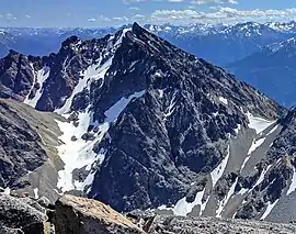 Mount Penrose seen from Dickson Peak | |
| Highest point | |
| Elevation | 2,634 m (8,642 ft) [1] |
| Prominence | 392 m (1,286 ft) [1] |
| Coordinates | 50°52′13″N 122°57′37″W [2] |
| Geography | |
 Mount Penrose  Mount Penrose Mount Penrose (Canada) | |
| Parent range | Dickson Range |
| Topo map | NTS 92/J15 |
| Climbing | |
| First ascent | Boies Penrose |
Climate
Based on the Köppen climate classification, Mount Penrose is located in a subarctic climate zone of western North America.[4] Most weather fronts originate in the Pacific Ocean, and travel east toward the Coast Mountains where they are forced upward by the range (Orographic lift), causing them to drop their moisture in the form of rain or snowfall. As a result, the Coast Mountains experience high precipitation, especially during the winter months in the form of snowfall. Temperatures can drop below −20 °C with wind chill factors below −30 °C. The months July through September offer the most favorable weather for climbing Mount Penrose.
References
- "Mount Penrose". Bivouac.com. Retrieved 2011-01-01.
- "Penrose, Mount". BC Geographical Names. Retrieved 2011-01-01.
- Tales from Seton Portage, Irene Edwards, self-publ. Lillooet, 1976]
- Peel, M. C.; Finlayson, B. L. & McMahon, T. A. (2007). "Updated world map of the Köppen−Geiger climate classification". Hydrol. Earth Syst. Sci. 11. ISSN 1027-5606.
External links
- Mt. Penrose weather: Mountain Forecast