Mount Samat
Mount Samat (Tagalog pronunciation: [samat]) is a mountain in the town of Pilar, Bataan, Philippines. Located near its summit is the Mount Samat National Shrine, a national shrine dedicated to the fallen Filipino and American fallen during World War II.
| Mount Samat | |
|---|---|
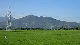 Mount Samat remote view | |
| Highest point | |
| Elevation | 544.7 m (1,787 ft) [1] |
| Parent peak | Mount Mariveles |
| Coordinates | 14°36′15.4″N 120°30′27.3″E |
| Geography | |
.svg.png.webp) Mount Samat Location within the Philippines | |
| Location | Luzon |
| Country | Philippines |
| Region | Central Luzon |
| Province | Bataan |
| Municipality | Pilar |
| Parent range | Zambales Mountains |
| Geology | |
| Mountain type | Extinct volcano |
| Volcanic arc/belt | Western Bataan Lineament |
| Last eruption | Unknown |
| Climbing | |
| Easiest route | Mt. Samat Road[1] |
Geology
Mount Samat is a parasitic cone of Mount Mariveles with no record of historical eruption. The summit of Mount Samat is 9.2 km (5.7 mi) NNE of the Mariveles caldera.[2] Mount Samat itself has a 550-metre (1,800 ft) wide crater that opens to the northeast. The Mount Samat Cross is situated near the edge of the crater rim.[1]
Historical significance
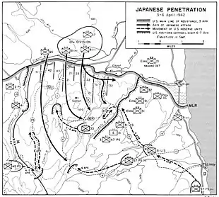
At the start of World War II in 1942 after suffering heavy losses against the Imperial Japanese Army all over Luzon, the Filipino and American soldiers retreated to Bataan Peninsula to regroup for a last valiant but futile stand. After four months of fighting, the 78,000 exhausted, sick and starving soldiers under Major General Edward P. King surrendered to the Japanese on April 9, 1942 known as the fall of Bataan. It is the single largest surrender of U.S. soldiers in history and Mariveles, a town in the Bataan province, was their last stronghold after which, together with the Philippine soldiers, they were led on to the 80-mile (130 km) march to Capas, Tarlac known as the Bataan Death March.
The Mount Samat National Shrine was erected as a fitting memorial to the heroic struggle and sacrifices of those soldiers who fought and died in that historic bastion of freedom.[3]
Dunsulan Falls
Dunsulan Falls (14°36′52.7″N 120°29′33.8″E) is a waterfall located at the foot of Mount Samat, northeast of the National Shrine in Brgy Liyang, also in Pilar town.[4] Dunsulan falls and river is the main drainage on the crater side of Mount Samat.
Images
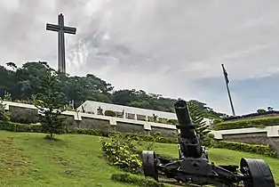 The 302-ft Dambana ng Kagitingan (Shrine of Valor) Memorial Cross located on the summit of Mount Samat
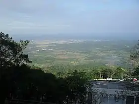 View from Mount Samat
References
- "Mount Samat, Cantral Luzon, Philippines". Google Maps. Retrieved on 2012-06-08.
- "Mariveles Synonyms & Subfeatures". Global Volcanism Program. Retrieved on 2012-06-08.
- Government of Province of Bataan (2006)."Dambana ng Kagitingan" Archived 2012-03-18 at the Wayback Machine. Bataan...A Raging Peninsula. Retrieved on 2011-03-27.
- "Historical trails: Mt. Samat". Pinoy Mountaineer. Retrieved on 2012-06-08.
External links
| Wikimedia Commons has media related to Mount Samat. |
- Photo of Dunsulan Falls from Panoramio