Bataan
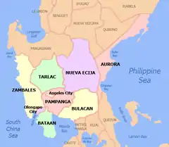
Bataan ( /bɑːtɑːˈɑːn/; Tagalog: Lalawigan ng Bataan IPA: [bataʔan]; Kapampangan: Lalauígan ning Bataan) is a province situated in the Central Luzon region of the Philippines. Its capital is Balanga. Occupying the entire Bataan Peninsula on Luzon, Bataan is bordered by the provinces of Zambales and Pampanga to the north. The peninsula faces the South China Sea to the west and Subic Bay to the north-west, and encloses Manila Bay to the east.
Bataan | |
|---|---|
| Province of Bataan | |
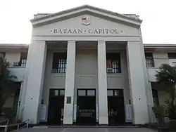 Bataan Provincial Capitol in Balanga | |
 Flag  Seal | |
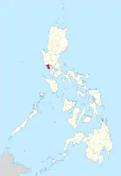 Location in the Philippines | |
| Coordinates: 14°41′06″N 120°25′55″E | |
| Country | Philippines |
| Region | Central Luzon (Region III) |
| Founded | 1754 |
| Capital | Balanga |
| Government | |
| • Type | Sangguniang Panlalawigan |
| • Governor | Albert Raymond S. Garcia (NUP) |
| • Vice Governor | Ma. Cristina M. Garcia (NUP) |
| Area | |
| • Total | 1,372.98 km2 (530.11 sq mi) |
| Area rank | 71st out of 81 |
| Highest elevation | 1,388 m (4,554 ft) |
| Population | |
| • Total | 760,650 |
| • Rank | 39th out of 81 |
| • Density | 550/km2 (1,400/sq mi) |
| • Density rank | 8th out of 81 |
| Divisions | |
| • Independent cities | 0 |
| • Component cities | 1
|
| • Municipalities | |
| • Barangays | 237 |
| • Districts | 1st and 2nd districts of Bataan |
| Demographics | |
| • Ethnic groups |
|
| • Languages | |
| Time zone | UTC+8 (PHT) |
| ZIP Code | 2100–2114 |
| IDD : area code | +63 (0)47 |
| ISO 3166 code | PH-BAN |
| Website | bataan |
The Battle of Bataan is famous in history as one of the last stands of American and Filipino soldiers before they were overwhelmed by the Japanese forces in World War II. The Bataan Death March was named after the province, where the infamous march started.
History
Classical Period
The first inhabitants of the Bataan peninsula are the Ayta Magbeken people, who are one of the first Negrito ancestors of present-day Filipinos. Later on, Tagalog communities from southern Luzon migrated to parts of Bataan and the Ayta Magbeken migrated towards the mountain areas of Bataan by the end of the 16th century.
Colonial Period
In 1647, Dutch naval forces landed in country in an attempt to seize the islands from Spain. The Dutch massacred the people of Abucay in Bataan.
Historian Cornelio Bascara documents that the province of Bataan was established on January 11, 1757 by Governor-General Pedro Manuel Arandia out of territories belonging to Pampanga and the corregimiento of Mariveles which, at the time, included Maragondon, Cavite across the Manila Bay.[3][4]
World War II
Bataan featured prominently during World War II. Prior to the 1941 Japanese invasion, Bataan was a military reservation for the purpose of defending the fortress island of Corregidor.[5]US Army stored nearly 1,000,000 US gallons (3,800 m3) of gasoline there, along with various munitions. At the southern tip of the peninsula the U.S. Navy had established a small base at the port of Mariveles.
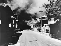
Shortly after the Japanese Army invaded the country in December 1941, the combined US and Filipino forces were being gradually overrun and General Douglas MacArthur moved his troops to the Bataan Peninsula in an attempt to hold out until a relief force could be sent from the US. Japanese forces started a siege of the peninsula on January 7, 1942, and launched an all-out assault on April 3, a few months after the Battle of the Points, Battle of the Pockets, the attack down Trail Number Two, and a half-dozen other brutal battles.[6] The Bataan campaign was the last time a regular cavalry unit of the U.S. Army, the Philippine Scouts 26th Cavalry, was used as a horse mounted fighting unit. On the morning of January 16, 1942, Lt. Edwin Ramsey led the last cavalry charge into the town of Moron, routing the advancing Japanese infantry.[7] Tragically, as the troops on Bataan were continually reduced in rations, the horses were eventually slaughtered to feed the starving soldiers.[8]
The majority of the American and Filipino forces surrendered on April 9 and were forced to march more than 100 kilometers (62 mi) from Bataan to Capas, Tarlac, which became known as the Bataan Death March.
Geography
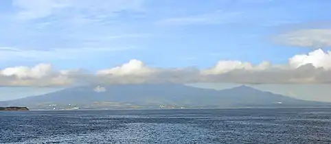
The province has an area of 1,372.98 square kilometres (530.11 sq mi),[9] and covers the entire Bataan Peninsula, a rocky extension of the Zambales Mountains jutting out into the South China Sea, enclosing the Manila Bay. At the northern portion of the peninsula is Mount Natib (elevation 1,253 metres (4,111 ft)) and its surrounding mountains, separated from Mount Samat and the Mariveles Mountains in the south by a pass.[4]
A narrow coastline plain characterizes the eastern portion of the province, while the western coast features many ridges, cliffs and headlands.[4]
Administrative divisions
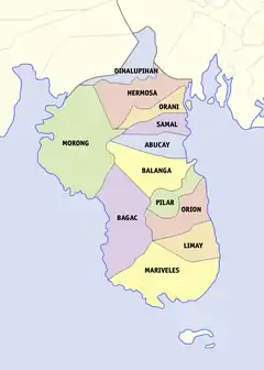
Bataan is politically subdivided into 11 municipalities and one component city.
| |||||||||||||||||||||||||||||||||||||||||||||||||||||||||||||||||||||||||||||||||||||||||||||||||||||||||||||||||||||||||||||||||||||||||||||||||||||||||||||||||||||||||||||||||||||||||||||||||||||||||
Demographics
|
| ||||||||||||||||||||||||||||||||||||||||||||||||
| Source: Philippine Statistics Authority [2] [10][11] | |||||||||||||||||||||||||||||||||||||||||||||||||
The population of Bataan in the 2015 census was 760,650 people, [2] with a density of 550 inhabitants per square kilometre or 1,400 inhabitants per square mile. The demonym for natives of the province is Bataeño.
Ethnicity
The three most prominent ethnic groups in Bataan are the Tagalogs, the Kapampangans and the Ayta Magbeken, though the third group has a lower population despite being the province's first inhabitants. The second group is mainly present at the northeast of the province, as well as in the provincial capital to a lesser extent.
Religion
Various religious groups are subscribed to by the people but Roman Catholicism is the predominant religion, comprising 85.46% of the Bataan population. Aglipayan, several other Christian and non-Christian faiths includes Iglesia ni Cristo (4.47%), Evangelivcals (2.06%), Aglipayans (1.60%) and other groups.
Education
Universities and colleges
- AMA Computer Learning Center – Balanga
- APG International Aviation Academy – Cubi Point, Subic Bay Freeport Zone, Morong
- Asia Pacific College of Advanced Studies (APCAS) – Balanga
- Bataan Heroes College – Balanga
- Bataan Maritime Institute – Balanga
- Bataan Peninsula State University – Abucay, Balanga, Dinalupihan, Orani
- Colegio de San Juan de Letran (branch campus) – Abucay
- College of Subic Montessori – Dinalupihan
- Eastwoods College of Science and Technology – Dinalupihan
- EastWoods Professional College of Science and Technology (formerly SOFTNET College of Science and Technology) – Balanga
- Fist Aviation Academy, Inc. – Cubi Point, Subic Bay Freeport Zone, Morong
- Limay Polytechnic College – Limay
- Manuel L. Quezon University – Balanga (under construction)
- Maritime Academy of Asia and the Pacific – Mariveles
- Microcity College of Business and Technology (Formerly: Microcity Computer College Foundation, Inc.) – Balanga
- Omni Aviation School – Cubi Point, Subic Bay Freeport Zone, Morong
- Philippine Women's University – CDCEC Bataan
- Polytechnic University of the Philippines – Mariveles
- St. Joseph College's of Balanga – Balanga
- Softnet Information Technology Center – Mariveles
- Thy Word International Bible College Extension – Mariveles
- Tomas del Rosario College – Balanga
- Tomas Pinpin Memorial Elementary School – Abucay
- TWI, Bethel Bible College Extension – Balanga
- University of Nueva Caceres – Dinalupihan
- Asia Pacific Collage of Advanced Studies- Balanga
Tourist attractions
Historical places
- Bataan Death March Marker (Orani)
- Bataan First Line of Defense (Layac, Dinalupihan)
- Filipino-Japanese Friendship Tower (Bagac)
- Limbagang Pinpin (Abucay)
- Mount Samat – Shrine of Valor (Pilar)
- World War II Museum (Balanga)
- Zero Kilometer Death March Marker (Mariveles and Bagac)
- The Flaming Sword (Pilar)
- Cayetano Arellano Monument and Hometown Marker (Orion)
Churches
- Nuestra Señora del Pilar Church – Morong
- Nuestra Señora del Pilar Church – Pilar
- Nuestra Señora, Virgen Milagrosa del Rosario Church – in Orani, it was conferred with the title Minor Basilica by Pope Francis on September 10, 2019. It is home to the miraculous image of the Our Lady of Orani which was canonically crowned 18 April 1959.
- San Francisco de Asis Church – Limay
- Diocesan Shrine and Cathedral-Parish of Saint Joseph – Balanga City, was declared as a diocesan-shrine and is the seat of the Diocese of Balanga
- San Juan Bautista Church – Dinalupihan
- San Miguel Arcangel Church – Orion
- San Nicolas de Tolentino Church – Mariveles
- San Pedro Martir de Verona Church – Hermosa
- Santa Catalina de Alexandria Church – Bagac
- Santa Catalina de Siena Church – Samal
- Santo Domingo de Guzman Church – Abucay, the oldest church in Bataan, established in 1587
Other places of interest
- Bataan Tourism Center – Balanga
- Las Casas Filipinas de Acuzar – Bagac
- Philippine Refugee Processing Center – Morong
- Ocean Adventure – Mabayo, Morong (SBFZ)
- Zoobic Safari – Mabayo, Morong (SBFZ)
- Major General Edward P. King (Grave) – Lamao
- Sinagtala Farm Resort & Adventure Park – Orani
- Vista Tala Resort & Recreational Park – Orani
- Camaya Coast (Camaya Sands Resorts and Leisure) – Mariveles
- Montemar Beach Club – Bagac
- Duhat Bike Trail – Orion
- GICC Technopark - Freeport Area of Bataan
- Pawikan Conservation Center - Morong
Natural places of interest
- Ambon-ambon (Lumutan) Falls (Binukawan, Bagac)
- Anvaya Cove (Morong)
- Balong Anito (Mariveles)
- Bataan National Park
- Camaya Coast (Mariveles)
- Dunsulan Falls(Pilar)
- Duhat Trail (Orion)
- Laki (Laque) Beach (Mariveles)
- Marilag Cove (Bagac)
- Mariveles Five Fingers (Mariveles)
- Mount Malasimbu (Dinalupihan)
- Mount Mariveles
- Mount Natib (Orani)
- Nagbintana Arc (Mariveles)
- Panoypoy Cove (Mariveles)
- Pasukulan Falls (Abucay)
- Playa La Caleta (Morong)
- Roosevelt Protected Landscape
- San Miguel Mountain Peak (Mariveles)
- Sibul Spring (Abucay)
- Sinagtala & Vista Tala (Orani)
- Talain Cove (Mariveles)
- Tarak Ridge (Mariveles)
- Tortugas Bay Park (Balanga)
Economy
| Poverty Incidence of Bataan | |
| Source: Philippine Statistics Authority[12][13][14][15][16][17][18] | |
Infrastructure
Generation
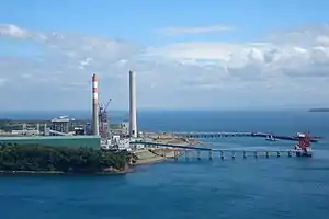
Bataan is a location of bulk power generation, where most of the power generated is sent to the Luzon Grid. Most power plants in Bataan rely on fossil fuels, like oil and coal, but renewable energy sources, primarily solar power, form part of the total generation. The total output of existing power plants equals to 2068.1 MW, and new power plants to start operation will increase the output to 4224.1 MW.
Fossil fuel-fired plants account for 2020 MW, and are mostly concentrated in Limay and Mariveles. These include the GN Power Mariveles Coal Power Plant, with 660 (2x330) MW, SMC Limay Greenfield Power Plant (4x150 MW), Petron Cogeneration Power Plant (4x35 MW), and Panasia Bataan Combined Cycle Power Plant (620 MW). Two plants under construction, the Dinginin Power Station (1,336 MW) and SMC Mariveles Coal Power Plant (4x150) will increase the capacity by 1936 MW.
Renewable energy, primarily solar power, accounts for 48.1 MW, and is concentrated on the northern part of the province. Existing renewable energy power plants include the Bataan 2020 Cogen Power Plant (12.5 MW), YH Green Energy Solar Power Plant (12.6 MW), Citicore Solar Power Plant (18 MW), and Morong Solar Power Plant (5 MW). Three projects, namely the Solana Solar Alpha Inc. (20 MW), Bataan Solar Power Project (150 MW), and Santa Rita Wind Power Project (50 MW), are set to increase the capacity by 220 MW.
The Bataan Nuclear Power Plant in Morong, with a design 600 MW capacity, was supposed to be the first nuclear power plant in the Philippines. It was supposed to commence operation in 1986, but was mothballed amidst critical opposition to the Marcos regime and concerns on nuclear power. There is some discussion of either rehabilitating the plant, which would likely be uneconomical, or constructing a new nuclear power station.
Distribution
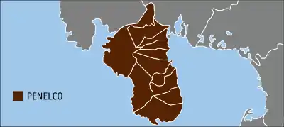
Power distribution in the province are served by the Peninsula Electric Cooperative (PENELCO), but some large customers have their power supply sourced from the transmission grid, operated by National Grid Corporation of the Philippines (NGCP), whose network of 69,000 volt lines supply substations owned by PENELCO. On Freeport Area of Bataan (FAB) and barangays Malaya and Maligaya, they are served by the National Transmission Corporation (TransCo) – FAB branch through its distribution facilities within the freeport.
Sea ports / terminals
- Mariveles Grain Terminal – Freeport Area of Bataan, Mariveles
- Seasia-Nectar Mariveles Dry Bulk Terminal – Freeport Area of Bataan, Mariveles
- Port of Lucanin – Mariveles
- Port of Lamao – Limay
- Port Capinpin – Orion
- Subic Bay International Container Port – Cubi Point, Subic Bay Freeport Zone, Morong
Starting late 2017, the 1Bataan Integrated Transport System had reactivated the ferry services from Esplanade at the Mall of Asia, Pasay City to Port Capinpin in Orion. The land travel that normally takes two and a half hours becomes one hour when one chooses to take the ferry. In addition, shuttles are available to bring the ferry disembarking at Orion to drop-off points heading towards Balanga, Bataan, or going towards the town of Mariveles.
Airport
- Subic Bay International Airport – Cubi Point, Subic Bay Freeport Zone, Morong
Highways, expressways and national roads
Bataan is served by a network of national highways and one expressway. Roman Superhighway, part of highway N301, and Jose Abad Santos Avenue, or highway N3 and Olongapo-Gapan Road, forms the backbone of the national highway network. Subic–Clark–Tarlac Expressway, a toll expressway, links the province with Pampanga and Tarlac. Bataan/Old National Road and Governor J.J. Linao National Road forms the secondary network, which connects the smaller municipalities with the main highway network.
Notable people
- Cayetano Arellano (Orion) – first Supreme Court Chief Justice of the Republic of the Philippines
- Francisco Baltazar (Orion) – one of the greatest Filipino literary laureates, born in Bigaa (Balagtas), Bulacan but spent his adult life in Orion, Bataan
- Luz Banzon (Balanga) – wife of Philippine President Ramon Magsaysay; seventh First Lady of the Philippines
- David Consunji (Samal) – chairman of publicly listed holding firm, DMCI Holdings, Incorporated
- Gary David (Dinalupihan) – basketball player and television actor/comedian
- Romi Garduce (Balanga) – mountain climber who reached the peak of Mount Everest
- Merceditas Gutierrez (Samal) – ombudsman, first female to head the post
- Norberto B. Gonzales[19] (Balanga) — 32nd and 34th Secretary of National Defense
- Manuel C. Herrera (Pilar) – Ombudsman, justice of the Court of Appeals and chair of the National Unification Commission
- Rodel Naval (Orion) – Filipino singer, songwriter and actor.
- Evangeline Pascual (Orani) – actress and First Runner-up Miss World 1973
- Felicito Payumo (Dinalupihan) – Chairman of the Subic Bay Metropolitan Authority from 1998 to 2004
- Ding Roman (Balanga) – Officer-in-Charge and Provincial Governor from 1986 to 2004
- Tomas Pinpin (Abucay) – printer, writer and publisher; first Filipino printer
- Kerby Raymundo (Orion) – basketball player
- Geraldine Roman (Orani) – journalist and politician; first transgender woman elected to Congress of the Philippines
- Tomas del Rosario (Orani) – judge, statesman and first governor of the province of Bataan from 1903 to 1905
- Mel Tiangco (Pilar) – popular television newscaster and television host; head of GMA Kapuso foundation
- Pedro Tuazon (Balanga) – Solicitor General of the Philippines, 1921
- Janine Tugonon (Orion) – model, TV host and beauty pageant titleholder- Miss Universe 2012 first runner-up
- Manuel Bamba Villar Jr. (Orani) – Senator, Republic of the Philippines
- Oscar V. Cruz (Balanga) – Archbishop Emeritus of the Roman Catholic Archdiocese of Lingayen-Dagupan
- Florita Rubiano-Villar (Samal) – Undersecretary, Department of Social Welfare and Development
- Alfredo Juinio (Limay) – Secretary Department of Public Works and Highways
- Manuel C. Sobreviñas (Dinalupihan) - Bishop Emeritus of the Roman Catholic Diocese of Imus
See also
- Bataan Provincial Expressway
- Petron Corporation (formerly known as Bataan Refining Corporation)
- Roman Catholic Diocese of Balanga
References
- "List of Provinces". PSGC Interactive. Makati City, Philippines: National Statistical Coordination Board. Archived from the original on 19 April 2016. Retrieved 5 March 2020.
- Census of Population (2015). "Region III (Central Luzon)". Total Population by Province, City, Municipality and Barangay. PSA. Retrieved 20 June 2016.
- Cornelio R. Bascara. 2010. A History of Bataan (1587–1900). UST Publishing
- Lancion, Jr., Conrado M.; cartography by de Guzman, Rey (1995). "The Provinces; Bataan". Fast Facts about Philippine Provinces (The 2000 Millenium ed.). Makati, Metro Manila, Philippines: Tahanan Books. p. 32. ISBN 971-630-037-9. Retrieved 4 December 2015.
- "Fall of the Philippines," Louis Morton
- "Bataan: Our Last Ditch," Lt. Col. John Whitman, USA.
- "The Battle of Bataan," Donald Young, p.66
- Intereviews 26th Cavalry, Jerry Kruth, researching Bataan, 2001.
- "Province: Bataan". PSGC Interactive. Quezon City, Philippines: Philippine Statistics Authority. Retrieved 8 January 2016.
- Census of Population and Housing (2010). "Region III (Central Luzon)". Total Population by Province, City, Municipality and Barangay. NSO. Retrieved 29 June 2016.
- "Philippines Census of Population of all LGUs 1903–2007". archive.org. Philippine Statistics Authority. Retrieved 14 February 2017.
- "Poverty incidence (PI):". Philippine Statistics Authority. Retrieved 28 December 2020.
- https://psa.gov.ph/sites/default/files/NSCB_LocalPovertyPhilippines_0.pdf; publication date: 29 November 2005; publisher: Philippine Statistics Authority.
- https://psa.gov.ph/sites/default/files/2009%20Poverty%20Statistics.pdf; publication date: 8 February 2011; publisher: Philippine Statistics Authority.
- https://psa.gov.ph/sites/default/files/Table%202.%20%20Annual%20Per%20Capita%20Poverty%20Threshold%2C%20Poverty%20Incidence%20and%20Magnitude%20of%20Poor%20Population%2C%20by%20Region%20and%20Province%20%20-%202006%2C%202009%2C%202012%20and%202015.xlsx; publication date: 27 August 2016; publisher: Philippine Statistics Authority.
- https://psa.gov.ph/sites/default/files/Table%202.%20%20Annual%20Per%20Capita%20Poverty%20Threshold%2C%20Poverty%20Incidence%20and%20Magnitude%20of%20Poor%20Population%2C%20by%20Region%20and%20Province%20%20-%202006%2C%202009%2C%202012%20and%202015.xlsx; publication date: 27 August 2016; publisher: Philippine Statistics Authority.
- https://psa.gov.ph/sites/default/files/Table%202.%20%20Annual%20Per%20Capita%20Poverty%20Threshold%2C%20Poverty%20Incidence%20and%20Magnitude%20of%20Poor%20Population%2C%20by%20Region%20and%20Province%20%20-%202006%2C%202009%2C%202012%20and%202015.xlsx; publication date: 27 August 2016; publisher: Philippine Statistics Authority.
- https://psa.gov.ph/sites/default/files/Table%202.%20%20Updated%20Annual%20Per%20Capita%20Poverty%20Threshold%2C%20Poverty%20Incidence%20and%20Magnitude%20of%20Poor%20Population%20with%20Measures%20of%20Precision%2C%20by%20Region%20and%20Province_2015%20and%202018.xlsx; publication date: 4 June 2020; publisher: Philippine Statistics Authority.
- http://www.dnd.gov.ph/norberto-b-gonzales.html
External links
 Media related to Bataan at Wikimedia Commons
 Geographic data related to Bataan at OpenStreetMap
- Bataan official website
