Mount Tsurugi (Tokushima)
Mount Tsurugi (剣山, Tsurugi-san), meaning sword, is a 1,954.7-metre-high (6,413.1 ft) mountain on the border of Miyoshi, Mima and Naka in Tokushima Prefecture, Japan. This mountain is one of the 100 Famous Japanese Mountains.
| Mount Tsurugi | |
|---|---|
| 剣山 | |
 | |
| Highest point | |
| Elevation | 1,954.7 m (6,413 ft) [1] |
| Prominence | 1,540 m (5,050 ft) [1] |
| Listing | Ultra |
| Coordinates | 33°51′13″N 134°05′39″E |
| Naming | |
| Language of name | Japanese |
| Geography | |
 Mount Tsurugi Japan | |
| Location | On the border of Miyoshi, Mima and Naka, Tokushima, Japan |
| Parent range | Shikoku Mountains |
| Geology | |
| Mountain type | Upheaval Peneplain |
Outline
Mount Tsurugi is the second highest mountain on the island of Shikoku, and also the second highest mountain west of Mount Haku, which is on the border of Ishikawa and Gifu prefectures in central Japan.
Mount Tsurugi is an important object of worship in this region and one of the centers of Shugendō, a sect of mixture of Shintoism and Buddhism. On the top of the mountain, there is a small shrine called ‘Tsurugi Jinja’.
The area around Mount Tsurugi is a major part of Tsurugi Quasi-National Park.
Climate
Mount Tsurugi has an altitude-affected humid continental climate (Köppen climate classification Dfb) with mild summers and cold winters.
| Climate data for Mount Tsurugi | |||||||||||||
|---|---|---|---|---|---|---|---|---|---|---|---|---|---|
| Month | Jan | Feb | Mar | Apr | May | Jun | Jul | Aug | Sep | Oct | Nov | Dec | Year |
| Average high °C (°F) | −4.1 (24.6) |
−3.1 (26.4) |
0.5 (32.9) |
7.1 (44.8) |
11.4 (52.5) |
14.4 (57.9) |
17.9 (64.2) |
18.2 (64.8) |
15.2 (59.4) |
9.8 (49.6) |
5.0 (41.0) |
−0.8 (30.6) |
7.6 (45.7) |
| Daily mean °C (°F) | −7.3 (18.9) |
−6.6 (20.1) |
−3.3 (26.1) |
3.3 (37.9) |
7.7 (45.9) |
11.3 (52.3) |
15.1 (59.2) |
15.3 (59.5) |
12.1 (53.8) |
6.3 (43.3) |
1.3 (34.3) |
−4.3 (24.3) |
4.2 (39.6) |
| Average low °C (°F) | −10.3 (13.5) |
−9.9 (14.2) |
−6.9 (19.6) |
−0.3 (31.5) |
4.3 (39.7) |
8.6 (47.5) |
12.9 (55.2) |
13.2 (55.8) |
9.6 (49.3) |
3.3 (37.9) |
−1.9 (28.6) |
−7.3 (18.9) |
1.3 (34.3) |
| Average snowfall cm (inches) | 87 (34) |
89 (35) |
72 (28) |
17 (6.7) |
0 (0) |
0 (0) |
0 (0) |
0 (0) |
0 (0) |
1 (0.4) |
11 (4.3) |
48 (19) |
325 (127.4) |
| Average relative humidity (%) | 81 | 81 | 80 | 76 | 75 | 85 | 90 | 91 | 89 | 80 | 76 | 78 | 82 |
| Mean monthly sunshine hours | 112.1 | 110.7 | 145.7 | 157.6 | 168.7 | 112.3 | 110.5 | 113.8 | 99.0 | 128.5 | 123.5 | 122.6 | 1,505 |
| Source: NOAA (1961-1990) [2] | |||||||||||||
Access
- The main trailhead, along with parking lots, shops and restaurants, is located at Minokoshi, at the intersection of national routes 438 and 439. From Minokoshi, climbers may also ride a chairlift to a higher point on the trail.
- Trails link the summit of Mount Tsurugi to neighboring mountains. Tsurugi can be reached from the east via Ichinomori, while an extensive network of trails to the west allows access from mountains such as Jirogyu, Miune, and Tengu-zuka.
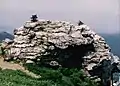 Tsurugi Jinja (Tsurgi Shrine) on the top of Mount Tsurugi
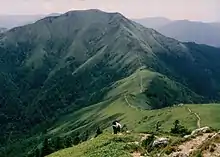 Mount Jirogyu from the top of Mount Tsurugi
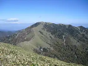
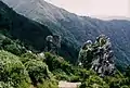 A view of the middle of Mount Tsurugi
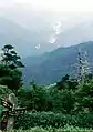 Another view of the middle of Mount Tsurugi
See also
- List of Ultras of Japan
- Tsurugisan (train), a train service named after Mount Tsurugi in Tokushima
References
- "Japan Ultra-Prominences". Peaklist.org. Retrieved 2013-03-23.
- "Tsurugisan Climate Normals 1961-1990". National Oceanic and Atmospheric Administration. Retrieved January 7, 2013.
External links
| Wikimedia Commons has media related to Mount Tsurugi (Tokushima). |
- the Geographical Survey Institute in Japan
- Tsurugi Quasi-National Park
- ‘Ishizuchi Shinko Tsurugisan’
- "Tsurugi-san, Japan" on Peakbagger
| Hokkaidō | |||||||||
|---|---|---|---|---|---|---|---|---|---|
| Tōhoku region Jōshinetsu region |
| ||||||||
| Kantō region | |||||||||
| Chūbu region |
| ||||||||
| Western Japan | |||||||||
| |||||||||
| Authority control |
|---|