Mount Wellington, New Zealand
Mount Wellington is a suburb in East Auckland, New Zealand, located 10 kilometres southeast of the city centre. It is surrounded by the suburbs of Stonefields, Tamaki, Panmure, Penrose, and Ellerslie, and by the Tamaki River. The suburb is named after the volcanic peak of Maungarei / Mount Wellington. Sylvia Park is a large business park and shopping centre located in the suburb.
Mount Wellington | |
|---|---|
Suburb | |
 | |

| |
| Country | New Zealand |
| Local authority | Auckland Council |
| Electoral ward | Maungakiekie-Tāmaki Ward |
| Local board | Maungakiekie-Tamaki |
| Population (2018) | |
| • Total | 25,218 |
| Train station(s) | Sylvia Park Railway Station |
| Ellerslie, St. John's Park, Panmure | ||
| Penrose |
|
Tamaki River, Pakuranga, Panmure |
| Westfield | Panmure |
Geography
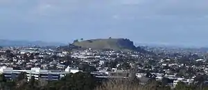
Maungarei / Mount Wellington is a 135-metre[1] volcanic peak of the Auckland volcanic field. It is the youngest onshore volcano of the Auckland volcanic field, having been formed by an eruption around 10,000 years ago. It is the largest of Auckland's scoria cones.[2] Prior to European settlement, the area around Maungarei was bracken scrub and not densely forested.[3]
Demographics
| Year | Pop. | ±% p.a. |
|---|---|---|
| 2006 | 21,156 | — |
| 2013 | 23,283 | +1.38% |
| 2018 | 25,218 | +1.61% |
| Source: [4] | ||
Mount Wellington, comprising the statistical areas of Mount Wellington North West, Mount Wellington North East, Mount Wellington Ferndale, Mount Wellington East, Mount Wellington West, Mount Wellington Central, Sylvia Park, Mount Wellington South West and Mount Wellington South East, had a population of 25,218 at the 2018 New Zealand census, an increase of 1,935 people (8.3%) since the 2013 census, and an increase of 4,062 people (19.2%) since the 2006 census. There were 7,914 households. There were 12,558 males and 12,657 females, giving a sex ratio of 0.99 males per female, with 4,716 people (18.7%) aged under 15 years, 6,246 (24.8%) aged 15 to 29, 11,397 (45.2%) aged 30 to 64, and 2,859 (11.3%) aged 65 or older.
Ethnicities were 38.8% European/Pākehā, 11.7% Māori, 21.6% Pacific peoples, 37.5% Asian, and 3.0% other ethnicities (totals add to more than 100% since people could identify with multiple ethnicities).
The proportion of people born overseas was 47.5%, compared with 27.1% nationally.
Although some people objected to giving their religion, 33.1% had no religion, 43.6% were Christian, and 18.2% had other religions.
Of those at least 15 years old, 5,919 (28.9%) people had a bachelor or higher degree, and 2,790 (13.6%) people had no formal qualifications. The employment status of those at least 15 was that 11,424 (55.7%) people were employed full-time, 2,298 (11.2%) were part-time, and 873 (4.3%) were unemployed.[4]
Economy
Retail
The Sylvia Park shopping centre opened in 2006,[5] and an upgrade opened in 2020.[6] The mall has 106,427 m2 of lettable space spread across two floors,[5] alongside 4,053 carparks.[7] Its 250 stores include anchor tenants The Warehouse, Farmers, Kmart, Pak'nSave and a 10-screen Hoyts Cinema.[8]
Mt Wellington Shopping Centre has 22 stores spread across 9,000 m2, including anchor tenants Countdown and Supercheap Auto.[9]
Education
Bailey Road School, Stanhope Road School and Sylvia Park School are state full primary schools (years 1–8) with rolls of 447, 545 and 483 students, respectively.[10][11][12]
Panama Road School is a contributing primary school (years 1–6) with a roll of 231 students.[13]
All these school are coeducational. Rolls are as of March 2020.[14]
References
- "Archived copy". Archived from the original on 11 February 2009. Retrieved 5 March 2009.CS1 maint: archived copy as title (link)
- "Volcanoes of Auckland: Mt Wellington". Auckland Regional Council. Archived from the original on 11 February 2009. Retrieved 5 March 2009.
- Leahy, Anne (1991). "EXCAVATIONS AT TAYLOR'S HILL, R11/96, AUCKLAND". Records of the Auckland Institute and Museum. 28: 33–68. ISSN 0067-0464.
|access-date=requires|url=(help) - "Statistical area 1 dataset for 2018 Census". Statistics New Zealand. March 2020. Mount Wellington North West (145300), Mount Wellington North East (146000), Mount Wellington Ferndale (146200), Mount Wellington East (146500), Mount Wellington West (146600), Mount Wellington Central (147200), Sylvia Park (147400), Mount Wellington South West (149100) and Mount Wellington South East (149500). 2018 Census place summary: Mount Wellington North West 2018 Census place summary: Mount Wellington North East 2018 Census place summary: Mount Wellington Ferndale 2018 Census place summary: Mount Wellington East 2018 Census place summary: Mount Wellington West 2018 Census place summary: Mount Wellington Central 2018 Census place summary: Sylvia Park 2018 Census place summary: Mount Wellington South West 2018 Census place summary: Mount Wellington South East
- Nadkarni, Anjua (15 October 2020). "Sylvia Park opens new $277 million shopping floor with new stores". stuff.co.nz.
- Nadkarni, Anuja (15 October 2020). "Sylvia Park opens new $277 million shopping floor with new stores". stuff.co.nz.
- "Sylvia Park". kiwiproperty.com. Kiwi Property Group.
- "Sylvia Park Stores". kiwiproperty.com. Kiwi Property Group.
- "Special Meeting of Shareholders 2020" (PDF). investoreproperty.co.nz. Investore Property. 16 January 2020.
- Education Counts: Bailey Road School
- Education Counts: Stanhope Road School
- Education Counts: Sylvia Park School
- Education Counts: Panama Road School
- "New Zealand Schools Directory". New Zealand Ministry of Education. Retrieved 26 April 2020.
- Volcanoes of Auckland: The Essential guide - Hayward, B.W., Murdoch, G., Maitland, G.; Auckland University Press, 2011.
External links
- Bailey Road School
- Stanhope school
- Sylvia Park School
- Photographs of Mount Wellington held in Auckland Libraries' heritage collections.