Panmure, New Zealand
Panmure is an east Auckland suburb, in the North Island of New Zealand. It is located 11 kilometres southeast of the Auckland CBD, close to the western banks of the Tamaki River and the northern shore of the Panmure Basin (or Kaiahiku). To the north lies the suburb of Tamaki, and to the west is the cone of Maungarei / Mount Wellington.
Panmure | |
|---|---|
Suburb | |
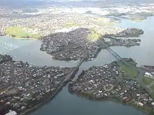 View of Panmure | |

| |
| Country | New Zealand |
| Local authority | Auckland Council |
| Electoral ward | Maungakiekie-Tāmaki Ward |
| Local board | Maungakiekie-Tāmaki Local Board |
| Board subdivision | Tamaki |
| Established | 1848 (European)[1] |
| Population (2018)[2] | |
| • Total | 3,651 |
| Train station(s) | Panmure Train Station |
| Stonefields | Tamaki, Point England | (Tamaki River) |
| Mount Wellington |
|
(Tamaki River) |
| Mount Wellington | Mount Wellington | Pakuranga |
Demographics
| Year | Pop. | ±% p.a. |
|---|---|---|
| 2006 | 2,919 | — |
| 2013 | 3,258 | +1.58% |
| 2018 | 3,651 | +2.30% |
| Source: [2] | ||
Panmure, comprising the statistical areas of Panmure West and Panmure East, had a population of 3,651 at the 2018 New Zealand census, an increase of 393 people (12.1%) since the 2013 census, and an increase of 732 people (25.1%) since the 2006 census. There were 1,257 households. There were 1,839 males and 1,815 females, giving a sex ratio of 1.01 males per female, with 594 people (16.3%) aged under 15 years, 891 (24.4%) aged 15 to 29, 1,644 (45.0%) aged 30 to 64, and 525 (14.4%) aged 65 or older.
Ethnicities were 41.6% European/Pākehā, 14.1% Māori, 20.7% Pacific peoples, 35.0% Asian, and 3.4% other ethnicities (totals add to more than 100% since people could identify with multiple ethnicities).
The proportion of people born overseas was 45.9%, compared with 27.1% nationally.
Although some people objected to giving their religion, 35.5% had no religion, 44.0% were Christian, and 15.0% had other religions.
Of those at least 15 years old, 840 (27.5%) people had a bachelor or higher degree, and 450 (14.7%) people had no formal qualifications. The employment status of those at least 15 was that 1,629 (53.3%) people were employed full-time, 345 (11.3%) were part-time, and 144 (4.7%) were unemployed.[2]
History
The Maori name for the area was Tauoma.[3] One of the traditional portages between the Waitematā Harbour and the Manukau Harbour was near here. 4.6 km up the Tamaki River Maori would beach their waka (canoes) at the end of a small creek (that now passes under the southern motorway) and drag them overland (where Portage Road is now) to the Manukau harbour.
During the Musket wars in late September 1821, Mokaia Pa was the scene of severe fighting and was sacked by 4000 musket carrying warriors such as Nga Puhi from the north led by Hongi Hika.[1] The fighting devastated what had been the Ngāti Pāoa population centre of the Auckland Isthmus during pre-European times which had a population of about 7,000.[1] Three thousand men with up to 100 muskets took part in the defence of the Pa but after a close and bitter battle were defeated by the combined northern alliance who had between 500 and 1000 muskets.[4] Mokaia Pa, on the headland to the east of the Panmure lagoon, was visited in 1820 by the missionary Samuel Marsden.
In 1841, the Government bought the Kohimaramara block from Ngati Paoa. In January 1842 Felton Mathew surveyed "Tehmaki" into 37 farms totalling 3,856 acres. Part of this became the Fencible settlement of Panmure, between Maungarei and the Tamaki River. In 1848, 80 Fencible families came here from Ireland and England on the ship Clifton and established a settlement with 99 raupo huts on the eastern shores of the lagoon. They called the area Maggotty Hollow. Located on the Tamaki River, Panmure was favoured by Felton Mathew to be the new capital of New Zealand. William Hobson, however, decided otherwise, and the new town of Auckland arose further to the west along the shores of the Waitematā Harbour.
Panmure was then instead created as a fencible settlement, where retired soldiers were contracted to defend the settlement in return for land. The soldiers had to give 12 days military service per year and parade on Sunday in full military equipment. The only time they were called to arms was in 1851 when a flotilla of 20 waka took about 350 warriors to Mechanics Bay to attack Auckland. The Panmure fencibles were issued ammunition to defend the Tamaki River and stop any armed Maori attack. Only the Onehunga fencibles were marched to the hill over looking Mechanics Bay to join a British line regiment. In the 1863 attack on Auckland the government used mainly professional soldiers instead.[1][5]
Panmure was an important town and port as it was strategically placed near the narrowest part of the isthmus, and during the New Zealand Wars of the 1860s it became a very busy place. Even after the railway reached Auckland in 1908, Panmure somewhat continued as a transport hub – steamers from Auckland en route to the goldfields in the Coromandel and Firth of Thames would call in here. Panmure prospered partly due to being on the route between Auckland and the much larger fencibles settlement of Howick in the 1800s. People and goods used the ferry at the narrow point below Mokoia Pa.[6]
Until about the middle of the 20th century, Panmure remained a prosperous but mostly pastoral setting, the smallest borough of Auckland, and described as "a quarter of a square mile of farmlets surrounding a sleepy village that boasted little more than a church, post office, a handful of shops, and a two-storey hotel that was widely known from horse and buggy days".[1] Panmure Township merged with Mount Wellington Borough in 1955.[7]
It was only with the explosive growth of suburbia around it after World War II, and better bridges to Pakuranga that Panmure relatively suddenly started to grow significantly, and become a commercial centre.[1]
Recent developments
Work was completed on the Panmure section (Stage 1) of the Auckland Transport project called AMETI (Auckland-Manukau Eastern Transport Initiative) which aims to improve the connections of eastern Auckland towards the south-east (Manukau central).[8] As part of this, Panmure railway station underwent a major upgrade, increasing capacity and frequency of trains into the city (now a 17-minute travel time to Britomart station). The new Te Horeta Rd, the last major milestone, opened on 2 November 2015. Other related upgrades included the building of three new bridges, new cycle paths and foot paths.
Stage 2 of AMETI will see the completion of the 7 km Eastern Busway which will link Panmure railway station with Pakuranga and Botany. This is expected to cut public transport journey times significantly and relieve congestion on roads. The busway is expected to attract 5.5 million passengers a year.[9] The Panmure Roundabout will become an intersection, a change that will see new investment in the redevelopment of the land adjacent to and north of the rail station.
The Tamaki Transformation Programme was announced in early 2012 by Housing Minister Phil Heatley. This will be the country's first urban regeneration programme. Heatley said that east Auckland was chosen because it was an area with "significant potential". "It is close to the Auckland and Manukau central business districts. It has a young population, a sense of history and community, green spaces and near-coastal location". Following this announcement, Auckland Council and the New Zealand government formed the Tamaki Redevelopment Company to deliver the Tamaki Transformation Programme with the aim of creating a "thriving, attractive, sustainable and self-reliant community through a series of interlinking and complimentary [sic] economic, social, urban space and housing projects".[10] Substantial Central and Local Government partnership investment into the Tamaki Regeneration Programme will see change over the next 25 years, aiming to improve the overall quality of life to the residents of Tamaki with an expected doubling of the population in this area.
Education
Panmure Bridge School and Panmure District School are full primary schools (years 1-8) with rolls of 212 and 113 students, respectively.[11][12]
St Patrick's School is a state-integrated Cataholic full primary school (years 1-8) with a roll of 100.[13]
Atea College is a private Christian composite school (years 1-13) with a roll of 11.[14]
All these schools are coeducational. Rolls are as of March 2020.[15]
Notable buildings
- St Matthias' Church (Anglican)[16]
See also
- William Dwane Bell, who killed three people at the Panmure RSA in 2001.
References
- "Auckland: Soldiers of fortune". The New Zealand Herald. 26 August 2010. Retrieved 5 February 2011.
- "Statistical area 1 dataset for 2018 Census". Statistics New Zealand. March 2020. Panmure West (146700) and Panmure East (147100). 2018 Census place summary: Panmure West 2018 Census place summary: Panmure East
- The Royal New Zealand Fencibles. R. Alexander. G Gibson. A LaRoche. Deed. Waiuku .1997. pp71-75
- P24=26 Cannibal Jack. T Bentley
- The Royal NZ Fencibles. pp75-85
- Royal NZ Fencibles.pp75-85.
- Bush, G. W. A. (1971). Decently and in Order: The Centennial History of the Auckland City Council. Collins. p. 404.
- http://www.aucklandtransport.govt.nz/improving-transport/current-projects/01IntegratedTravel/Pages/AMETI-Panmure.aspx
- http://www.voxy.co.nz/national/new-busway-congested-eastern-roads/5/120721
- http://www.stuff.co.nz/auckland/local-news/7599791/Boss-ready-to-transform-eastern-suburbs
- Education Counts: Panmure Bridge School
- Education Counts: Panmure District School
- Education Counts: St Patrick's School
- Education Counts: Atea College
- "New Zealand Schools Directory". New Zealand Ministry of Education. Retrieved 26 April 2020.
- "St Matthias' Church (Anglican)". Register of Historic Places. Heritage New Zealand. Retrieved 27 January 2021.
External links
- Photographs of Panmure held in Auckland Libraries' heritage collections.