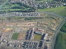
Stonefields
Stonefields is a suburb in East Auckland, New Zealand, located 8 kilometres southeast of the city centre.[3]
Stonefields | |
|---|---|
Suburb | |

| |
| Country | New Zealand |
| Local authority | Auckland Council |
| Electoral ward | Ōrākei Ward |
| Local board | Ōrākei Local Board |
| Population (2018)[1] | |
| • Total | 3,792 |
| Postcode(s) | 1072[2] |
| Meadowbank (3.5 km) | St Johns (3.3 km) | Glen Innes (2.7 km) |
| Greenlane (5.9 km) |
|
Tamaki (3.3 km) |
| Ellerslie (4.6 km) | Mt Wellington (4.6 km) | Panmure (3.5 km) |
Stonefields is surrounded by the suburbs of Mount Wellington, Saint Johns and Glen Innes.
Demographics
| Year | Pop. | ±% p.a. |
|---|---|---|
| 2006 | 0 | — |
| 2013 | 2,043 | — |
| 2018 | 3,792 | +13.17% |
| Source: [1] | ||
Stonefields, comprising the statistical areas of Stonefields West and Stonefields East, had a population of 3,792 at the 2018 New Zealand census, an increase of 1,749 people (85.6%) since the 2013 census, and an increase of 3,792 people since the 2006 census. There were 1,425 households. There were 1,782 males and 2,010 females, giving a sex ratio of 0.89 males per female, with 744 people (19.6%) aged under 15 years, 708 (18.7%) aged 15 to 29, 1,857 (49.0%) aged 30 to 64, and 480 (12.7%) aged 65 or older.
Ethnicities were 63.9% European/Pākehā, 3.6% Māori, 1.7% Pacific peoples, 34.3% Asian, and 3.2% other ethnicities (totals add to more than 100% since people could identify with multiple ethnicities).
The proportion of people born overseas was 42.6%, compared with 27.1% nationally.
Although some people objected to giving their religion, 47.5% had no religion, 36.3% were Christian, and 12.0% had other religions.
Of those at least 15 years old, 1,542 (50.6%) people had a bachelor or higher degree, and 186 (6.1%) people had no formal qualifications. The employment status of those at least 15 was that 1,854 (60.8%) people were employed full-time, 369 (12.1%) were part-time, and 69 (2.3%) were unemployed.[1]
Education
Stonefields School is a coeducational full primary (years 1-8) school with a roll of 671 as of March 2020.[4][5]
References
- "Statistical area 1 dataset for 2018 Census". Statistics New Zealand. March 2020. Stonefields West (144900) and Stonefields East (145700). 2018 Census place summary: Stonefields West 2018 Census place summary: Stonefields East
- "Garin Way, Stonefields, Auckland – Postcode – 1072". New Zealand Postcode Search. Retrieved 16 September 2018.
- "Old Quarry site turns into Stonefields". Stuff.co.nz. 29 January 2009. Retrieved 12 September 2018.
- "New Zealand Schools Directory". New Zealand Ministry of Education. Retrieved 26 April 2020.
- Education Counts: Stonefields School