Murdock, Minnesota
Murdock is a town in Swift County, Minnesota, United States. The population was 278 at the 2010 census.[6] The city is part of the Kerhoven-Murdock-Sunburg (KMS) school district. Murdock has Kerkhoven-Murdock-Sunburg Elementary School which is for grades PreK-5.
Murdock | |
|---|---|
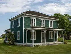 The Sabin S. Murdock House is on the National Register of Historic Places. | |
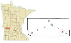 Location of Murdock, Minnesota | |
| Coordinates: 45°13′26″N 95°23′32″W | |
| Country | United States |
| State | Minnesota |
| County | Swift |
| Area | |
| • Total | 0.70 sq mi (1.82 km2) |
| • Land | 0.70 sq mi (1.82 km2) |
| • Water | 0.00 sq mi (0.00 km2) |
| Elevation | 1,089 ft (332 m) |
| Population | |
| • Total | 278 |
| • Estimate (2019)[3] | 263 |
| • Density | 373.58/sq mi (144.30/km2) |
| Time zone | UTC-6 (Central (CST)) |
| • Summer (DST) | UTC-5 (CDT) |
| ZIP code | 56271 |
| Area code(s) | 320 |
| FIPS code | 27-44818[4] |
| GNIS feature ID | 0648389[5] |
| Website | City website |
History
A post office has been in operation at Murdock since 1878.[7] Murdock was platted in 1881 by S. S. Murdock, and named for him.[8] Murdock was incorporated in 1881.[8]
On December 9, 2020, the Murdock City Council voted to allow the Asatru Folk Assembly to use a former church as its gathering place.[9][10]
Geography
According to the United States Census Bureau, the city has a total area of 0.56 square miles (1.45 km2), all land.[11]
U.S. Route 12 serves as a main route in the community.
Demographics
| Historical population | |||
|---|---|---|---|
| Census | Pop. | %± | |
| 1890 | 130 | — | |
| 1900 | 275 | 111.5% | |
| 1910 | 288 | 4.7% | |
| 1920 | 391 | 35.8% | |
| 1930 | 326 | −16.6% | |
| 1940 | 334 | 2.5% | |
| 1950 | 393 | 17.7% | |
| 1960 | 381 | −3.1% | |
| 1970 | 358 | −6.0% | |
| 1980 | 343 | −4.2% | |
| 1990 | 282 | −17.8% | |
| 2000 | 303 | 7.4% | |
| 2010 | 278 | −8.3% | |
| 2019 (est.) | 263 | [3] | −5.4% |
| U.S. Decennial Census[12] | |||
2010 census
As of the census[2] of 2010, there were 278 people, 117 households, and 74 families living in the city. The population density was 496.4 inhabitants per square mile (191.7/km2). There were 131 housing units at an average density of 233.9 per square mile (90.3/km2). The racial makeup of the city was 95.0% White, 4.0% from other races, and 1.1% from two or more races. Hispanic or Latino of any race were 7.2% of the population.
There were 117 households, of which 32.5% had children under the age of 18 living with them, 47.9% were married couples living together, 9.4% had a female householder with no husband present, 6.0% had a male householder with no wife present, and 36.8% were non-families. 33.3% of all households were made up of individuals, and 12.8% had someone living alone who was 65 years of age or older. The average household size was 2.38 and the average family size was 3.07.
The median age in the city was 37.4 years. 27% of residents were under the age of 18; 7% were between the ages of 18 and 24; 27.8% were from 25 to 44; 28.1% were from 45 to 64; and 10.4% were 65 years of age or older. The gender makeup of the city was 48.2% male and 51.8% female.
2000 census
As of the census[4] of 2000, there were 303 people, 126 households, and 77 families living in the city. The population density was 538.5 people per square mile (208.9/km2). There were 150 housing units at an average density of 266.6 per square mile (103.4/km2). The racial makeup of the city was 95.05% White, 0.66% African American, 3.96% from other races, and 0.33% from two or more races. Hispanic or Latino of any race were 8.25% of the population.
There were 126 households, out of which 32.5% had children under the age of 18 living with them, 49.2% were married couples living together, 11.1% had a female householder with no husband present, and 38.1% were non-families. 34.9% of all households were made up of individuals, and 17.5% had someone living alone who was 65 years of age or older. The average household size was 2.40 and the average family size was 3.15.
In the city, the population was spread out, with 30.0% under the age of 18, 7.9% from 18 to 24, 27.1% from 25 to 44, 14.5% from 45 to 64, and 20.5% who were 65 years of age or older. The median age was 35 years. For every 100 females, there were 98.0 males. For every 100 females age 18 and over, there were 96.3 males.
The median income for a household in the city was $28,750, and the median income for a family was $40,000. Males had a median income of $25,781 versus $16,477 for females. The per capita income for the city was $17,011. About 8.3% of families and 7.4% of the population were below the poverty line, including 10.1% of those under the age of eighteen and 6.5% of those 65 or over.
Notable people
- Andrew Falk - Former state representative
- David Frederickson - Commissioner of the Minnesota Department of Agriculture
References
- "2019 U.S. Gazetteer Files". United States Census Bureau. Retrieved July 26, 2020.
- "U.S. Census website". United States Census Bureau. Retrieved 2012-11-13.
- "Population and Housing Unit Estimates". United States Census Bureau. May 24, 2020. Retrieved May 27, 2020.
- "U.S. Census website". United States Census Bureau. Retrieved 2008-01-31.
- "US Board on Geographic Names". United States Geological Survey. 2007-10-25. Retrieved 2008-01-31.
- "2010 Census Redistricting Data (Public Law 94-171) Summary File". American FactFinder. U.S. Census Bureau, 2010 Census. Retrieved 23 April 2011.
- "Swift County". Jim Forte Postal History. Retrieved 9 August 2015.
- Upham, Warren (1920). Minnesota Geographic Names: Their Origin and Historic Significance. Minnesota Historical Society. p. 541.
- Marohn, Kirsti (9 December 2020). "Murdock votes to allow whites-only group to use former church". MPR News. Retrieved 10 December 2020.
- "After permit approved for whites-only church, small Minnesota town insists it isn't racist". NBC News. Retrieved 2020-12-22.
- "US Gazetteer files 2010". United States Census Bureau. Archived from the original on 2012-01-25. Retrieved 2012-11-13.
- "Census of Population and Housing". Census.gov. Retrieved June 4, 2015.
Municipalities and communities of Swift County, Minnesota, United States | ||
|---|---|---|
| Cities | 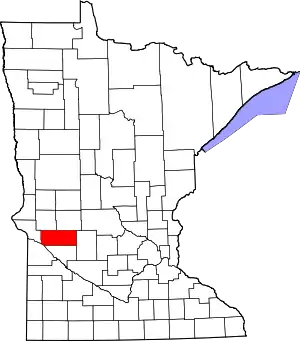 Map of Minnesota highlighting Swift County | |
| Townships | ||
| Unincorporated communities | ||
| ||