Swift County, Minnesota
Swift County is a county in the U.S. state of Minnesota. As of the 2010 United States Census, the population was 9,783.[3] Its county seat is Benson.[4]
Swift County | |
|---|---|
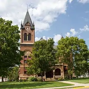 Swift County Courthouse, Benson | |
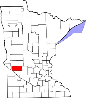 Location within the U.S. state of Minnesota | |
 Minnesota's location within the U.S. | |
| Coordinates: 45°17′N 95°41′W | |
| Country | |
| State | |
| Founded | February 18, 1870[1] |
| Named for | Henry Adoniram Swift[2] |
| Seat | Benson |
| Largest city | Benson |
| Area | |
| • Total | 752 sq mi (1,950 km2) |
| • Land | 742 sq mi (1,920 km2) |
| • Water | 8.82 sq mi (22.8 km2) 1.3%% |
| Population (2010) | |
| • Total | 9,783 |
| • Estimate (2019) | 9,266 |
| • Density | 12.7/sq mi (4.9/km2) |
| Time zone | UTC−6 (Central) |
| • Summer (DST) | UTC−5 (CDT) |
| Congressional district | 7th |
| Website | www |
History
Swift County is in west central Minnesota and consists of 757 square miles (2,000 km2) with three tiers of seven townships each. It was established on February 18, 1870, and named for Henry Adoniram Swift, the third governor of Minnesota (1863–64).
The Indians had grievances against the government, including delays in sending annuities that caused near starvation several times. In August 1862, an Indian rebellion broke out in Minnesota. The warfare reached the settlements just getting started in northeastern Swift County. By late September 1862, the Indian War was almost over but the settlers hesitated to venture back to Swift County until 1865, when all danger was apparently over. Scandinavians and Germans were in decided majority among the early settlers. A number of them came with the honor and privileges of Civil War veterans.
In 1869, the St. Paul & Pacific Railroad reached Willmar, and the next year it arrived in Benson. The railroad company determined the number of future trading centers (Kerkhoven, DeGraff, Benson, Randall) in the county by locating sites at intervals of approximately 8 miles (13 km). The Swift County Courthouse was built in 1897 and was listed on the National Register of Historic Places in 1976. Benson is the county seat. Railroad tracks run through Benson's downtown business district with parks on each side.
Historic buildings
Historic buildings in Swift County include:
- Gethsemane Episcopal Church in Appleton built in 1879 and listed on the National Register of Historic Places in 2011.
Politics
Swift County was traditionally a Democratic stronghold, with the last Republican to win it before 2016 being Dwight D. Eisenhower in 1952.[5] A dramatic swing against the Democrats in the Rust Belt saw Donald Trump win the county over Hillary Clinton by 26%.
| Year | Republican | Democratic | Third parties |
|---|---|---|---|
| 2020 | 63.9% 3,316 | 34.6% 1,784 | 1.8% 93 |
| 2016 | 59.3% 2,963 | 33.8% 1,686 | 6.9% 345 |
| 2012 | 43.9% 2,248 | 53.7% 2,751 | 2.3% 120 |
| 2008 | 41.7% 2,184 | 55.4% 2,907 | 2.9% 153 |
| 2004 | 43.3% 2,481 | 55.2% 3,165 | 1.6% 89 |
| 2000 | 43.7% 2,376 | 49.6% 2,698 | 6.7% 363 |
| 1996 | 28.9% 1,541 | 57.3% 3,054 | 13.8% 735 |
| 1992 | 26.8% 1,603 | 49.7% 2,980 | 23.5% 1,408 |
| 1988 | 37.2% 2,156 | 61.7% 3,579 | 1.1% 63 |
| 1984 | 44.6% 2,893 | 54.4% 3,531 | 1.0% 64 |
| 1980 | 43.1% 2,943 | 47.6% 3,245 | 9.3% 635 |
| 1976 | 32.4% 2,190 | 65.5% 4,428 | 2.1% 144 |
| 1972 | 40.4% 2,673 | 57.8% 3,823 | 1.8% 121 |
| 1968 | 38.4% 2,476 | 57.6% 3,716 | 4.0% 259 |
| 1964 | 32.7% 2,132 | 67.1% 4,380 | 0.2% 12 |
| 1960 | 41.1% 2,848 | 58.6% 4,062 | 0.3% 18 |
| 1956 | 41.4% 2,637 | 58.4% 3,720 | 0.1% 8 |
| 1952 | 51.4% 3,532 | 47.9% 3,291 | 0.7% 48 |
| 1948 | 32.6% 2,109 | 63.1% 4,082 | 4.3% 277 |
| 1944 | 42.9% 2,519 | 56.3% 3,310 | 0.8% 47 |
| 1940 | 41.6% 2,815 | 57.6% 3,899 | 0.8% 54 |
| 1936 | 27.0% 1,618 | 62.6% 3,749 | 10.3% 619 |
| 1932 | 22.6% 1,308 | 75.0% 4,339 | 2.3% 135 |
| 1928 | 49.7% 2,791 | 48.7% 2,733 | 1.6% 89 |
| 1924 | 33.6% 1,654 | 6.8% 334 | 59.6% 2,934 |
| 1920 | 70.2% 3,553 | 19.5% 985 | 10.3% 522 |
| 1916 | 50.2% 1,335 | 44.4% 1,181 | 5.4% 143 |
| 1912 | 16.9% 442 | 35.9% 937 | 47.2% 1,234 |
| 1908 | 56.2% 1,343 | 38.5% 921 | 5.3% 127 |
| 1904 | 76.4% 1,784 | 19.8% 462 | 3.9% 90 |
| 1900 | 55.3% 1,378 | 41.2% 1,028 | 3.5% 88 |
| 1896 | 49.8% 1,273 | 47.8% 1,222 | 2.4% 62 |
| 1892 | 37.4% 762 | 34.9% 712 | 27.7% 564 |
Geography
The Minnesota River flows southeast along the county's lower western border. The Pomme de Terre River flows south-southwest through the county's western part, discharging into the Minnesota. The Chippewa River flows south-southwest through the central part of the county to discharge into the Minnesota south of the county. The county's terrain consists of rolling hills, largely devoted to agriculture.[7] It slopes to south and the west, with its highest point near its northeast corner at 1,240' (378m) ASL.[8] The county has a total area of 752 square miles (1,950 km2), of which 742 square miles (1,920 km2) is land and 10 square miles (26 km2) (1.3%) is water.[9]
Swift County is primarily agricultural, but also hosts agriculture equipment manufacturers and an ethanol plant. It has 24 lakes and nine rivers and streams. Lake Oliver is one of the county's biggest, at 416 acres (1.7 km2).

Major highways
Adjacent counties
- Stevens County - northwest
- Pope County - northeast
- Kandiyohi County - east
- Chippewa County - south
- Lac qui Parle County - southwest
- Big Stone County - west
Airport
Appleton Municipal Airport provides general aviation service for Swift County.
Protected areas[7]
- Bench State Wildlife Management Area
- Camp Kerk State Wildlife Management Area
- Danvers State Wildlife Management Area
- Ehrenburg State Wildlife Management Area
- Hayes-Myhre State Wildlife Management Area
- Henry X State Wildlife Management Area
- Hollerberg Lake State Wildlife Management Area
- Monson Lake State Park
Demographics
| Historical population | |||
|---|---|---|---|
| Census | Pop. | %± | |
| 1880 | 7,473 | — | |
| 1890 | 10,161 | 36.0% | |
| 1900 | 13,503 | 32.9% | |
| 1910 | 12,949 | −4.1% | |
| 1920 | 15,093 | 16.6% | |
| 1930 | 14,735 | −2.4% | |
| 1940 | 15,469 | 5.0% | |
| 1950 | 15,837 | 2.4% | |
| 1960 | 14,936 | −5.7% | |
| 1970 | 13,177 | −11.8% | |
| 1980 | 12,920 | −2.0% | |
| 1990 | 10,724 | −17.0% | |
| 2000 | 11,956 | 11.5% | |
| 2010 | 9,783 | −18.2% | |
| 2019 (est.) | 9,266 | [11] | −5.3% |
| US Decennial Census[12] 1790-1960[13] 1900-1990[14] 1990-2000[15] 2010-2019[3] | |||
2000 census
As of the 2000 United States Census,[16] there were 11,956 people, 4,353 households, and 2,881 families in the county. The population density was 16.1/sqmi (6.22/km2). There were 4,821 housing units at an average density of 6.50/sqmi (2.51/km2). The racial makeup of the county was 90.67% White, 2.69% Black or African American, 0.50% Native American, 1.43% Asian, 1.52% Pacific Islander, 1.40% from other races, and 1.79% from two or more races. 2.68% of the population were Hispanic or Latino of any race. Swift County has the highest percentage of Pacific Islander natives out of any U.S. county outside Hawaii. 34.4% were of German, 30.5% Norwegian, 5.2% Swedish and 5.1% Irish ancestry.
There were 4,353 households, out of which 30.00% had children under the age of 18 living with them, 56.90% were married couples living together, 6.10% had a female householder with no husband present, and 33.80% were non-families. 30.90% of all households were made up of individuals, and 17.60% had someone living alone who was 65 years of age or older. The average household size was 2.39 and the average family size was 3.00.
The county population contained 23.00% under the age of 18, 7.30% from 18 to 24, 29.60% from 25 to 44, 21.60% from 45 to 64, and 18.50% who were 65 years of age or older. The median age was 39 years. For every 100 females there were 120.60 males. For every 100 females age 18 and over, there were 124.60 males.
The median income for a household in the county was $34,820, and the median income for a family was $44,208. Males had a median income of $29,362 versus $21,667 for females. The per capita income for the county was $16,360. About 5.30% of families and 8.40% of the population were below the poverty line, including 6.90% of those under age 18 and 13.80% of those age 65 or over.
Communities
Unincorporated communities
Townships
- Appleton Township
- Benson Township
- Camp Lake Township
- Cashel Township
- Clontarf Township
- Dublin Township
- Edison Township
- Fairfield Township
- Hayes Township
- Hegbert Township
- Kerkhoven Township
- Kildare Township
- Marysland Township
- Moyer Township
- Pillsbury Township
- Shible Township
- Six Mile Grove Township
- Swenoda Township
- Tara Township
- Torning Township
- West Bank Township
References
- "Minnesota Place Names". Minnesota Historical Society. Archived from the original on June 20, 2012. Retrieved March 19, 2014.
- Upham, Warren (1920). Minnesota Geographic Names: Their Origin and Historic Significance. Minnesota Historical Society. p. 539.
- "State & County QuickFacts". United States Census Bureau. Retrieved September 1, 2013.
- "Find a County". National Association of Counties. Retrieved June 7, 2011.
- Sullivan, Robert David; ‘How the Red and Blue Map Evolved Over the Past Century’; America Magazine in The National Catholic Review; June 29, 2016
- Leip, David. "Atlas of US Presidential Elections". uselectionatlas.org. Retrieved October 10, 2018.
- Swift County MN Google Maps (accessed 13 March 2019)
- "Find an Altitude/Swift County MN" Google Maps (accessed 13 March 2019)
- "2010 Census Gazetteer Files". US Census Bureau. August 22, 2012. Archived from the original on October 6, 2014. Retrieved October 25, 2014.
- Nelson, Steven (2011). Savanna Soils of Minnesota. Minnesota: Self. pp. 65-67. ISBN 978-0-615-50320-2.
- "Population and Housing Unit Estimates". Retrieved March 26, 2020.
- "US Decennial Census". US Census Bureau. Retrieved October 25, 2014.
- "Historical Census Browser". University of Virginia Library. Retrieved October 25, 2014.
- "Population of Counties by Decennial Census: 1900 to 1990". US Census Bureau. Retrieved October 25, 2014.
- "Census 2000 PHC-T-4. Ranking Tables for Counties: 1990 and 2000" (PDF). US Census Bureau. Retrieved October 25, 2014.
- "U.S. Census website". US Census Bureau. Retrieved January 31, 2008.
External links
Places adjacent to Swift County, Minnesota | ||||||||||
|---|---|---|---|---|---|---|---|---|---|---|
| ||||||||||
Municipalities and communities of Swift County, Minnesota, United States | ||
|---|---|---|
| Cities | Map of Minnesota highlighting Swift County | |
| Townships | ||
| Unincorporated communities | ||
| ||

| Authority control |
|---|