Muskoka Lakes
The Township of Muskoka Lakes is a municipality of the District Municipality of Muskoka, Ontario, Canada. It has a year-round population of 6,588.[3]
Muskoka Lakes | |
|---|---|
| Township of Muskoka Lakes | |
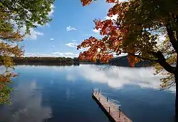 A typical lake scene in Muskoka Lakes | |
 Muskoka Lakes | |
| Coordinates: 45°07′N 79°35′W | |
| Country | |
| Province | |
| Regional Municipality | Muskoka |
| Established | 1971 |
| Government | |
| • Type | Township |
| • Mayor | Phil Harding [1] |
| • Governing Body | Muskoka Lakes Township Council |
| • MP | Scott Aitchison |
| • MPP | Norm Miller (OPC) |
| Area | |
| • Land | 794.26 km2 (306.67 sq mi) |
| Population (2016)[3] | |
| • Total | 6,588 |
| • Density | 8.3/km2 (21/sq mi) |
| Time zone | UTC-5 (EST) |
| • Summer (DST) | UTC-4 (EDT) |
| Postal code FSA | P0B |
| Area code(s) | 705 |
| Website | www.muskokalakes.ca |
The municipal offices are located in Port Carling.
History
The area now covered by the township was opened for settlement and organized in 1870 into the following geographic (and sometime municipal) townships of Watt, Cardwell, Humphrey, Christie, Medora and Wood.
In 1971, the current municipal structure took hold when Cardwell Township, Watt Township, Medora and Wood Townships, Bala, Port Carling, Windermere and part of Monck Township were merged.
Local Government
Muskoka is governed by an elected Town Council consisting of a Mayor, District Councillors and Councillors representing each of the town's three wards. In addition, three Regional Councillors each represent a ward each. The Mayor and Councillors sit on the Muskoka County Council.
The members of the elected council as of the 2018 municipal election are:[4]
Mayor: Phil Harding
District & Township Councillors:
- Ward 1: Ruth-Ellen Nishikawa
- Ward 2: Allen Edwards
- Ward 3: Frank Jaglowitz
Township Councillors:
- Ward 1: Donelda Hayes
- Ward 1: Glenn Zavitz
- Ward 2: Susan Mazan
- Ward 2: Gordon Roberts
- Ward 3: Barb Bridgeman
- Ward 3: Peter Kelley
Geography
The township is located on Canadian Shield and thus is marked with outcrops of igneous rock and evergreen trees. Although inland from both Lake Huron's Georgian Bay and Lake Simcoe, the township contains the Muskoka Lakes consisting of Lake Muskoka, Lake Rosseau and Lake Joseph, amongst many other smaller lakes.
Protected areas in Muskoka Lakes include Hardy Lake Provincial Park and Torrance Barrens Conservation Area.
Communities
The township contains the communities of Bala, Bala Park, Bardsville, Barlochan, Beaumaris, Baysville, Bear Cave, Beatrice, Bent River, Brackenrig, Cedar Village, Dee Bank, Dixon's Corners, Dudley, Duffy, Echo Beach, Ferndale, Foot's Bay, Glen Orchard, Gregory, Gull Rock, Hekkla, Inverness Lodge, Juddhaven, Mendora, Milford Bay, Minett, Morinus, Mortimers Point, Park Beach, Port Carling, Port Keewaydin, Port Sandfield, Raymond, Redwood, Roderick, Rossclair, Rosseau Falls, Rostrevor, Shannon Hall, Sunset Beach, Thorel House, Tomelin Bluffs, Torrance, Ufford, Ullswater, Valley Green Beach, Walkers Point, Willow Beach, Whiteside, Windermere, Woodington, Woodward Station and Ziska.
Climate
| Climate data for Beatrice (1981−2010) | |||||||||||||
|---|---|---|---|---|---|---|---|---|---|---|---|---|---|
| Month | Jan | Feb | Mar | Apr | May | Jun | Jul | Aug | Sep | Oct | Nov | Dec | Year |
| Record high °C (°F) | 11.0 (51.8) |
12.5 (54.5) |
21.0 (69.8) |
31.0 (87.8) |
32.0 (89.6) |
33.0 (91.4) |
33.0 (91.4) |
32.5 (90.5) |
31.5 (88.7) |
27.0 (80.6) |
19.0 (66.2) |
16.5 (61.7) |
33.0 (91.4) |
| Average high °C (°F) | −5.0 (23.0) |
−2.5 (27.5) |
2.4 (36.3) |
10.7 (51.3) |
18.1 (64.6) |
22.6 (72.7) |
24.9 (76.8) |
23.8 (74.8) |
19.3 (66.7) |
12.1 (53.8) |
4.7 (40.5) |
−1.5 (29.3) |
10.8 (51.4) |
| Daily mean °C (°F) | −10.7 (12.7) |
−8.7 (16.3) |
−3.8 (25.2) |
4.4 (39.9) |
11.0 (51.8) |
15.8 (60.4) |
18.2 (64.8) |
17.3 (63.1) |
13.1 (55.6) |
6.8 (44.2) |
0.4 (32.7) |
−6.4 (20.5) |
4.8 (40.6) |
| Average low °C (°F) | −16.3 (2.7) |
−14.9 (5.2) |
−10.1 (13.8) |
−2.0 (28.4) |
3.9 (39.0) |
8.9 (48.0) |
11.4 (52.5) |
10.7 (51.3) |
6.8 (44.2) |
1.3 (34.3) |
−3.9 (25.0) |
−11.2 (11.8) |
−1.3 (29.7) |
| Record low °C (°F) | −42.5 (−44.5) |
−38.0 (−36.4) |
−36.0 (−32.8) |
−21.0 (−5.8) |
−8.5 (16.7) |
−4.0 (24.8) |
−0.5 (31.1) |
−3.5 (25.7) |
−7.0 (19.4) |
−11.0 (12.2) |
−26.0 (−14.8) |
−41.5 (−42.7) |
−42.5 (−44.5) |
| Average precipitation mm (inches) | 114.6 (4.51) |
82.5 (3.25) |
75.2 (2.96) |
76.8 (3.02) |
97.9 (3.85) |
87.7 (3.45) |
94.3 (3.71) |
87.7 (3.45) |
113.6 (4.47) |
118.4 (4.66) |
124.0 (4.88) |
125.0 (4.92) |
1,197.7 (47.15) |
| Average rainfall mm (inches) | 28.3 (1.11) |
22.9 (0.90) |
39.6 (1.56) |
66.4 (2.61) |
97.7 (3.85) |
87.7 (3.45) |
94.3 (3.71) |
87.7 (3.45) |
113.6 (4.47) |
114.1 (4.49) |
87.3 (3.44) |
37.0 (1.46) |
876.7 (34.52) |
| Average snowfall cm (inches) | 86.4 (34.0) |
59.6 (23.5) |
35.6 (14.0) |
10.4 (4.1) |
0.2 (0.1) |
0.0 (0.0) |
0.0 (0.0) |
0.0 (0.0) |
0.0 (0.0) |
4.3 (1.7) |
36.6 (14.4) |
88.0 (34.6) |
321.1 (126.4) |
| Average precipitation days (≥ 0.2 mm) | 17.4 | 13.5 | 12.0 | 12.4 | 13.8 | 13.3 | 11.9 | 12.9 | 14.4 | 17.0 | 16.8 | 17.3 | 172.6 |
| Average rainy days (≥ 0.2 mm) | 3.6 | 3.4 | 5.9 | 10.7 | 13.8 | 13.3 | 11.9 | 12.9 | 14.4 | 16.4 | 11.9 | 5.4 | 123.4 |
| Average snowy days (≥ 0.2 cm) | 15.2 | 11.3 | 7.4 | 2.7 | 0.08 | 0.0 | 0.0 | 0.0 | 0.0 | 1.3 | 5.9 | 13.4 | 57.2 |
| Source: Environment Canada[5] | |||||||||||||
Demographics
| Canada census – Muskoka Lakes community profile | |||
|---|---|---|---|
| 2016 | 2011 | 2006 | |
| Population: | 6588[3] (-1.8% from 2011) | 6707 (3.7% from 2006) | 6467 (7.0% from 2001) |
| Land area: | 794.26 km2 (306.67 sq mi) | 794.48 km2 (306.75 sq mi) | 781.55 km2 (301.76 sq mi) |
| Population density: | 8.3/km2 (21/sq mi) | 8.4/km2 (22/sq mi) | 8.3/km2 (21/sq mi) |
| Median age: | 54.7 (M: 54.3, F: 5.2) | 47.4 (M: 47.1, F: 47.6) | |
| Total private dwellings: | 9343 | 9723 | 9211 |
| Median household income: | $55,835 | ||
| References: 2016[6] 2011[7] 2006[8] earlier[9] | |||
Racial groups
Religious groups
- 58.8% Protestant
- 17.4% Roman Catholic
- 2.0% other Christian
- 21.8% non-religion
Economy
Timber was initially the greatest economic attraction for the region. The soil is poor and rocky and consequently is not especially suited to agriculture.
As the resource industries dried up, the area soon embraced tourism as its economic base because of its proximity to Toronto and the rest of Southern Ontario. For many Ontarians, this is the centre of cottage country.
The Muskoka Lakes Township Public Libraries offers research, literature, and cultural resources to local residents. The libraries consist of the Norma and Miller Alloway Muskoka Lakes Library main branch in the town of Port Carling, and three small branches housed in the community centres of Bala, Milford Bay, and Walker's Point.
Notable people from Muskoka
- James Bartleman, politician and diplomat
- Viola R. MacMillan, prospector and miner
See also
References
- "Certificate of Election Results". Township of Muskoka Lakes. Retrieved 2018-12-05.
- "Muskoka Lakes census profile". 2011 Census of Population. Statistics Canada. Retrieved 2012-03-07.
- "2016 Canadian Census". Statistics Canada. 2016. Retrieved February 26, 2018.
- "Certificate of Election Results". muskokalakes.civicweb.net. October 22, 2018. Retrieved December 5, 2018.
- "Beatrice 2, Ontario". Canadian Climate Normals 1981–2010. Environment Canada. Archived from the original on July 25, 2019. Retrieved July 25, 2019.
- "2016 Community Profiles". 2016 Canadian Census. Statistics Canada. February 21, 2017. Retrieved 2019-02-26.
- "2011 Community Profiles". 2011 Canadian Census. Statistics Canada. July 5, 2013. Retrieved 2012-03-07.
- "2006 Community Profiles". 2006 Canadian Census. Statistics Canada. March 30, 2011. Retrieved 2012-03-07.
- "2001 Community Profiles". 2001 Canadian Census. Statistics Canada. February 17, 2012.
- Tatley, Richard. Steamboating in Muskoka. Bracebridge, Ontario : Muskoka Litho, 1972.
External links
| Wikimedia Commons has media related to Muskoka Lakes, Ontario. |
Places adjacent to Muskoka Lakes | |
|---|---|