The Archipelago
The Archipelago is a township in central Ontario, Canada, along the Georgian Bay in the District of Parry Sound.
The Archipelago | |
|---|---|
| Township of The Archipelago | |
 | |
 The Archipelago | |
| Coordinates: 45°35′N 80°23′W | |
| Country | Canada |
| Province | Ontario |
| District | Parry Sound |
| Incorporated | 1980 |
| Government | |
| • Type | Township |
| • Reeve | Bert Liverance |
| • Federal riding | Parry Sound—Muskoka |
| • Prov. riding | Parry Sound—Muskoka |
| Area | |
| • Land | 606.14 km2 (234.03 sq mi) |
| Population (2016)[2] | |
| • Total | 531 |
| • Density | 0.9/km2 (2/sq mi) |
| Time zone | UTC-5 (EST) |
| • Summer (DST) | UTC-4 (EDT) |
| Area code(s) | 705 |
| Website | www.thearchipelago.on.ca |
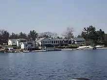
The municipality consists of two non-contiguous parts, separated by Carling Township and the Parry Sound. The northern part includes the village of Pointe au Baril on the mainland and most of the geographic townships of Shawanaga and Harrison. This covers the islands and shoreline of Georgian Bay from the Twin Sisters (at the northern boundary of Carling Township) north to Charles Inlet and the Naiscoot River, a few miles south of Britt. The southern part consists of the geographic townships of Cowper and Conger that includes the islands and shoreline of Georgian Bay southwest of Parry Sound, from Twelve Mile Bay (at the Muskoka District boundary) to Parry Island and up the South Channel almost to the Town of Parry Sound. Almost a third of the population of the southern part lives on the islands in the Sans Souci and Copperhead area, centred on Frying Pan Island.[3]
The township is characterized by numerous islands (hence its name) and bays that attract large numbers of vacationers and boaters in the summer. Much of its area is undeveloped and crown-owned land: in the north, 96 percent of the mainland and 50 percent of the islands remain in the public domain, and in the south, 83 percent of the mainland and 70 percent of the islands, a large part of it protected in The Massasauga Provincial Park.[3]
Communities
- Bayfield Inlet
- Blackstone Lake
- Copperhead
- Five Mile Bay
- Georgian Inlet
- Manbert
- Manitou Dock
- Naiscoot
- Nares Inlet
- Niweme
- Ojibway Island
- Pointe au Baril
- Pointe au Baril Station
- Sans Souci
- Seven Mile Narrows
- Skerryvore
- Woods Bay
History
On January 1, 1980, the townships of Georgian Bay South Archipelago and Georgian Bay North Archipelago were formed out of unincorporated geographic townships from the Parry Sound District, primarily in order to provide proper planning in the islands and waterways of the area. These two townships were intended to be set up as one municipality but the Ontario Legislature created two townships, with a provision for their later amalgamation, if requested by the elected Councils. Soon after the formation of the townships, both councils passed identical by-laws calling for the amalgamation of the two municipalities. Therefore, the Township of the Archipelago was formed on April 1, 1980, when the townships of Georgian Bay South Archipelago and Georgian Bay North Archipelago merged.[3]
Demographics
| Year | Pop. | ±% |
|---|---|---|
| 1991 | 720 | — |
| 1996 | 555 | −22.9% |
| 2001 | 505 | −9.0% |
| 2006 | 576 | +14.1% |
| 2011 | 566 | −1.7% |
| 2016 | 531 | −6.2% |
| [4][1][2] | ||
| Canada census – The Archipelago community profile | |||
|---|---|---|---|
| 2016 | 2011 | ||
| Population: | 531 (-6.2% from 2011) | 566 (-1.7% from 2006) | |
| Land area: | 606.14 km2 (234.03 sq mi) | 606.56 km2 (234.19 sq mi) | |
| Population density: | 0.9/km2 (2.3/sq mi) | 0.9/km2 (2.3/sq mi) | |
| Median age: | 58.5 (M: 58.4, F: 58.6) | ||
| Total private dwellings: | 2,693 | 3,008 | |
| Median household income: | $67,712 | ||
| References: 2016[5] 2011[6] earlier[7] | |||
- Mother tongue:[8]
- English as first language: 90.4%
- French as first language: 0%
- English and French as first language: 0%
- Other as first language: 8.6%
Education
The community is within the Near North District School Board.
As of 1975, Moon Island, within The Archipelago, was served by the Sugar Bay School. That year, it was one of 21 one-room schools in the province. That year there were 12 students in grades 1-8 with ages ranging from 6 to 13. At the time the closest high school to Moon Island was in Parry Sound, 19 miles (31 km) away from Moon Island. Moon Island residents who attended high school lived with relatives living in Parry Sound or stayed at boarding houses during the school year.[9]
References
- 2011 Census Profile
- "Census Profile, 2016 Census: The Archipelago, Township". Statistics Canada. Retrieved March 8, 2019.
- "Township History". Township of The Archipelago. Retrieved March 8, 2019.
- Statistics Canada: 1996, 2001, 2006
- "2016 Community Profiles". 2016 Canadian Census. Statistics Canada. February 21, 2017. Retrieved 2019-06-28.
- "2011 Community Profiles". 2011 Canadian Census. Statistics Canada. July 5, 2013.
- "2001 Community Profiles". 2001 Canadian Census. Statistics Canada. February 17, 2012.
- "2006 Community Profile".
- "One room school on an island." The Canadian Press at The Montreal Gazette. Friday December 5, 1975. p. 41. Retrieved from Google News (41 of 172) on October 2, 2013.
- "Topographic Map sheets 31E4, 31E5, 41H1, 41H8, 41H9, 41H10". Atlas of Canada. Natural Resources Canada. 2006-02-06. Retrieved 2009-06-13.
- "The Archipelago". 2006 Community Profiles. Statistics Canada. 2009-03-10. Retrieved 2009-06-13.
External links
- North part
Places adjacent to The Archipelago | ||||||||||
|---|---|---|---|---|---|---|---|---|---|---|
| ||||||||||
- South part
Places adjacent to The Archipelago | ||||||||||
|---|---|---|---|---|---|---|---|---|---|---|
| ||||||||||
| Towns | 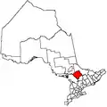 | |
|---|---|---|
| Townships | ||
| Villages | ||
| First Nations | ||
| Indian reserves | ||
| Local services boards | ||
| Unorganized areas | ||
| ||