National Register of Historic Places listings in Guadalupe County, Texas
This is a list of the National Register of Historic Places listings in Guadalupe County, Texas.
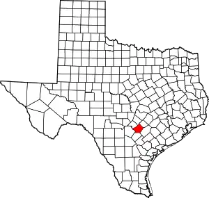
This is intended to be a complete list of properties and districts listed on the National Register of Historic Places in Guadalupe County, Texas. There are two districts and 12 individual properties listed on the National Register in the county. Two individually listed properties are State Antiquities Landmarks including one along with five other properties that are designated Recorded Texas Historic Landmarks. One district includes an additional Recorded Texas Historic Landmark.
- This National Park Service list is complete through NPS recent listings posted January 29, 2021.[1]
Current listings
The publicly disclosed locations of National Register properties and districts may be seen in a mapping service provided.[2]
| [3] | Name on the Register[4] | Image | Date listed[5] | Location | City or town | Description |
|---|---|---|---|---|---|---|
| 1 | Dublin Plantation | .tif.jpg.webp) Dublin Plantation |
December 11, 2013 (#13000918) |
3135 Cottonwood Creek Road 29°42′15″N 97°46′58″W |
Kingsbury vicinity | Recorded Texas Historic Landmark |
| 2 | Erskine House No. 1 |  Erskine House No. 1 |
August 25, 1970 (#70000750) |
902 N. Austin St. 29°34′01″N 97°57′51″W |
Seguin | Recorded Texas Historic Landmark |
| 3 | Robert Hall House | 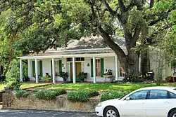 Robert Hall House |
October 25, 1979 (#79002949) |
214 S. Travis St. 29°34′03″N 97°58′00″W |
Seguin | |
| 4 | Hardscramble | July 6, 2011 (#11000424) |
1806 Tschoepe Rd. 29°38′04″N 97°52′52″W |
Seguin vicinity | ||
| 5 | Joseph F. Johnson House | Joseph F. Johnson House |
June 23, 1978 (#78002940) |
761 Johnson Ave. 29°33′49″N 97°58′26″W |
Seguin | |
| 6 | King-Woods Farmstead |  King-Woods Farmstead |
April 2, 2018 (#100002268) |
920 E Court St. 29°34′10″N 97°57′15″W |
Seguin | |
| 7 | Los Nogales | 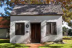 Los Nogales |
March 24, 1972 (#72001365) |
S. River and E. Live Oak Sts. 29°33′57″N 97°57′47″W |
Seguin | Recorded Texas Historic Landmark |
| 8 | Park Hotel |  Park Hotel |
May 23, 1980 (#80004124) |
217 S. River St. 29°34′02″N 97°57′49″W |
Seguin | |
| 9 | Saffold Dam |  Saffold Dam |
November 15, 1979 (#79002950) |
Off TX 123 29°33′03″N 97°58′12″W |
Seguin | State Antiquities Landmark |
| 10 | Sebastopol | 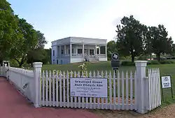 Sebastopol |
August 25, 1970 (#70000751) |
NE corner of W. Court and N. Erkel Sts. 29°34′12″N 97°58′21″W |
Seguin | State Antiquities Landmark, Recorded Texas Historic Landmark |
| 11 | Seguin Commercial Historic District |  Seguin Commercial Historic District |
December 15, 1983 (#83003773) August 14, 2013 boundary increase (#03000768) |
Roughly bounded by Camp, Myrtle, Washington, and Crockett Sts. 29°34′13″N 97°57′51″W |
Seguin | Includes Recorded Texas Historic Landmark; 70 buildings, 1 structure, 1875-1949; boundary increase in 2013 added 9 buildings. |
| 12 | State Highway 3-A Bridge at Cibolo Creek |  State Highway 3-A Bridge at Cibolo Creek |
October 10, 1996 (#96001112) |
I-10 at the Bexar and Guadalupe Cnty. line 29°30′05″N 98°11′11″W |
Schertz | Extends into Bexar County |
| 13 | Sweet Home Vocational and Agricultural High School |  Sweet Home Vocational and Agricultural High School |
November 19, 1998 (#98001417) |
10 mi (16 km). S of Seguin on Sweet Home Rd. 29°27′40″N 98°02′21″W |
Seguin | Recorded Texas Historic Landmark |
| 14 | Edward and Texanna Tewes House |  Edward and Texanna Tewes House |
January 9, 1997 (#96001566) |
8280 Linne Rd. 29°28′03″N 98°06′11″W |
Seguin | Recorded Texas Historic Landmark |
| 15 | Wilson Utility Pottery Kilns Archeological District |  Wilson Utility Pottery Kilns Archeological District |
April 16, 1975 (#75001987) |
Address restricted[6] |
Capote | Roadside historical marker located outside district |
See also
References
- "National Register of Historic Places: Weekly List Actions". National Park Service, United States Department of the Interior. Retrieved on January 29, 2021.
- The latitude and longitude information provided in this table was derived originally from the National Register Information System, which has been found to be fairly accurate for about 99% of listings. Some locations in this table may have been corrected to current GPS standards.
- Numbers represent an alphabetical ordering by significant words. Various colorings, defined here, differentiate National Historic Landmarks and historic districts from other NRHP buildings, structures, sites or objects.
- "National Register Information System". National Register of Historic Places. National Park Service. July 9, 2010.
- The eight-digit number below each date is the number assigned to each location in the National Register Information System database, which can be viewed by clicking the number.
- Federal and state laws and practices restrict general public access to information regarding the specific location of this resource. In some cases, this is to protect archeological sites from vandalism, while in other cases it is restricted at the request of the owner. See: Knoerl, John; Miller, Diane; Shrimpton, Rebecca H. (1990), Guidelines for Restricting Information about Historic and Prehistoric Resources, National Register Bulletin, National Park Service, U.S. Department of the Interior, OCLC 20706997.
External links
![]() Media related to National Register of Historic Places in Guadalupe County, Texas at Wikimedia Commons
Media related to National Register of Historic Places in Guadalupe County, Texas at Wikimedia Commons

