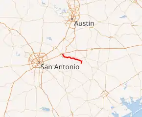
Leesville, Texas
Leesville is an unincorporated city of 384 residents distributed over 51 square miles in the Gonzales—Guadalupe County, Texas area (USA) alongside ![]()
![]() SH 80 / FM 1682, electorally known as local Precinct 13;[22] defined by the south of its Capote Hills ("El Capote Ranch")[23] at
SH 80 / FM 1682, electorally known as local Precinct 13;[22] defined by the south of its Capote Hills ("El Capote Ranch")[23] at ![]()
![]() FM 466 / SH 80, and the north of Sandies Creek between
FM 466 / SH 80, and the north of Sandies Creek between ![]()
![]()
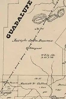
![]() FM 1117 / SH 80 / SH 97. Beginning in the 19th-century, the municipal identity of Leesville was founded upon being one of the first Justice of the Peace Precincts[13] of its original county-area, as prescribed in the Texas Constitution; as well as once generally serving as the primary seat of a former Texas House District 90, once rated at more than 1,000 constituents.[14][15] Straddling and nearing the southeastern border of Guadalupe County, the real estate origins of Leesville go back to the 1800s survey-plots[3][2] of Texas Revolution figures Ezekiel Wimberly Cullen[24] (late owner of Sandies Creek) and Count Joseph de la Baume of France (late owner of Capote Hills); the latter retaining Texas's founding father Stephen F. Austin as an attorney, to reacquire the early-1800s Spanish land-tract, after Mexico's Independence from Spain in 1825.[25] Divided by
FM 1117 / SH 80 / SH 97. Beginning in the 19th-century, the municipal identity of Leesville was founded upon being one of the first Justice of the Peace Precincts[13] of its original county-area, as prescribed in the Texas Constitution; as well as once generally serving as the primary seat of a former Texas House District 90, once rated at more than 1,000 constituents.[14][15] Straddling and nearing the southeastern border of Guadalupe County, the real estate origins of Leesville go back to the 1800s survey-plots[3][2] of Texas Revolution figures Ezekiel Wimberly Cullen[24] (late owner of Sandies Creek) and Count Joseph de la Baume of France (late owner of Capote Hills); the latter retaining Texas's founding father Stephen F. Austin as an attorney, to reacquire the early-1800s Spanish land-tract, after Mexico's Independence from Spain in 1825.[25] Divided by ![]() FM 1682 joining with Gonzales—Guadalupe County Road 121 West, Leesville's northern territory is closest to the Austin Metropolitan Areas through
FM 1682 joining with Gonzales—Guadalupe County Road 121 West, Leesville's northern territory is closest to the Austin Metropolitan Areas through ![]()
![]() SH 80 / US 183, while the southern territory is closest to the San Antonio Metropolitan Areas through
SH 80 / US 183, while the southern territory is closest to the San Antonio Metropolitan Areas through ![]()
![]() SH 97 / US 87.
SH 97 / US 87.
Leesville | |
|---|---|
 Leesville, Texas State Highway 80 | |
| Nickname(s): | |
| Motto(s): Come and Grind It; Staying Happy | |
| |
| Coordinates: 29°24′25″N 97°44′42″W | |
| Tracts | Sandies—E.W. Cullen League; Capote—De la Baume Leagues (6)[3] |
| Jurisdiction | 25th Texas District Court, Guadalupe Courthouse[5] |
| Subregion | East Central Texas |
| Region | Texas Triangle |
| Granted | 1806 (de la Baume)[6][7] |
| Settled | ca. 1830s-1861 (pre-Civil War) |
| Founded | 1874[8][9] |
| Recognized | ca. 1891 (state law)[10] |
| Founded by | Newburn H. Guinn, Developer; Changed from Leesburg to Leesville by U.S. Postal Service |
| Named for | Lee Guinn, daughter of founder[11][12] |
| Precinct | Electoral Precinct 13 |
| Former Seats | Late-1800s: Texas House District 90; "Leesville Precinct," Justice of the Peace |
| Government | |
| • Type | De facto; 19th-century Court of law, |
| • Body | Historical, event associations with the Leesville name; Special municipally owned corporation |
| • Patron | Leesville Country Fair |
| • Elections | Leesville Cemetery Association |
| • Trade | Leesville Farmers' Union † |
| • Water | Schertz-Seguin Local Government Corp. |
| • Officials | Historical elections
|
| Area | |
| • Total | 32,793 acres (13,271 ha) |
| • Water | .12 sq mi (0.3 km2) |
| Elevation | 520 ft (160 m) |
| Highest elevation (Capote's Knob) | 670 ft (200 m) |
| Population | |
| • Total | 384 |
| • Density | 7.5/sq mi (2.9/km2) |
| • Traffic | 12,179 vehicles (AADT) |
| • Traffic density | 238.8/sq mi (92.2/km2) |
| • West Capote | 1,647 (rural Guadalupe County) |
| Time zone | UTC−06:00 (CST) |
| • Summer (DST) | UTC−05:00 (CDT) |
| ZIP code | |
| Location | SE Guadalupe County line; West Gonzales County; South of Belmont; North of Nixon; West of Bebe |
| Expressway | |
| U.S. Route | |
| Proximate rail | San Marcos Station |
| Proximate primary airport | Austin–Bergstrom International Airport |
| Website | U.S. Post Office, Leesville |
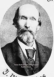
In 1844, De la Baume's heirs sold out to Michael Erskine, a then-future Confederate Army commander of the Sandies Creek, Leesville area; the namesake of Leesville's founder "N. Guinn" serving under this "Sandies Home Guard" as a Third Lieutenant in 1861. Erskine held the land until 1882 when it was purchased by a group of speculative investors, including Mrs. Theodore Roosevelt. The lien on the property was held by the Scottish-American Mortgage Company, Ltd., financiers of the well-known Swan Land and Cattle Co. and Prairie Land and Cattle Co.[26] The original 12-acre residential ranch-headquarters in the "Alameda" of Downtown San Antonio, formerly known as "La Baume Place" upon the St. Joseph Catholic Church, has since been relinquished and divested from the property. From this time period into present-day, just before and after Judge Leroy G. Denman took ownership, the complexities of this large estate and its jurisdiction have led to direct interventions by late San Antonio mayor John W. Smith; and the Texas Courts of Appeals (its caselaw cited in ConocoPhillips Co. v. Ramirez), through the trust of Trinity University and the San Antonio Museum of Art.[27][28][26]
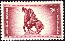
As the 19th-century concluded, its expatriate George W. Littlefield acted as a significant Texan architectural patron and proprietor of the Driskill Hotel, the Littlefield House and the Littlefield Building[29] in Austin, Texas; he relocated to what is now Downtown Austin after three of his family members died in a gunfight in 1880s Leesville.[30][31] During the Spanish–American War, Theodore Roosevelt rode a Capote, Leesville area horse, "Seguin", at the Battle of San Juan Hill (1898). Several other horses from the area were used by the 1st United States Volunteer Cavalry ("Roosevelt's Rough Riders") as well.[6] During this time, Frederick Law Olmsted, then-future designer of New York City’s Central Park, made the area’s principal species of trees and agriculture as a point of his studies.[32]
Through the early 20th-century, rail transport and interurban rail were proposed and built intermittently, including a 1916 Houston—San Antonio electric railway concept and proposal, with Leesville as a main line station. Towards the late 20th-century, the ventures either remained undeveloped or developed then terminated with the rail easements sold to the Lower Colorado River Authority, as an overhead power line. At present, the primary industries of the Capote-Sandies, Leesville area are under the real estate holdings of vast Texas Wildlife Management Areas, and the primary Quien Sabe Ranch that raises Santa Gertrudis cattle of King Ranch Running W Bull descent. The most valuable asset in this area is a $149-million water facility and 40-mile pipeline, that can store and move up to 11.6 million gallons of water towards the Greater San Antonio areas. According to the Texas Department of Transportation, 12,179 vehicles travel through the Leesville-area daily, with the busiest intersection rated at 2,978 vehicles; thru-traffic utilizes Leesville routes to generally bypass ![]() SH 123 upon Wilson County—Seguin.
SH 123 upon Wilson County—Seguin.
Services
In 2000, Leesville had 7 businesses.[33] It is situated at the southwestern Gonzales—Guadalupe County line, approximately 19 miles south of ![]() US 183 North in Luling (Greater Austin) and 26 miles west of
US 183 North in Luling (Greater Austin) and 26 miles west of ![]() US 183 South in Gonzales.[34]
The historical city center of Leesville is located alongside the street of
US 183 South in Gonzales.[34]
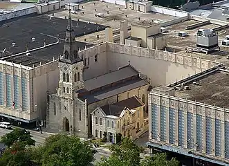
The historical city center of Leesville is located alongside the street of ![]() FM 1682, where the city’s original church and cemetery reside; currently acting as a location for local events.[35][36][37]
FM 1682, where the city’s original church and cemetery reside; currently acting as a location for local events.[35][36][37]
Leesville is within 59 miles of the city centers of these significant, medium-to-large cities; respectively: Seguin, New Braunfels, Schertz, Lockhart, Universal City, San Marcos, Converse, Live Oak, Kirby, Kyle, Canyon Lake, San Antonio, Leon Valley, Pleasanton and Austin.[38]
Economy
In 2016, Leesville business owners earned, in total, an estimated $1.3 million.[39] Through 1999–2018, the aggregate household income for the city ranged from $7.8-$10.6 million annually.[40][41]
All commercial and residential properties in Leesville paid a combined estimate of $192,500 in property taxes in 2016.[42]
In 2019 as rated by the Texas Department of Transportation, the aggregate annual-average-daily-traffic (AADT) of all local state highway-segments, that intersected into the Capote-Sandies, Leesville area, was rated at 12,179 vehicles. The Midtown-Downtown ![]()
![]() SH 80 / FM 1682 intersection was rated at 2,978 vehicles.[43]
SH 80 / FM 1682 intersection was rated at 2,978 vehicles.[43]
Real estate
As of 2018, Leesville was rated as having 249 residential structures[44] with a total of 1,253 rooms;[45] 825 of these were rated as owner-occupied, 184 were rated as renter-occupied.[46] The vast majority of these renters are not charged "cash rent;" the 9 cash renters in Leesville pay from $150-$199 per month.[47] Within Gonzales County, generally any subdivision or "improvement" of land less than 10 acres must be directly approved by the County Commission;[48] approximately zero residential structures have been approved and built in Leesville, Gonzales County after 2014, as recorded by the census in 2017.[49]
The local median cost of housing, as of 2016–2018, ranges from $546 to $633 per month;[50][51] with the households of the city paying an aggregate $23,500 in annual property taxes.[52] In estimation, of local workers 16 years and over who do not work at home, 16% commute within 5 minutes of their place of work; 28% commute within 15 to 24 minutes; 56% commute half an hour or more.[53]
An estimated majority of homes (40.5%) in the area were built from 1980 to 1999.[54] The estimated median year Leesville homes were moved into was 1996.[55]
Through 2000–2018, all occupied residential real estate in Leesville was valued from 13.9 to 19.6-million dollars,[56][57] leading to a residential value density of more than $400.00 per acre, of 32-thousand acres of Leesville land. As of 2020, vacant Leesville land not yet developed, sold at $4,649 per acre; based on recent volume-land sales data of more than 200 acres;[58] within the same time period, an additional sample of volume-land sales data of more than 300 acres, indicates $4,995 per acre.[59]
Overall, historical pricing includes 26,568 acres of the late Joseph de la Baume's "El Capote Ranch," the majority of Leesville's land; appraised and inventoried in 1862: The Guadalupe County side priced at $28,780.00, while the Gonzales County side priced at $9,965.00. In 1872, 17,623 acres of El Capote in Gonzales—Guadalupe County was priced at $35,246.00.[6][60][61][62] This 19th-century data indicates original pricing at or less than $2 per acre, not adjusting for inflation.
Civic
Leesville has a post office with the zip code of 78122.[63] The U.S. Postal Service offered to close the Leesville Post Office in 2011.[64] Under postal code 78122, the Leesville post office serves relevant areas from ![]() FM 466 (Capote Road) to
FM 466 (Capote Road) to ![]() SH 97; with the UPS and FedEx parcel services offering doorstep service to every residential address.
SH 97; with the UPS and FedEx parcel services offering doorstep service to every residential address.
Public education in the areas of Leesville are provided by Gonzales Independent School District, Nixon-Smiley Consolidated Independent School District and Seguin Independent School District.[65][66] Since 1998, an organization known as the Happy Quilters has produced quilts for auction at the annual Leesville Country Fair, to maintain Leesville landmarks such as the Leesville school house; while supporting local education, by raising $1,000 or more in support per quilt.[67][68]
Leesville relays issues of improper garbage disposal to state and county authorities.[69]
An extreme-western portion of Capote, Leesville in Guadalupe County attempted to incorporate as the “City of Capote Hills,” with 16.77% of qualifying voters voting “For” and 83.23% voting “Against” in 2017. Most “blank voted” regarding proposed city council and mayor seats.[70] The rural population near this outlying area, just west of Capote, approaches 1,647 people; as the region maps west with the more developed Guadalupe County.[19]
Water
Upon Sandies Creek, Leesville, the Schertz-Seguin Local Government Corporation transports water from the local Carrizo Aquifer utilizing a 40-mile pipeline. This project was arranged in 2012 at a reported cost of $149-million. In 2014, this facility was permitted to pump 19,363 acre-feet of water per year, with a then-present utilization of 10,000 acre-feet. Over 60,000 households can be sustained through this water supply.[71]
The location of the SSLGC water supply upon Leesville, between Gonzales and Guadalupe Counties, was a strategic choice to mitigate cost and provide long-term reliability of the water source for nearby cities. As of 2016, the system can store up to 11.6 million gallons of water.[72]
Fitch Ratings remarked on this water company's inability to directly assign liabilities to either the City of Schertz or Seguin. It has also remarked that COVID-19 has not affected the demand of water from the facility. As of 2020 through 2016, the facility makes over $9.2-million in revenue each year and serves additional cities such as Selma and Universal City.[73]
County
Gonzales County is a county in the U.S. state of Texas. As of the 2010 census, its population was 19,807.[74] The county is named for its county seat, the city of Gonzales.[75] The county was created in 1836 and organized the following year.[76][77] As of August 2020, under strict budgetary limitations, the County of Gonzales government-body is unique in that it claims to have no commercial paper, regarding it as "the absence of any county debt."[78]
According to the census, all areas county-wide had $188,099,000 in total annual payroll (2016), $550,118,900 (±39,442,212; 2018) in aggregate annual income, and $238,574,000 in total annual retail sales (2012). In 2018, the census valued all real estate in the county at an aggregate $795,242,300 (±74,643,103); with an aggregate $29,058,000 of real estate being listed for sale and $173,100 listed for rent. In the same year, approximately, the top 5% of households made an average of $361,318; the top 20% averaged at $188,699; the fourth quintile at $79,601; the third quintile (median income) at $53,317; the second quintile at $31,238; and the lowest at $13,339.[79] The Texas Almanac rated all categories of land in the county at an aggregate value of $5.6-billion.[80]Agriculture
- Belmont Wildlife Management Association[81]
- Leesville 4-H Club[82]
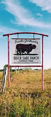
- Quien Sabe Ranch (Pioneer Santa Gertrudis Breeder);[83][84] as late as 1954, this ranch has utilized a foundation stock of cattle from the herds of Richard King and a “John Martin,” claiming all to be from King Ranch Running W Bull lineage[85]
- Sandies Creek Wildlife Management Association[86]
Transportation
| |
|---|---|
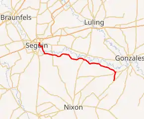
| |
| Route information | |
| Length | 34.392 mi (55.349 km) |
| Existed | July 9, 1945–present |
| Major junctions | |
| West end | |
| East end | |
| Location | |
| Counties | Guadalupe, Gonzales County |
| Highway system | |
| ||||
|---|---|---|---|---|
| Leesville SH 80 | ||||
| Route information | ||||
| Maintained by TxDOT | ||||
| Length | 19.6 mi (31.5 km) | |||
| Existed | 1932–present | |||
| Major junctions | ||||
| North end | ||||
| South end | ||||
| Location | ||||
| Counties | SE Guadalupe County line, Gonzales County | |||
| Highway system | ||||
| ||||
 SH 80 (TxDOT), corridor to


 I-10 / US 183 / SH 130 / I-35
 SH 97 (TxDOT), corridor to
  I-37 / US 183 / I-10
 FM 466, Leesville-Belmont (TxDOT), Belmont-bridge bypass at
 FM 1117 / FM 2438 / SH 130;
- Eastern bypass at County Road 143, Monthalia
- FM 1117, Leesville-Dewville (TxDOT), Gonzales County bypass towards Seguin (County Road 121/114 access)
Intercity
Neighborhoods
- County Road 159 West (78122-4209), West Midtown access-road
- County Road 102, West Uptown; Quien Sabe Ranch[83]
- East County Road 104 (78122-4238), Northeast O'Neill Creek – Baker Branch
- West County Road 104 (78122-4272), East Fork O'Neill Creek
- East County Road 109, East Uptown access-road
- County Road 155, Downtown loop and bypass
- County Road 159 East (78122-4273), East Midtown access-road
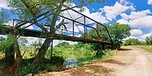
- Sandies Creek Bridge – SH 80, 8000-block (78122-428X)
- County Road 114 / 157 / 113, Sandies Creek embankments
- County Road 121, west end divide
Airports
- Austin-Bergstrom International Airport (58 highway-miles)
- San Antonio International Airport (70 highway-miles)
- Corpus Christi International Airport (144 highway-miles)
- George Bush Intercontinental Airport (174 highway-miles)
- William P. Hobby Airport (176 highway-miles)
History
| Year | Pop. | ±% |
|---|---|---|
| 1860* | 70 | — |
| 1880* | 1,000 | +1328.6% |
| 1900* | 708 | −29.2% |
| 2000 | 201 | −71.6% |
| 2010 | 418 | +108.0% |
| 2018** | 384 | −8.1% |
| Census/Voting Records[88][14][15] Military Records[89][90] *≥ **Estimated | ||
Early population
Within a limited historical record of the Leesville population, a 1904 voting press-record from The Houston Post indicates at least 708 ballots were cast in Leesville during a primary election.[91] In the 1880s, during the Texas House of Representatives election of what was considered a Leesville district, vote counts were measured in the thousands.[14][15]
One of the earliest forms of social establishment and organization in the Leesville area, or interchangeably Leesburg at the time, involved common-property of "the people of Leesburg" most-especially a single crowbar; quoted as being shared contiguously by the community from 1863 until as late as 1883, when it was thought to have been used in a local theft of the Peebles & Brown store.[92]
Name

The first settlement and commerce of the area began around Sandies Creek, said to be once landmarked by a giant granite stone; leading to the Leesville area once being referred to as Sandies. From the 1830s until the 1870s, significant amounts of social activity climaxed around this area; with theft of watermelon, corn and food occurring at a nearby property. The nearby proprietor destroyed the granite landmark in response, ending the original rapid growth of the area.[93]
The general area was then named Capote, named after its hills. In the late 1800s, local land developer Newburn H. Guinn attempted to name the town Leesburg after his daughter Lee. The local post office at the time refused to recognize the name, as another Texas town had already claimed the name Leesburg. It was then compromised that the city would be named Leesville.[8]
The greater federal government recognized Leesville, Texas as early as 1885, in patents “315,236” and “325,154;”[94] the former being an “Indicator for Merchandise”[95] and the latter being a “Marking Device.”[96]
In the 1800s, a significant portion of Leesville's southern territory was owned by Ezekiel Wimberly Cullen, with Leesville alternatively and legally known as the Ezekiel W. Cullen League (E.W. Cullen).[2][3][4]
Industry
Original businesses and organizations since the area's settlement used to include, in greater capacity:[97]
- Fayette Smith's saloon (late-1800s)[98]
- A Masonic Lodge, with $60 in silver recorded as deposited in the local bank (late-1800s);[92][14] destroyed, totaled by a fire on December 14, 1904, due to lack of insurance[99]
- Peebles & Brown mercantile storehouse and bank, with as much as $5,000 in goods and $1,400-$1,500 in currency deposits (east-side of O'Neill Creek, late-1800s)[92]
- Sylvester A. Hubbard‘s ox-driven corn grinder and lumber saw (1860)
- Sandies Home Guard C.S.A.; Captain Michael Erskine, First Lieutenant W. H. Burris, Second Lieutenant Larkin N. West, Third Lieutenant N. W. Guinn (June 22, 1861)[89][90][100]
- Daniel Brown‘s general merchandise store (1868)
- A brick kiln (1868)
- A saddletree and stirrup factory (1868)
- Leesburg Male and Female Institute, known as “Leesville school house” (January 21, 1873)
- L.C. Cocke Pharmacy (1890s-1910s)[101][102]
- Medical doctor, Dr. M. A. McBride having moved his practice from West Point, New York to Leesville, Texas (1894)[103]
- Southern Pacific Railroad – GHSA, a "Glidden to LaGrange" ("Glidden Subdivision") spur connecting to the late "Stockdale to Cuero" branch line (constructed 1905–1907); this railway easement has been converted to an overhead power line at present-day[104][21][105]
- Hupmobile dealership, J.W. West (1913)[106]
- Leesville School System, elementary and high schools (closed in 1951)
- Lumber production
- Grain production
- Beef production
- Cotton production
- Peanut farming
- Melon farming
- Various churches including a Missionary Baptist church[14]
Rail proposals
In March 1912, the Quanah, Acme and Pacific Railway was being built 2.5 miles east of Leesville; The Houston Post indicated citizens attempted to financially cause the railroad to build near the city with a "bonus offered" at the start of its construction.[107] In the same time period, engineers of the "Quanah, Seymour, Dublin and Rockport Railroad" completed a preliminary survey for the construction of a line through Leesville.[108]
In 1916, to "J. H. Berryman & Co." served by its president Steve Holmes from Leesville; with vice-president and general manager W. A. Reinhardt from Houston: An "electric railway" contract was awarded to grade the first 60 miles out of Houston for the "Houston Richmond & Western Traction Co." A line was proposed to reach San Antonio from Houston; stopping at Richmond, Garwood, Gonzales, Steve Holmes' home of Leesville, Willow Springs and New Berlin; totaling 190 miles of proposed track.[109] The expected material cost was written as “530,000 cross-ties,” equivalent to “16,000,000 feet of lumber;” as well as “32,000 poles.” This was considered a notable “prospective order” for the lumber industry at the time.[110]
Events
In 1835, at Sandies Creek in what is now Leesville, 13 traders of Mexican and French origin traveling from Louisiana to Mexico, were killed by Comanche Native Americans.[111]
In 1889, while having lived in Leesville since 1869 with a lack of "political aspirations," over a thousand people of the Leesville general-area elected the Representative James William Peebles for the local legislative seat without Peebles direct involvement in the campaign; beating his competitor by a margin of a thousand votes. He was elected to a second-term, in the same Leesville district, from 1891.[14][15]
In 1903, the Southern Coal and Coke Company noted “a vein of coal two feet thick” in Leesville, in the coal industry journal.[112]
In 1909, there were over a dozen cases of smallpox around Leesville, spanning over months with only one case of quarantine. Traveling African-Americans were reported to be disproportionately affected.[113]
In late 2020, a porcelain sign weighing approximately 150 pounds, was stolen from Leesville’s Quien Sabe Ranch; it landmarked the northern area of Leesville at County Road 102 and ![]() SH 80. A $500 reward was circulated “for information about the theft.”[83]
SH 80. A $500 reward was circulated “for information about the theft.”[83]
Littlefield-Martin
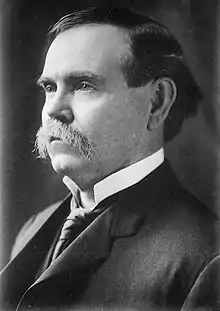
In 1880, two generations of Leesville families Littlefield[114] and Martin, received national attention after three Littlefield belligerents died in a revolver gunfight between the two families. It was postulated that the family feud would continue.[115]
The late George W. Littlefield was the grandson of one of the belligerents, through a son named Fleming Littlefield; in 1883, George Littlefield relocated to the state capital of Austin, Texas from South Texas.[116] His Littlefield Building on Congress Avenue in downtown Austin now houses Capital One Bank. From 1895 to 1903, Littlefield owned the Driskill Hotel, located near the Littlefield Building. He installed the first electric lighting system in the hotel, which became a gathering place for Texas politicians during much of the 20th century. He willed his residence, the Littlefield House, to the University of Texas.[30][31]
El Capote Ranch
The founder of El Capote Ranch was Joseph de la Baume (1731–1834), a French army officer who came to North America with the Marquis de Lafayette and fought in the American Revolution. He later joined the Spanish Army and for his services received title in 1806 to 27,000 acres of Texas land in what is now Leesville – the original El Capote Ranch. "El Capote," meaning "The Cape," was probably derived from nearby hills of the same name. De la Baume's grant was reaffirmed after Mexico won independence from Spain in 1821. Virginia-born Michael Erskine (1794–1862) acquired the property in 1840. He raised cattle here and drove his herds to California and New Orleans. Since the San Antonio to Gonzales Road forded the Guadalupe River on El Capote land, many travelers passed this way.
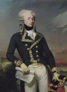
The Erskine family hosted several eminent visitors, including William Bollaert FRGS (1840), Ferdinand von Roemer (1845–1847), and Frederick Law Olmstead (1857). After the Erskine family sold the ranch in the 1870s, part of the land was deeded to Edith Kermit Carow, the second wife of Theodore Roosevelt. During the Spanish–American War, Roosevelt rode an El Capote horse, "Seguin", at the Battle of San Juan Hill (1898). Several other horses from El Capote were used by the 1st United States Volunteer Cavalry ("Roosevelt's Rough Riders") as well.[6]
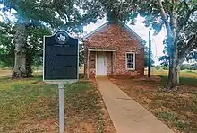
Its former cabin (now preserved in Lubbock), dating from the late 1830s or early 1840s, was probably built by "French" Smith, de la Baume's resident overseer. Its former building served as headquarters for ranching and farming operations until the 1880s and thereafter as tenant quarters, being occupied as late as 1920. It represents the earliest form of dwelling utilized on the Texas frontier. The ranch was acquired in 1897 by Judge Leroy Gilbert Denman (1855–1916), a justice of the Texas Supreme Court, and is owned by his descendants; the cabin was donated to the Ranch Headquarters of the Museum of Texas Tech University by the heirs of Judge Denman.
The property-at-large through its latter liquidation in the mid-1800s, was attached to De la Baume`s 12-acre residence in the "Alameda" of Downtown San Antonio; formerly known as "La Baume Place" in "Cotton Wood Grove," being a "double-stone house" located on East Commerce Street across from the St. Joseph Catholic Church, in what is now a city park. In common, the original will of the property-at-large was signed by the first Texan mayor of San Antonio, John W. Smith.
In 1880, the editors of the San Antonio Express rated the remainder of the “Capote Farm” under its then-new proprietor Major Alexander Moore, as “the largest and most complete farm in Texas...if not in the south;” giving examples of the diversity of livestock and crops that were raised at the scale of 75 workers over 20,000 acres. The farm’s stock included 2,800 heads of cattle, 6,000 Berkshire pigs and various other segments of livestock and agriculture.[117] Within the same time period, the lien on the property was held by the Scottish-American Mortgage Company, Ltd., financiers of the well-known Swan Land and Cattle Co. and Prairie Land and Cattle Co.[118][6][26]
At present day, this property's remaining estate, in its apparent complexity, has generated significant caselaw in Texas, in ConocoPhillips Co. v. Ramirez:[28] "To be entitled to summary judgment on the affirmative defense of limitations, a defendant must prove as a matter of law: (1) the date on which the limitations period commenced, i.e., when the cause of action accrued, and (2) that the plaintiff filed its petition outside the applicable limitations period. In re Estate of Denman, 362 S.W.3d 134, 144 (Tex. App.—San Antonio 2011, no pet.)" Summarily, "[h]olding that residual four-year limitations period of Texas Civil Practice and Remedies Code section 16.051 applies to declaratory judgment action to construe [the will of remaining El Capote Ranch estate]."[27]
Ecology
_and_wildflowers%252C_Nockenut_Road%252C_Guadalupe_County%252C_Texas%252C_USA_(6_October_2018).jpg.webp)
| East Central Texas forests | |
|---|---|
 | |
| Ecology | |
| Realm | Nearctic |
| Biome | Temperate broadleaf and mixed forests |
| Geography | |
| Area | 52,600 km2 (20,300 sq mi) |
| Country | United States |
| State | Texas |
| Conservation | |
| Conservation status | Critical/endangered |
| Habitat loss | 75% |
| Guadalupe River | |
|---|---|
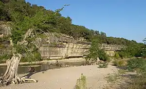 A bluff at Guadalupe River State Park | |
 Map of the Guadalupe River watershed | |
| Location | |
| Country | United States |
| State | Texas |
| Region | Texas Hill Country, Texas Coastal Bend |
| Physical characteristics | |
| Source | Kerr County, Texas |
| • elevation | 676 m (2,218 ft) |
| Mouth | San Antonio Bay, Gulf of Mexico |
• elevation | 0 m (0 ft) |
| Length | 370 km (230 mi) |
| Discharge | |
| • average | 34 m3/s (1,200 cu ft/s) |
The Leesville-Belmont area has an annual average of 33.1 inches and 35.8 days of rainfall. The average day consists of 12.6 hours of light. Temperatures are high with very mild winters. Generally, described as a humid subtropical climate.[119][120]
Subregion
Description
In 1851, William Bollaert FRGS of the Royal Geographical Society became lost in the Leesville area, generally describing it as “Big Hill prairies.” He found the soil to be “rich looking” and “black, reposing upon recent sandstone, forming beautifully undulating lands.” Herds of mustangs, wild horses, wolves and forests of pecan trees were described. Near Guadalupe River, he found the land “fit for all agricultural purposes, although the surface soil is sandy,” the sand upon masses of silicon containing selenite. He found chiltepin peppers to be “most abundant.” The main Capote Hill was described as a “conspicuous object...isolated in the prairie” at “350 feet above.” Within, he found disintegrated limestone, gypsum, oyster and other shells; compromising a great variety of former marine life.[122]
In 1852, Frederick Law Olmsted, then-future designer of New York City’s Central Park; noted the area’s principal species of trees as pecan, hickory, cypress, cotton wood, box elder, white oak and walnut. He described the bottom land's "rich, black clay soil" as difficult to cultivate yet "producing high yields" of agriculture.[32]
Earlier in 1830, Byrd Lockhart described the lands beyond the river as rolling prairie, with sandy hills which were removed far from the Guadalupe River. This "rolling" sandy soil was of lower quality and was found to be covered with post oaks and blackjack oaks.[123] Dr. Ferdinand von Roemer, in 1846, described the area summarily: "...the road leading us in agreeable changes through fertile valleys or over low hills composed of gravel and sand. The country was more settled here, as we came upon farms every few miles."[124][6]
Events
In 1848, over 12,000 bushels of corn were grown and sold in the Capote, Leesville area at 45 cents each; a record-size crop in Southeast Texas for facilities the size of El Capote Ranch, the record held for several years time.[6]
In 1903, implicitly due to heavy rains, cotton crops failed at a rate of one bale per thirty acres of land.[125]
In 1910, an agricultural report in The Houston Post on Leesville, Texas crop conditions indicates excessive dryness with most crops and pastures in a "burned" state; with cotton crops in a derelict state. Local farmers indicated cotton yields had lowered to one bale per 8 acres of land; approximately half of the year before. Corn yields improved year-on-year.[126]
In 1912, Leesville cotton yields were rated as generally poor with corn yields excellent, despite a two-month drought. Hay crops reported satisfactory. The cotton shortfall was reported at a record low since 1904, one-third lower year-on-year.[127]
In 1918, the Dallas "Farm and Ranch" of March 23 reported that G. N. Linecum of Leesville raised 47 bales of cotton in the previous season, on 30 acres of black sandy land "in a drought stricken area of Texas." The result was described to have been achieved through "irrigation from artesian wells and intensive cultivation."[128]
In 1936, Leesville was once established with a number of grocery stores, barbershops, cotton production and a pharmacy; now said to be non-existent and depopulated due to flooding and displacement from a local creek, after 26 inches of sudden rain.[36][129]
Through the summer and fall of 1939, G. A. C. Haiff constructed a bass pond in the Leesville area; producing a 10-inch largemouth black bass in the spring of 1940, as noted by the American Fisheries Society.[130]
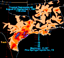
During Tropical Depression Eight of 1981, several dwellings in and around Leesville suffered water damage after the O'Neill Creek reached its highest level since at least 1936. Leesville experienced some part of the county's $5-million estimated damages, caused by the storm.[131]
Culture
Leesville is a hub of the collection of historical remnants and cemeteries it houses, as well as its historical city center acting as an election precinct.
Philosophy
Michael Erskine, a founding settler of the area, described the values of its people summarily in 1845: "I move along here as well as I can—work hard, live poor and am respected by the poor chaps. There are but few rich people in this part of the country. And no claims to be superior to another on account of his wealth."[6]
Politics
As late as 1906, Leesville farmers were majorly unionized under the Leesville Farmers' Union, a focus of Thomas Mitchell Campbell's 1906 Texas gubernational election[125]
During the William Jennings Bryan 1896 presidential campaign, Leesville resident William W. Littlefield (grandfather of George W. Littlefield) acted as a delegate from Texas for the Populist Party, nominating Thomas E. Watson as an alternative vice presidential candidate against the Democratic ticket's Arthur Sewall.[116]
According to The New York Times, during the 2016 United States presidential election, 82% of participating Leesville-Gonzales voters voted for Donald Trump and 16% voted for Hillary Clinton.[132] In Leesville-Belmont-Luling, 79% voted for Trump and 18% voted for Clinton.[133] In Leesville-Seguin, 75% voted for Trump and 21% voted for Clinton.[134]
Cemeteries
- Antioch Cemetery,[135][136] containing the grave of the late Leesville resident, Representative James W. Peebles of the 21st & 22nd Texas Legislature[15]
- Askey African-American Cemetery (unmaintained)[137]
- Caraway Cemetery,[138]
- Dewville Cemetery[139]
- Leesville Cemetery,[140][37][36] acting as an election polling place[141]
- Leesville Latin-American Cemetery, divided and fenced from Leesville Cemetery[142]
- O'Neill Cemetery[143]
- Sandies Chapel Cemetery[144]
- Union Hill Cemetery[145]
Churches
- Camp Valley Full Gospel Church[146]
- Dewville United Methodist Church[147]
- Leesville Baptist Church, held regionally-publicized citywide revivals as late as 1904[148][149][150]
- Leesville Encouraging Word Church, former election polling place[151]
- Leesville Methodist Church,[152][37][36] acting as an election polling place[153][154]
Notable people
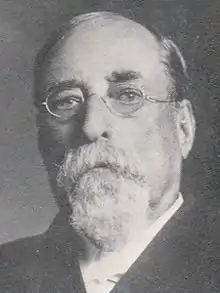
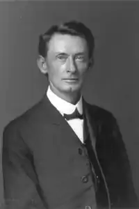
- African-American Los Angeles—Patrolman Frank E. Corley of the LAPD, was born July 14, 1895, in Leesville, Texas. In 1924, leaving behind a wife and two children, he served Los Angeles for only three years before being shot and killed while aiding another police officer. His African-American identity was not revealed until 1998. Notably, alone he had captured an armed bank robber at the Pacific Southwest Bank on LA's 7th Street.[155]
Folklore
In folklore, locals claim to see a ghost of a little girl in a blue dress, playing in Leesville Cemetery; seen only at a significant distance.[156]
Ghost towns
The border of Leesville once acted as a location of these former towns:
Southwest
- Albuquerque, Texas; where outlaw John Wesley Hardin murdered Jack Helm in 1873[157]
- Dewville, Texas; named after the Dew brothers, operators of a local steam-powered gin in 1885[158]
- Sandies Chapel, Texas; named after its former church that was moved to Dewville in 1897[159]
East
- Bebe, Texas; the community had an estimated population of 52 in 2000.[160] A post office called Bebe was established in 1900, and remained in operation until 2002.[161] The community was named after the brand-name Beebee baking powder.[162]
See also
- Montopolis, Austin, Texas
- McNeil, Travis County, Texas
- Del Valle, Texas
- Paradise, Nevada
- Texas Blackland Prairies
- Weeksville, Brooklyn
- Senneville, Quebec
- New Amsterdam (1624-1664), population 270
North of Leesville
South of Leesville
References
- "GNIS Detail - Leesville". U.S. Geological Survey. U.S. Department of the Interior. Retrieved 16 May 2020.
Variant Name...Capote...Leesburg...
- "Lubbock Morning Avalanche, 1926". Retrieved 19 September 2018.
...State of Texas, being a part of the E. W. Cullen League, in the town of Leesville...
- "Library of Congress; Gonzales County, Texas". Retrieved 5 September 2018.
- "...Leesville on the E. W. Cullen league..." Archived from the original on 2018-09-02.
- "TEXAS DISTRICT COURTS". GUADALUPE COUNTY. DISTRICT JUDGES. Retrieved 15 December 2020.
- Muckelroy, Duncan (1974). "History of El Capote Ranch". East Texas Historical Journal. 12 (2). Retrieved 12 May 2020.
- "...The Spanish government made one of the first land grants in the Guadalupe County area to José de la Baume in 1806 for land in the Capote Hills..." Texas State Historical Association. Retrieved 19 September 2018.
- ...Sometime between 1868 and 1887, Mr. Newburn H. Guinn divided land on the west bank of the creek into town lots and sold them to various businesses. In about 1870, Guinn decided to name the town Leesburg, after his daughter, Lee. When the town applied for a post office however, they had to do so under the original name of Capote -- there was already a Leesburg in Texas at the time. The post office opened in 1873. Finally, in 1874, the town became known as Leesville...
- Current name adopted in 1874.
- NEILL, ASSOCIATE JUSTICE. "West v. West, 29 S.W. 242 (Tex. App. 1895)". Court Listener. Court of Appeals of Texas. Retrieved 30 January 2021.
- Davis, Fletcher. The Hondo Anvil Herald. (Hondo, Tex.), Vol. 51, No. 52, Ed. 1 Friday, July 9, 1937, newspaper, July 9, 1937; Hondo, Texas.
- Leila Guinn Miller (1854-1937)
- Reports of Cases Argued and Adjudged in the Court of Appeals of Texas, Volume 19, Page 644. Texas Court of Appeals. 1885. Retrieved 6 April 2020.
- Personnel of the Texas State Government with Sketches of Distinguished Texans, 21st Legislature; Biographical sketch, James William Peebles (PDF). State of Texas. 1889. pp. 236–238. Retrieved 5 April 2020.
- "James Wiley Peebles". Legislative Reference Library of Texas. State of Texas. Retrieved 5 April 2020.
- "AREA CHARACTERISTICS". Archived from the original on 2020-02-13. Retrieved 2018-08-28.
- "Capote Hills". TSHA Handbook of Texas. Texas State Historical Association. Retrieved 9 September 2020.
- "384". United States Census Bureau. Retrieved 15 August 2020.
- "Southeast Guadalupe CCD, Guadalupe County, Texas -- Rural". United States Census Bureau. Retrieved 25 August 2020.
- "United States Postal Service". Retrieved 11 December 2018.
- "Bridges". Engineering News and American Railway Journal. 41: 72. 1899. Retrieved 14 May 2020.
...Bids are asked...for constructing two iron bridges, one over Sandies Creek...
- Sjoberg, Brooke. "Early voting starts Oct. 13". The Gonzales Inquirer. Gonzales County, Texas. Retrieved 13 October 2020.
On Election Day, Nov. 3, each precinct will report as follows:..13: Leesville Methodist Church- Election Room, 6077 CR 155...
- STEVEN C. HILBIG, JUSTICE (2008). "IN RE: ESTATE OF Gilbert M. DENMAN". FindLaw. Court of Appeals of Texas, San Antonio. Retrieved 4 January 2021.
...real property in Guadalupe and Gonzales Counties as well as the animals and farm equipment thereon. This property is known as El Capote Ranch (“the Ranch”)...
- Ezekiel Wimberly Cullen (1814-1882)
- "La Baume of Bexar...He soon became interested, along with several Anglo settlers in purchasing more land, specifically, a 26,568 acre tract among the Capote Hills. Acting governor Manuel Antonio Cordero y Bustamante granted the right to the land purchase..." Archived from the original on 5 September 2018. Retrieved 5 September 2018.
- "El Capote Cabin, National Ranching Heritage Center". Library of Congress. National Ranching Heritage Center. Retrieved 12 May 2020.
 This article incorporates text from this source, which is in the public domain.
 - MARIALYN BARNARD, JUSTICE (2011). "Estate of Denman". Casetexas. Court of Appeals of Texas, Fourth District, San Antonio. Retrieved 4 January 2021.
- Rebeca C. Martinez, Justice (2017). "ConocoPhillips Co. v. Ramirez". Casetext. Court of Appeals of Texas, San Antonio. Retrieved 4 January 2021.
- "The George Washington Littlefield Building".
- Gracy, David B. (1971). George Washington Littlefield: A Biography in Business. Texas Tech University.
- Haley, J. Evetts. George W. Littlefield, Texan. University of Oklahoma Press.
- Olmsted, Frederick (1852). A Journey Through Texas (Republished). New York, 1969. pp. 231–237.CS1 maint: location (link)
- "Leesville, Texas". The Handbook of Texas online. Retrieved 2009-08-29.
- "Leesville, Texas". Texas Escapes Online Magazine. Retrieved 2009-08-29.
- The annual Come and Grind It gravel road cycling event is back in Leesville for the fourth year in a row. The ever-growing race, starting with 125 participants in 2017 which ballooned to 225 racers (in 2019)...at 6077 County Road 155 Leesville, Texas...The race includes a 22, 33 and 66-mile option.
- "Leesville celebrates 80th homecoming". Retrieved 21 August 2018.
Used to be, a couple of thousand people lived in the area. There were two barbershops, two grocery stores, a cotton gin and a drug store...the flood of 1936 caused hardships that changed the dynamics of Leesville’s development in forcing people to move elsewhere.
- "Leesville lets loose this weekend...at the Methodist Church grounds, is a fundraiser for the Leesville Cemetery". Retrieved 21 August 2018.
- ...center of each city listed is within 59 miles of Leesville, TX...
- "Aggregate self-employment income in the past 12 months (in 2016 inflation-adjusted dollars); 1,314,300". Archived from the original on 2020-02-13. Retrieved 2018-08-28.
- "AGGREGATE HOUSEHOLD INCOME IN 1999 (DOLLARS) BY TENURE AND MORTGAGE STATUS...7,864,200". Archived from the original on 2020-02-13. Retrieved 2018-08-28.
- "10637800". United States Census Bureau. Retrieved 15 August 2020.
- "Aggregate real estate taxes paid (dollars): 192,500". Archived from the original on 2020-02-13. Retrieved 2018-08-28.
- "District Traffic and Urban Saturation Web Maps (2019)". Transportation Planning Maps. Texas Department of Transportation. Retrieved 23 August 2020.
- "249". United States Census Bureau. Retrieved 15 August 2020.
- "1,253". United States Census Bureau. Retrieved 15 August 2020.
- "825; 184". United States Census Bureau. Retrieved 15 August 2020.
- "CONTRACT RENT". United States Census Bureau. Retrieved 15 August 2020.
- "GONZALES COUNTY, TEXAS; SUBDIVISION RULES" (PDF). Texas Association of Counties. Retrieved 15 August 2020.
- "SELECTED HOUSING CHARACTERISTICS". United States Census Bureau. Retrieved 15 August 2020.
- "MONTHLY HOUSING COSTS...Median (dollars)...546". Archived from the original on 2020-02-13. Retrieved 2018-08-28.
- "633". United States Census Bureau. Retrieved 15 August 2020.
- "AGGREGATE REAL ESTATE TAXES (DOLLARS)...23,500". Archived from the original on 2020-02-13. Retrieved 2018-08-28.
- "TRAVEL TIME TO WORK...U.S. Census Bureau, 2012-2016 American Community Survey 5-Year Estimates". Archived from the original on 2020-02-13. Retrieved 2018-08-28.
- "YEAR STRUCTURE BUILT...1980 to 1999, 40.5%". Archived from the original on 2020-02-13. Retrieved 2018-08-28.
- "Median year householder moved into unit...1996". Archived from the original on 2020-02-13. Retrieved 2018-08-28.
- "AGGREGATE VALUE (DOLLARS) FOR ALL OWNER-OCCUPIED HOUSING UNITS...13,985,000". Archived from the original on 2020-02-13. Retrieved 2018-08-28.
- "19645000". United States Census Bureau. Retrieved 15 August 2020.
- "78122...262.93 acres...South #80, Leesville, TX is a vacant land...sold for $1,222,361 in January 2020". Retrieved 26 January 2020.
- "$1,573,425 - 315 acres...CR 105 , Leesville, TX". Retrieved 16 April 2020.
- Erskine, Michael (August 21, 1862). "Inventory and Appraisement of Community Property". Gonzales—Guadalupe County Records. Gonzales—Guadalupe County, Texas.
- Erskine, John (December 7, 1872). "Inventory and Appraisement of Estate". Gonzales—Guadalupe County Records.
- "Abstract of Title". Compilations of Dibrell and Mosheim Abstract Co. Seguin, Texas. September 25, 1897.
- United States Postal Service...9606 N STATE HIGHWAY 80 LEESVILLE, TX 78122-9998
- A review of business activities of the Post Office at this location revealed that the office workload has declined. This reduced workload suggests the maintenance of an independent Post Office here may no longer be warranted.
- "School District Locator". The State of Texas. Texas Education Agency. Retrieved 28 May 2020.
- ...the Nixon-Smiley CISD school board election...The poll places include...Leesville Methodist Church, FM 1682, Leesville (Precincts: 5, 13)...
- Quilters keep patching a tradition since 1998...a group known as the Happy Quilters were hard at work on the premier attraction for the auction — a handmade quilt that brings in big bucks for the annual fundraiser...All agreed that the quilt is the big auction item that everyone looks forward to at the fair, with the highest bid fetching $2,000 one year, but the average is $1,000 or so. The money raised from the quilt and the fair goes to two scholarships for Nixon-Smiley students, upkeep of the old Methodist Church building — which is now used as a community center for the Leesville Cemetery Association — and upkeep of the cemetery next door...
- Handmade quilt takes center stage at annual fair
- ...”We need to get something done about a certain property in the Leesville community”...Commissioner Donnie Brzozowski proposed that per state law, the constable for the precinct in question should be responsible for enforcing the laws that require people to keep their property cleaned up...
- "Proposed City of Capote Hills" (PDF). Guadalupe County General and Special Elections. Retrieved 18 May 2020.
- "...40-mile pipeline runs from western Gonzales County to Seguin and Schertz, where the water is delivered..." San Antonio Express-News. Hearst. Retrieved 21 July 2020.
- "...The decision was made to expand the existing supplies from both Gonzales and Guadalupe groundwater options. This provided the most reliable and cost effective long-term supply..." Groundwater Transmission and Treatment System Gonzales Well Field Project. Walker Partners; Engineers, Surveyors. Retrieved 21 July 2020.
- "...to secure water from the Carrizo-Wilcox Aquifer in neighboring Gonzales and Guadalupe Counties..." Fitch Ratings. Retrieved 21 July 2020.
- "State & County QuickFacts". United States Census Bureau. Archived from the original on July 28, 2011. Retrieved December 16, 2013.
- "Find a County". National Association of Counties. Archived from the original on 2011-05-31. Retrieved 2011-06-07.
- Dorcas Huff Baumgartner; Genevieve B. Vollentine (June 15, 2010). "Gonzales County". Handbook of Texas Online. Texas State Historical Association. Retrieved June 20, 2015.
- "Gonzales County". Texas Almanac. Texas State Historical Association. Retrieved June 20, 2015.
- Sjoberg, Brooke. "Pay a concern at meeting". The Gonzales Inquirer. Retrieved 14 August 2020.
- "Gonzales County, Texas". Census Data. United States Census Bureau. Retrieved 14 August 2020.
- "Gonzales County". Texas Almanac. Texas State Historical Association. Retrieved 9 November 2020.
- "Texas Parks and Wildlife Department". Retrieved 16 January 2020.
- ...Whitney Pena, a member of the Leesville 4-H Club, showed the grand champion market hog. It was purchased for $1,400 by CGP Manufacturing Co...Keith Clifton, a member of the Leesville 4-H Club, showed the grand champion broilers. His chickens were purchased for $1,400 by State Bank of Gonzales, Holmes Foods and Nixon Feed. The reserve grand champion broilers were shown by Kayla Elkins, a senior at Nixon-Smiley High School and a member of the Leesville 4-H Club. Her chickens were bought for $750 by Tyson Foods....
- "Reward offered for stolen ranch sign". The Gonzales Inquirer. Retrieved 7 December 2020.
- The Cattleman (Volume 60 ed.). Pennsylvania State University: Texas and Southwestern Cattle Raisers Association, Texas Hereford Association. 1973. p. 132. Retrieved 19 April 2020.
- "Blood Will Tell". The Cattleman, Volume 41. 1954. Retrieved 17 June 2020.
- "Texas Parks and Wildlife Department". Retrieved 2 September 2018.
- "International airports near 78122". Retrieved 18 April 2020.
- "Population and Housing Unit Estimates". Retrieved May 21, 2020.
- The Seguin-Gazette Enterprise (September 23, 1998); 'Sandies Home Guard' of 1861 muster printed...A list of officers and members composing of the Voluntary Cavalry Company known as the "Sandies Home Guard" was organized on June 25, 1861 in Gonzales County. This company consisted of 70 men, including officers. Most of the men agreed to equip themselves with a good reliable gun, either a rifle or a shot gun, a six shooter and a good horse fit for service. Most of the company had rifles, some shot guns and some of them had six shooters. The recruits who did not have arms assured Erskine that they would be procured on reasonable terms as soon as possible. The names of those appearing on this muster are listed as follows. Officers: Captain Michael Erskine, First Lieutenant W. H. Burris, Second Lieutenant Larkin N. West, Third Lieutenant N. W. Guinn...
- At Sandies...In 1861 a volunteer cavalry company was formed. Called the Home Guard it was organized by Capt. Michael Erskine and was made up of 70 men.
- Houston Daily Post...Leesville, Texas, July 9 (1904)...In the primary election, the following vote was cast at this box: Schuter 2, Davidson 61, Simmons 19, Blanchette 31, Stephens 64, Robbins 67, Strong 27, Lefevre 643, Cousins 65...(Lefvre-Cousins Superintendent Vote: 708 ballots)
- Reports of Cases Argued and Adjudged in the Court of Appeals of Texas, Volume 19, Page 642. Texas Court of Appeals. 1885. Retrieved 6 April 2020.
- ...early settlers used to gather by Sandies Creek around a huge granite stone. From the 1830s until 1870, it was a spot for revivals, picnics and general get-togethers...The landowner of the property adjacent to this granite gathering became quite annoyed...They would raid his fields for watermelon, corn and other food. So, in 1870, he blew up the piece of granite.
- "Annual Report of the Commissioner of Patents". U.S. Government Printing Office, 1886. 1886.
- "Patent for a new and improved advertising sign. This design "relates to apparatus or devices for marking or indicating upon the outside of boxes or drawers the names and prices of the merchandise or other articles contained therein; and it consists in the improved construction and combination of parts of a device of the above-mentioned class"". University of North Texas. Retrieved 15 June 2020.
- "Patent for a new and improved merchandise tag. This design consists of a stick "provided with means for holding it fixed in its position after it has been inserted and having hinged to its outer end the tag having a strip of suitable material secured around its edges, as shown, so as to form on both sides of the tag the flanges adapted to receive the removable, reversible, and interchangeable cards". University of North Texas. Retrieved 15 June 2020.
- ...One of the first businesses began there in the 1860s when Sylvester A. Hubbard built an ox-powered treadmill to grind corn and saw lumber. In 1868, Daniel Brown and his brother opened the first general merchandise store to be located at old Capote. About the same time, a brick kiln along with a saddletree and stirrup factory began operations...the Leesburg (Leesville) Male and Female Institute on January 21, 1873...At one time the school system had an accredited high school. It was later consolidated with the Nixon Independent School District. The last high school class graduated in 1947, but four elementary grades were taught at Leesville until 1951...The economy of Leesville depended mostly on cutting and selling oak as well as, other hardwood for use as building material. The residents also raised grain and cattle. Cotton became the big money crop after the Civil War, with three cotton gins operating at the same time. In later years, ranching along with peanut and melon farming contributed to the local economy...
- Reports of Cases Argued and Adjudged in the Court of Appeals of Texas, Volume 19, Page 638. Texas Court of Appeals. 1885. Retrieved 6 April 2020.
- Morcombe, Joseph; Pride, Richard (1905). The American Tyler (Volume 19 ed.). University of Michigan: J. H. Brownell. p. 307. Retrieved 7 May 2020.
- ...One of the volunteer companies that organized in Gonzales County was the Sandies Home Guard. The Sandies Home Guard was organized June 22, 1861...under Captain Michael Erskine...The guard’s name probably came from Sandies Creek or Sandies Hill in Leesville, TX.
- The Era Druggist's Directory of the United States, Canada, Cuba, Porto Rico, Manila, Hawaiian Islands and Mexico. University of Michigan: D.O. Haynes & Company. 1916. p. 172. Retrieved 21 April 2020.
- "Antique Small Pharmacy Medicine Box, L. C. Locke (sic), Leesville, Texas, 1890s". Retrieved 21 April 2020.
Antique small pharmacy paper slide box, L. C. Cocke, Leesville, Texas, from the 1890s, 2 1/4" x 1 1/4", some rough areas on label (some small bits gone and wear, etc.)
- Eugene Daniel, Ferdinand (1894). Medical Insurance, Devoted to the Insurance Examiner and Clinical Diagnostician (Volume 9 ed.). University of Michigan: Texas Medical Journal. p. 414. Retrieved 19 April 2020.
- Former track mapped alongside West FM 466 and South SH 80
- United States Interstate Commerce Commission (1932). Interstate Commerce Commission Reports: Decisions of the Interstate Commerce Commission of the United States. Valuation reports, Volume 36. U.S. Government Printing Office, 1932.
- San Antonio Express. (San Antonio, Tex.), Vol. 48, No. 194, Ed. 1 Sunday, July 13, 1913
- HOUSTON DAILY POST...LEESVILLE, Texas...March 10 (1912) The Quanah and Gulf railroad Is now being surveyed two and one-half miles east of this place. The citizens are anxious to induce the road to come by Leesville and a nice bonus will be offered when building begins.
- Engineering and Contracting (No. 17, Volume 37 ed.). University of Michigan: Myron C. Clark Publishing Company. 1912. p. 37. Retrieved 19 April 2020.
- Mason Camp, Walter (1916). Railway Review (No. 1, Volume 59 ed.). New York Public Library: W.A. Smith. p. 678. Retrieved 19 April 2020.
- The Lumber Trade Journal (Volume 70 No. 11 ed.). Pennsylvania State University. 1916. p. 46. Retrieved 29 April 2020.
- ...Leesville...marker...for the 1835 attack at Sandies Water Hole, where a party of 13 French and Mexican traders was ambushed by Comanches while going from Natchitoches, LA. to Mexico. All died...
- The Black Diamond (Volume 30, No. 201 ed.). University of Chicago. 1903. p. 903. Retrieved 29 April 2020.
- Houston Post Special...LEESVILLE, Texas, January 22 (1909)...Three miles north of this place a dozen or more cases of smallpox exist. It has prevailed almost continuously in some part of this county for many months and only one case (that in the town of Gonzales) has been quarantined. If quarantine is not immediately established there soon may be a hundred cases, as it is among (African-Americans) and they are traveling night and day, some with it broken out on them.
- WILLIAM W. LITTLEFIELD has for practically half a century been actively identified with the farming and stock-raising interests of Gonzales County, his home being at Leesville, and he has also for a number of years been a prominent political figure in that section of the state. The Littlefield family has been one of prominence in Texas and elsewhere for a number of generations. The name is of Scotch origin, and Philip Littlefield, grandfather of the Leesville resident, was one of three brothers who left the old country and came to the United States about 1801...
- ...A triple tragedy lately took place at Leesville, Texas. Three leading citizens and brothers, Houston, William and Phipps Littlefield, while working on a road, met Orvie, James, and Edward Martin. Houston Littlefield had had a previous difficulty with the party, and separated without settling it. Meeting again, they renewed the quarrel. Houston Littlefield drew his pistol on Orvie Martin, who was unarmed. James Martin, seeing his brother in danger, ran up and struck Houston Littlefield with a hoe, felling him to the ground. At that Phipps Littlefield drew his revolver and shot James Martin, the ball hitting him on the head. By this time all hands had drawn revolvers, and a general fire began. Ed. Martin was wounded in the hand, but not before he had shot and instantly killed Houston and William Littlefield. The two Littlefields lay dead, while their brother, mortally wounded-cast his dying gaze upon their ghastly bodies, reddened with gore. The Martins then left...Phipps Littlefield died a few hours after the fight. It is thought the Littlefield family connections will take up the fight and wreak vengeance on the Martins.
- Johnson, Frank (1916). A History of Texas and Texans. Chicago: The American Historical Society. pp. Vol. IV, 1670–1672.
- Mickle, Hans (January 20, 1880). "Story tells of one year's labor on Capote Farm". San Antonio Express (Republished by The Seguin Gazette-Enterprise). Retrieved 15 May 2020.
- "Texas Historical Marker - El Capote Ranch". Archived from the original on 2016-03-04. This article incorporates text from this source, which is in the public domain.
- MONTHLY - ALL WEATHER AVERAGES
- Climate Summary
- This article incorporates public domain material from the United States Geological Survey document: "Ecoregions of Texas poster, back" (PDF). Retrieved 2016-02-06.
- Bollaert FRGS, William (1851). "Observations on the Geography of Texas". The Journal of the Royal Geographical Society. University of California. 20: 119. Retrieved 12 May 2020.
- Byrd Lockhart's Field Notes of 6 Leagues of Capote tract. Seguin, Texas: Personal Papers of Mrs. Charles E. Baer. June 14, 1830.
- Roemer, Dr. Ferdinand (1846). Texas: Described Through Personal Observations (Republished). San Antonio, 1935. pp. 86–90.CS1 maint: location (link)
- "Farmers' Union at Leesville".
Farmers' Union at Leesville. (Houston Post Special.) LEESVILLE Texas. July 18 (1906) J. C. Albritton at 3 p.m. yesterday addressed a large audience at this place upon the aims and purposes of the Farmers' Union after which a number of the candidates for county offices addressed the assembly. Mr. Hicks of San-Antonio is billed to address the people at this place on the 19th instant in behalf of T. M. Campbell for governor who has a number of supporters but Colquitt Is largely In the majority with none so far heard of for Brooks and but one for Bell. This section received a heavy rain last night which will be very detrimental to cotton causing It to shed many of its forms and will cause a rapid Increase of boll weevils from which many farmers fear another 1903 failure when this section averaged about a bale to thirty acres.
- HOUSTON DAILY POST...August 4, 1910...LEESVILLE Texas. August 3.-It Is exceedingly dry In this section and all crops and pastures arc about burned up. Half of the leaves and all squares and small bolls on the 'cotton have fallenoff. The opinion of farmers are that it will require eight acres to make a bale of cotton; that It Is the shortest cotton crop since 1904. Picking Is now pretty general and gins are now running every day. If this dry weather continues all will open this month and soon be gathered. Corn Is some better than last year but cotton about half.
- LEESVILLE COTTON POOR. Corn Is Excellent Despite Two Months Without Rain. Houston Post Special. LEESVILLE Texas August 26 (1912) There has been no rain In this section for over two months and only partial showers In county. Farmers have made fine corn and hay crops but cotton Is shortest since 1904. From Interviews with a great number of leading farmers we find they agree that cotton Is one-third shorter than last year. Very nearly all cotton is opened and being gathered very slowly on account of scarcity of cotton pickers. A large majority of Mexicans have left this country since the rebellion In Mexico.
- Commerce and Finance (No. 14, Volume 7 ed.). The Ohio State University: Theodore H. Price Publishing. April 3, 1918. p. 361. Retrieved 19 April 2020.
- ...On June 30, 1936, over 26 inches of rain devastated the town and the surrounding area. After the flood, many people moved out. Although some businesses were rebuilt a half mile west of the original site on Highway 80 -- the flood signaled an end to any future growth for the town...Leesville still exists, to some extend, and although it may not be the thriving place that it once was, before the great flood in 1936 -- the memories remain for those folks who were brought up there and the people who still call Leesville, home...
- Transactions of the American Fisheries Society. University of California: American Fisheries Society. 1943. p. 71. Retrieved 29 April 2020.
- "Storm Data and Unusual Weather Phenomena" (PDF). Storm Data. Asheville, North Carolina: National Climatic Data Center. 23 (8). August 1981. ISSN 0039-1972. Retrieved June 26, 2017.
- "An Extremely Detailed Map of the 2016 Election (Leesville-Gonzales)". New York Times. Retrieved 10 June 2020.
- "An Extremely Detailed Map of the 2016 Election (Leesville-Belmont-Luling)". New York Times. Retrieved 10 June 2020.
- "An Extremely Detailed Map of the 2016 Election (Leesville-Seguin)". New York Times. Retrieved 10 June 2020.
- ...Highway 80...Leesville...battle was near the Antioch Cemetery...
- Antioch Cemetery Photos
- Askey Cemetery African American...Memorials...20...No maintenance, in bad condition.
- Caraway Cemetery Photos
- Dewville Cemetery...Also known as Dewville I.O.O.F. Cemetery...Memorials...473
- Gravel bike race success in...Leesville Cemetery
- Pct. 13 – Leesville Cemetery Assn., 1677 CR155
- 6077 CR 155...Leesville, Gonzales County, Texas...Memorials...23...Cemetery is located next to the Leesville Cemetery behind the Leesville Baptist Church. There is a fence that divides the cemeteries.
- O'Neill Cemetery...Leesville, Gonzales County, Texas...Memorials...9...Cemetery located on private property.
- Sandies Chapel Cemetery...Memorials...91
- Union Hill Cemetery...Leesville, Gonzales County, Texas, USA...Memorials...204
- ...Camp Valley Full Gospel Church in Leesville, Texas...
- Dewville United Methodist Church, 5755 CR 121, Leesville, TX 78122
- Leesville Excited. Houston Post Special, April 16 (1904)...The revival conducted at the Baptist church is taking on great interest. All of the stores close in the town every afternoon for the 3 to 4 o'clock services....
- Lillie Lea Lay...Contributions may be made to the Leesville Baptist Church
- Genelda Talley Pruett...contributions may be made to...Leesville Baptist Church
- ...Election Day voting is usually held at...Leesville Encouraging Word Church...but certain factors came into play requiring a couple of adjustments...
- Leesville Country Fair takes place Saturday...Leesville Methodist Church grounds
- February 27, 2020...ELECTION DAY POLLING LOCATIONS...Leesville Methodist Church...6077 CR 155...
- Leesville Methodist Church, FM 1682, Leesville (Precincts: 5, 13)
- Thomas, Lieutenant John (May 2003). "Los Angeles Police BEAT" (PDF). Office of the Chief of Police. p. 4. Retrieved 17 April 2020.
- The Leesville Cemetery Ghost...Many people have reported seeing a little girl in the Leesville cemetery, and they always see her from a distance. They also say the same thing – that she wears a blue dress and is playing in the graveyard like a living child would do in a schoolyard. But the second someone starts to walk toward her, she disappears...
- Albuquerque was on the Clear Fork of Sandies Creek two miles south of the junction of Gonzales, Wilson, and Guadalupe counties in Gonzales County. The site was believed to be in Wilson County until a 1914 survey showed it inside the Gonzales county line...
- Dewville is at the intersection of a country road and Farm Road 1117, near the southwestern corner of Gonzales County twenty-five miles southwest of Gonzales...
- Sandies Chapel was on a country road off Farm Road 1116 near the confluence of McCoy and Sandies creeks twenty-five miles southwest of Gonzales in southwestern Gonzales County...
- "Bebe, Texas". The Handbook of Texas online. Retrieved 2009-11-07.
- "Gonzales County". Jim Forte Postal History. Archived from the original on 4 March 2016. Retrieved 17 August 2015.
- Tarpley, Fred (5 July 2010). 1001 Texas Place Names. University of Texas Press. p. 21. ISBN 978-0-292-78693-6.
General references
Newspaper references
- Lockhart Post Register
- Port Arthur News (1921–2014)
- Rosebud News (1953–1977)
- Seguin Gazette
- Seguin Gazette Enterprise
- Shiner Gazette
External links
| Wikimedia Commons has media related to Leesville, Texas. |
| Sandies Home Guard | |
|---|---|
 Captain C.S.A., rank of Sandies Home Guard commanding officer | |
| Active | American Civil War |
| Country | Confederate States of America |
| Branch | Confederate States Army |
| Type | Confederate Home Guard |
| Size | 70 |
| Part of | Militia |
| Garrison/HQ | Sandies Creek (later Leesville), Texas |
| Anniversaries | June 22, 1861 (mustered June 25) |
| Commanders | |
| Notable commanders | Captain Michael Erskine; First Lieutenant W. H. Burris; Second Lieutenant Larkin N. West; Third Lieutenant N. W. Guinn |
- Sandies Creek, Leesville, Texas
- Newspaper Archives; Leesville, Texas
- Leesville, Gonzales Inquirer (No Obituaries)
- U.S. Geological Survey Geographic Names Information System: Leesville, Texas
- Leesville, Texas from the Handbook of Texas Online
- 19th Century Divorce Case; Leesville, Texas
- Auctioned Campbell jersey won at Leesville fair
Municipalities and communities of Guadalupe County, Texas, United States | ||
|---|---|---|
| Cities | 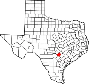 Guadalupe County map | |
| CDPs |
| |
| Other unincorporated places |
| |
| Ghost towns |
| |
| Footnotes | ‡This populated place also has portions in an adjacent county or counties | |
| ||
Municipalities and communities of Gonzales County, Texas, United States | ||
|---|---|---|
| Cities |  Gonzales County map | |
| Unincorporated areas | ||
| Ghost towns |
| |
| Footnotes | ‡This populated place also has portions in an adjacent county or counties | |
| ||
