Houston County, Minnesota
Houston County is a county in the U.S. state of Minnesota. At the 2010 United States Census, the population was 19,027.[1] Its county seat is Caledonia.[2]
Houston County | |
|---|---|
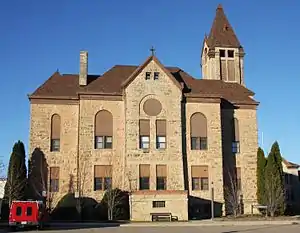 Houston County Courthouse in Caledonia | |
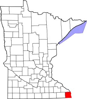 Location within the U.S. state of Minnesota | |
 Minnesota's location within the U.S. | |
| Coordinates: 43°40′N 91°29′W | |
| Country | |
| State | |
| Founded | February 23, 1854 (created) April 4, 1854 (organized) |
| Named for | Sam Houston |
| Seat | Caledonia |
| Largest city | La Crescent |
| Area | |
| • Total | 569 sq mi (1,470 km2) |
| • Land | 552 sq mi (1,430 km2) |
| • Water | 17 sq mi (40 km2) 2.9%% |
| Population (2010) | |
| • Total | 19,027 |
| • Estimate (2019) | 18,600 |
| • Density | 33.8/sq mi (13.1/km2) |
| Time zone | UTC−6 (Central) |
| • Summer (DST) | UTC−5 (CDT) |
| Congressional district | 1st |
| Website | co.houston.mn.us |
Houston County is included in the La Crosse-Onalaska, WI-MN Metropolitan Statistical Area.
History
The area covered by today's Houston County was first organized as St. Croix County, of the Wisconsin Territory, in 1839.[3] On October 27, 1849, part of that county was partitioned off to create Wabashaw County of the Minnesota Territory.[4] On February 23, 1854, the territorial legislature authorized the partitioning of sections of Wabashaw to create Fillmore County[5] and Houston County.[6] An election on April 4, 1854, allowed the county government to be completed.[7] The county was named for Sam Houston, who had been president of the Republic of Texas and a US senator from Texas.[8] The village of Houston was the first county seat. Then a land speculator made an effort to move the seat to Caledonia, and in 1855 the county board moved the county records to Caledonia, which became the de facto seat, and eventually the legal seat after several county votes. In 1855 the records were stored in the cabin of Commissioner Samuel McPhail; the first court hearings were held in that cabin, and a one-story courthouse and jail was built in Caledonia in 1857. A two-story building was built in Caledonia in 1867, and several referenda made Caledonia the county seat by 1874.[9] From that point on, Caledonia prospered and Houston slowly declined. The only other area of prominence was La Crescent, which benefited from its connection to La Crosse, Wisconsin.
Geography
Houston County is at Minnesota's southeast corner. Its eastern border abuts Wisconsin (across the Mississippi River) and its southern border abuts Iowa. The Mississippi flows south-southeast along its eastern border. The Root River flows east through the northern part of the county, discharging into the Mississippi. Pine Creek flows east-southeast through the northeastern part of the county to discharge into the Mississippi, while Crooked Creek flows east across the southern part of the county to discharge into the Mississippi. The county's terrain consists of low rolling hills on its western end, transitioning to hills carved with drainages toward the east.[10] The central and western portion of the county is a plateau with its highest point at 1,273' (388m) ASL, near its southwest corner.[11] The county has a total area of 569 square miles (1,470 km2), of which 552 square miles (1,430 km2) is land and 17 square miles (44 km2) (2.9%) is water.[12]
The county is in the Driftless Zone, marked by the absence of glacial drift and presence of bedrock cut by streams into steep hills. The plateau that surrounds Caledonia includes flat, fertile farm land and hilly, verdant pasture land.
Lakes[10]
The Upper Mississippi River National Wildlife and Fish Refuge runs along the county's eastern border. Four lakes in that Refuge fall within the county:
- Blue Lake
- Hayshore Lake
- Lawrence Lake
- Target Lake
Adjacent counties
- Winona County - north
- La Crosse County, Wisconsin - northeast
- Vernon County, Wisconsin - east
- Allamakee County, Iowa - south
- Winneshiek County, Iowa - southwest
- Fillmore County - west
Protected areas[10]
- Beaver Creek Valley State Park
- Mound Prairie Scientific and Natural Area
- Upper Mississippi River National Wildlife and Fish Refuge (part)
Demographics
| Historical population | |||
|---|---|---|---|
| Census | Pop. | %± | |
| 1860 | 6,645 | — | |
| 1870 | 14,936 | 124.8% | |
| 1880 | 16,332 | 9.3% | |
| 1890 | 14,653 | −10.3% | |
| 1900 | 15,400 | 5.1% | |
| 1910 | 14,297 | −7.2% | |
| 1920 | 14,013 | −2.0% | |
| 1930 | 13,845 | −1.2% | |
| 1940 | 14,735 | 6.4% | |
| 1950 | 14,435 | −2.0% | |
| 1960 | 16,588 | 14.9% | |
| 1970 | 17,556 | 5.8% | |
| 1980 | 18,382 | 4.7% | |
| 1990 | 18,497 | 0.6% | |
| 2000 | 19,718 | 6.6% | |
| 2010 | 19,027 | −3.5% | |
| 2019 (est.) | 18,600 | [14] | −2.2% |
| US Decennial Census[15] 1790-1960[16] 1900-1990[17] 1990-2000[18] 2010-2019[1] | |||
2000 census
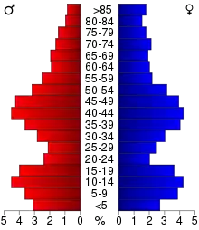
At the 2000 United States Census,[19] there were 19,718 people, 7,633 households and 5,411 families in the county. The population density was 35.7/sqmi (13.8/km2). There were 8,168 housing units at an average density of 14.8/sqmi (5.71/km2). The racial makeup of the county was 98.47% White, 0.31% Black or African American, 0.18% Native American, 0.37% Asian, 0.02% Pacific Islander, 0.14% from other races, and 0.51% from two or more races. 0.61% of the population were Hispanic or Latino of any race. 43.1% were of German, 29.6% Norwegian and 7.5% Irish ancestry.
There were 7,633 households, of which 34.4% had children under the age of 18 living with them, 60.0% were married couples living together, 7.4% had a female householder with no husband present, and 29.1% were non-families. 25.4% of all households were made up of individuals, and 12.0% had someone living alone who was 65 years of age or older. The average household size was 2.53 and the average family size was 3.05.
The county population contained 27.2% under the age of 18, 6.8% from 18 to 24, 26.8% from 25 to 44, 23.1% from 45 to 64, and 16.0% who were 65 years of age or older. The median age was 39 years. For every 100 females there were 97.5 males. For every 100 females age 18 and over, there were 95.1 males.
The median household income was $40,680 and the median family income was $49,196. Males had a median income of $32,557 and females $22,158. The per capita income was $18,826. About 4.2% of families and 6.5% of the population were below the poverty line, including 6.4% of those under age 18 and 11.2% of those age 65 or over.
Transportation
Major highways
Airport
Communities
Cities
- Brownsville
- Caledonia (county seat)
- Eitzen
- Hokah
- Houston
- La Crescent (partly in Winona County)
- Spring Grove
Unincorporated communities
Townships
- Black Hammer Township
- Brownsville Township
- Caledonia Township
- Crooked Creek Township
- Hokah Township
- Houston Township
- Jefferson Township
- La Crescent Township
- Mayville Township
- Money Creek Township
- Mound Prairie Township
- Sheldon Township
- Spring Grove Township
- Union Township
- Wilmington Township
- Winnebago Township
- Yucatan Township
Government and politics
Houston County voters have tended to vote Republican in the past few decades. As of 2016 the county selected the Republican candidate in 67% of presidential elections since 1980.
| Year | Republican | Democratic | Third parties |
|---|---|---|---|
| 2020 | 55.4% 6,334 | 42.4% 4,853 | 2.2% 253 |
| 2016 | 53.0% 5,616 | 39.1% 4,145 | 8.0% 843 |
| 2012 | 47.4% 4,951 | 50.6% 5,281 | 2.1% 214 |
| 2008 | 43.6% 4,743 | 54.3% 5,906 | 2.2% 234 |
| 2004 | 50.8% 5,631 | 47.6% 5,276 | 1.6% 175 |
| 2000 | 49.9% 5,077 | 44.3% 4,502 | 5.8% 588 |
| 1996 | 38.9% 3,674 | 44.0% 4,153 | 17.2% 1,623 |
| 1992 | 36.9% 3,853 | 35.8% 3,744 | 27.3% 2,854 |
| 1988 | 54.1% 4,777 | 44.6% 3,936 | 1.3% 112 |
| 1984 | 61.1% 5,645 | 38.0% 3,512 | 1.0% 88 |
| 1980 | 58.9% 5,582 | 33.9% 3,218 | 7.2% 681 |
| 1976 | 54.4% 4,853 | 43.3% 3,861 | 2.4% 212 |
| 1972 | 66.6% 5,186 | 31.7% 2,467 | 1.8% 137 |
| 1968 | 57.9% 4,450 | 35.2% 2,703 | 6.9% 528 |
| 1964 | 46.9% 3,433 | 53.0% 3,885 | 0.1% 8 |
| 1960 | 60.9% 4,807 | 39.0% 3,080 | 0.0% 3 |
| 1956 | 67.9% 4,538 | 31.9% 2,133 | 0.1% 9 |
| 1952 | 74.3% 5,365 | 25.3% 1,830 | 0.4% 28 |
| 1948 | 56.8% 3,540 | 42.1% 2,623 | 1.1% 68 |
| 1944 | 68.3% 4,036 | 31.3% 1,847 | 0.4% 25 |
| 1940 | 69.5% 4,825 | 30.0% 2,082 | 0.5% 37 |
| 1936 | 44.3% 2,701 | 51.7% 3,156 | 4.0% 243 |
| 1932 | 42.6% 2,335 | 55.7% 3,052 | 1.7% 91 |
| 1928 | 64.9% 3,615 | 34.8% 1,937 | 0.4% 21 |
| 1924 | 53.6% 2,782 | 7.7% 402 | 38.7% 2,008 |
| 1920 | 85.7% 4,101 | 12.5% 598 | 1.8% 88 |
| 1916 | 69.1% 1,783 | 28.8% 744 | 2.1% 54 |
| 1912 | 23.8% 659 | 27.5% 762 | 48.8% 1,354 |
| 1908 | 67.4% 1,700 | 29.5% 745 | 3.1% 79 |
| 1904 | 76.1% 1,546 | 21.4% 434 | 2.5% 51 |
| 1900 | 64.6% 1,765 | 32.4% 884 | 3.1% 84 |
| 1896 | 65.9% 2,087 | 31.3% 991 | 2.8% 88 |
| 1892 | 50.1% 1,509 | 41.3% 1,243 | 8.6% 258 |
| Position | Name | District | Next Election | |
|---|---|---|---|---|
| Commissioner | Jack Miller | District 1 | 2020 | |
| Commissioner | Eric Johnson | District 2 | 2022 | |
| Commissioner | Bob Burns | District 3 | 2020 | |
| Commissioner | Teresa Walter | District 4 | 2022 | |
| Commissioner | Greg Myhre | District 5 | 2020 | |
| Position | Name | Affiliation | District | |
|---|---|---|---|---|
| Senate | Jeremy Miller[22] | Republican | District 28 | |
| House of Representatives | Greg Davids[23] | Republican | District 28B | |
| Position | Name | Affiliation | District | |
|---|---|---|---|---|
| House of Representatives | Jim Hagedorn[24] | Republican | 1st | |
| Senate | Amy Klobuchar[25] | Democrat | N/A | |
| Senate | Tina Smith[26] | Democrat | N/A | |
See also
References
- "State & County QuickFacts". United States Census Bureau. Archived from the original on June 7, 2011. Retrieved September 1, 2013.
- "Find a County". National Association of Counties. Archived from the original on May 31, 2011. Retrieved June 7, 2011.
- History 1919, p. 15
- History 1919, p. 94
- History 1919, pp. 94-95
- History 1919, p. 95
- History 1919, p. 95.
- Gannett, Henry (1905). The Origin of Certain Place Names in the United States. Govt. Print. Off. p. 161.
- "Houston County Courthouse". Archived from the original on December 6, 2007. Retrieved October 18, 2013.
- Houston County MN Google Maps (accessed March 12, 2019)
- ""Find an Altitude/Houston County MN" Google Maps (accessed March 12, 2019)". Archived from the original on May 21, 2019. Retrieved March 12, 2019.
- "2010 Census Gazetteer Files". US Census Bureau. August 22, 2012. Archived from the original on October 6, 2014. Retrieved October 15, 2014.
- Nelson, Steven (2011). Savanna Soils of Minnesota. Minnesota: Self. pp. 43-48. ISBN 978-0-615-50320-2.
- "Population and Housing Unit Estimates". Retrieved March 26, 2020.
- "US Decennial Census". US Census Bureau. Retrieved October 15, 2014.
- "Historical Census Browser". University of Virginia Library. Retrieved October 15, 2014.
- "Population of Counties by Decennial Census: 1900 to 1990". US Census Bureau. Retrieved October 15, 2014.
- "Census 2000 PHC-T-4. Ranking Tables for Counties: 1990 and 2000" (PDF). US Census Bureau. Retrieved October 15, 2014.
- "U.S. Census website". US Census Bureau. Retrieved May 31, 2008.
- Leip, David. "Atlas of US Presidential Elections". US Eelection Atlas. Retrieved September 19, 2018.
- "Board of Commissioners – Houston County". Retrieved June 25, 2020.
- "MN State Senate". www.senate.mn. Retrieved June 25, 2020.
- "Rep. Greg Davids (28B) - Minnesota House of Representatives". www.house.leg.state.mn.us. Retrieved June 25, 2020.
- "Representative Jim Hagedorn". Representative Jim Hagedorn. Retrieved June 25, 2020.
- "U.S. Senator Amy Klobuchar". www.klobuchar.senate.gov. Retrieved June 24, 2020.
- "Home". Senator Tina Smith. Retrieved June 24, 2020.
- History of Houston County (1919)[1]
External links
| Wikisource has the text of an 1879 American Cyclopædia article about Houston County, Minnesota. |
Places adjacent to Houston County, Minnesota | ||||||||||
|---|---|---|---|---|---|---|---|---|---|---|
| ||||||||||
Municipalities and communities of Houston County, Minnesota, United States | ||
|---|---|---|
| Cities | Map of Minnesota highlighting Houston County | |
| Townships | ||
| Unincorporated communities | ||
| Indian reservation | ||
| Footnotes | ‡This populated place also has portions in an adjacent county or counties | |
| ||
| Core cities | 
 | ||||
|---|---|---|---|---|---|
| Surrounding communities |
| ||||
| Counties | |||||

| Authority control |
|---|