U.S. Route 202 in New York
U.S. Route 202 (US 202) is a part of the U.S. Highway System that runs from New Castle, Delaware, to Bangor, Maine. In the U.S. state of New York, US 202 extends 55.57 miles (89.43 km) from the New Jersey state line near Suffern to the Connecticut state line east of Brewster. While most of US 202 is signed north–south, the portion within New York is signed east–west. It drifts north slowly as it crosses southern New York. US 202 is the only road to cross New York between New Jersey and Connecticut and not pass through New York City on the way.
| ||||
|---|---|---|---|---|
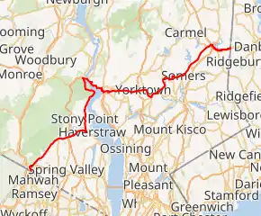
Map of New York with US 202 highlighted in red | ||||
| Route information | ||||
| Maintained by NYSDOT and Westchester County | ||||
| Length | 55.57 mi[1] (89.43 km) | |||
| Existed | June 1934[2](signage was not up until April 1, 1935[3])–present | |||
| Major junctions | ||||
| West end | ||||
| ||||
| East end | ||||
| Location | ||||
| Counties | Rockland, Orange, Westchester, Putnam | |||
| Highway system | ||||
| ||||
.svg.png.webp)
US 202's New York stretch is roughly bisected by the Hudson River. West of it, the highway runs northeast, east and north along the edge of suburbia in Rockland County to Bear Mountain Bridge; to the east, it follows a mainly east–west orientation except for the New York State Route 22 (NY 22) concurrency between Croton Falls and Brewster. It is mostly a two-lane road, expanding to four in some busier sections, with a brief limited-access stretch in Peekskill.
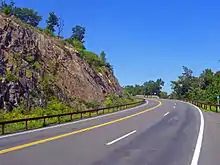
As it does in other states, US 202 serves mainly as a local road in suburban and exurban communities along the outskirts of the metropolitan area, mostly two lanes with the exception of some four-lane sections and a brief concurrency onto an expressway in Peekskill. Its course along the Hudson River takes it first north up the west side, over the historic Bear Mountain Bridge, then south along the east side. It takes in many scenic areas, such as the Ramapo Mountains and Hudson Highlands, and two New York City reservoirs.
Its circuitous path across the state puts it on many concurrencies—only 14.5 miles (23.3 km), or 26%, of US 202's mileage in New York is signed as US 202 alone. Among the roads it joins are three U.S. highways and two state routes. It forms four three-route conurrencies, including the only such grouping of three U.S. routes in the state, again in Peekskill.
Route description
Rockland and Orange counties
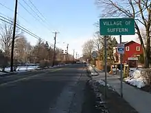
The left turn that brings US 202 into New York and the village of Suffern puts it on Orange Avenue, paralleling the old Main Line of the Erie Railroad past the Suffern train station and into the village's downtown. In the shadow of the New York State Thruway, it meets its first New York state highway, NY 59, and has a brief wrong-way concurrency with it.
Leaving Suffern behind to return to the northeastern heading it had followed across New Jersey, it crosses under the Thruway without an interchange, the end of a close parallel with Interstate 287 (I-287) that began north of Somerville, New Jersey. It remains a two-lane route at the edge of development past Pomona and Montebello, at the foot of the Ramapo Mountains, home to the vast Harriman State Park. The headwaters of the Mahwah River parallel closely.
At Ladentown, the northern terminus of NY 306, the road begins to curve to the east, away from the ridge. US 202 widens as it cuts across the county, still a little less developed here, towards Mount Ivy, where it has a full exit with Palisades Interstate Parkway and NY 45. The Long Path hiking trail also crosses here. Beyond this junction US 202 is a four-lane undivided road, surrounded mainly by office parks and commercial establishments, but not strip development, as it follows the curve of South Mountain to the south.
Development starts to increase in West Haverstraw, and at Haverstraw, the road makes an oblique intersection with US 9W and joins it, following the Hudson River north through Stony Point and then climbing the mountains near Jones Point and Bear Mountain State Park, descending to the river's level again to reach the popular picnic ground complex at Hessian Lake. Here the Appalachian Trail (AT) crosses under the road to its lowest elevation in the nearby Trailside Zoo.
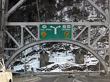
After ten miles (16 km), the US 9W concurrency comes to an end at Bear Mountain Circle, shortly after crossing into Orange County, also the Palisades Parkway's north end. US 6 replaces US 9W as the two join the AT in going through the tollbooths and crossing the Bear Mountain Bridge, entering Cortlandt in Westchester County, just south of the Putnam County line. Both US 6 and US 202 will enter Putnam County later in their routes, but for now they veer southeast, staying in Westchester.
Westchester County
In most of northern Westchester, US 202, primarily as part of concurrencies, serves as a local road between the towns it passes through. It skirts the one Putnam County village along its path, and is mostly a rural road in that county, expanded to four lines at its easternmost portion.
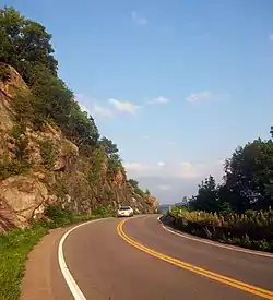
At the end of the bridge the AT leaves with NY 9D, which begins to follow the river north to Beacon and Wappingers Falls here. Routes 6 and 202 turn right to follow the NRHP-listed Bear Mountain Bridge Road.[4] The two wind around Anthony's Nose high above the river, with occasional views to Haverstraw Bay and the city of Peekskill to the south, and Dunderberg Mountain, Iona Island and the sections of US 9W the highway had just followed upriver.
Three and a half miles (6 km) US 6 and US 202 descend to river level again and, after passing the entrance to the New York National Guard base at Camp Smith, reach Annsville Circle. Here they form New York's only three-way concurrency of U.S. highways with US 9, then cross the Jans Peeck Bridge over Annsville Creek into the city and turn right onto the north end of the Croton Expressway, while Bear Mountain Parkway begins to the east. At the second exit in Peekskill, the two routes leave US 9. NY 35 begins here and replaces it in the overlap, following Main Street across the city. At South Broad Street US 202 and NY 35 turn right while US 6 continues along Main, ending the first overlap between US 6 and US 202.
A few blocks to the south, US 202 and NY 35 turn left onto Crompond Road, which takes them out of Peekskill and back into the town of Cortlandt. The two roads pass the Hudson Valley Hospital Center. Two miles later, Bear Mountain Parkway returns to US 202 for the eastern terminus of its western segment. Shortly afterwards it and Route 35 enter Yorktown.
Here the road trends to the south, and the eastern segment of Bear Mountain Parkway branches off to the left to provide access to the Taconic State Parkway, the main north–south trunk route for automobile traffic on the east side of the Hudson. An exit here allows access to neighboring Franklin D. Roosevelt State Park.
NY 132, a short local road that leads north to Route 6, begins at Old Yorktown Road. After the next major intersection at Granite Springs Road, the concurrency turns to an almost due south heading for two miles (3 km), then bends southeast into the junction with Saw Mill River Road, NY 118. Both routes turn north here, forming the third three-route overlap along US 202 in New York.
The north heading becomes northeast, then east into the town of Somers to where NY 35 leaves US 202 and NY 118 at the southwest end of Amawalk Reservoir, the first of several in the New York City water supply system along the road. US 202 and NY 118 turn left onto Tomahawk Street, closely hugging the reservoir's north shore, and then east shore after two miles (3 km), putting the road on a northern course. After crossing a small inlet at the reservoir's northwest corner, US 202 turns right, leaving NY 118. For the first time since Haverstraw, 38 miles (61 km) back, US 202 is alone, as it stays along the reservoir, heading northeast, then east, dipping south after the reservoir to pass north of Anglebrook Golf Club.
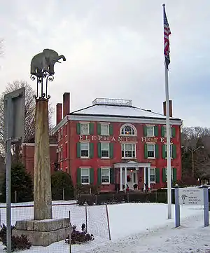
At the club's northeast corner, it turns left, as Primrose Street, the road ahead, continues as NY 139. After a mile, it turns right onto Mill Street, which becomes Somers Road shortly afterwards and curves to the south. At Brick Hill Road, it turns to a more northeast heading again, then east. This takes it into the center of town, where NY 100, Westchester's long north–south road, comes to its northern end just opposite the Elephant Hotel, Somers' town hall and a National Historic Landmark due to its role as the birthplace of the American circus.
Now Somerstown Road, the highway resumes a due-northeast heading to where NY 116 forks off to the east towards Titicus Reservoir. After this split, US 202 is now North Somerstown Road, headed northeast through generally wooded areas almost two miles (3 km) to the Croton River, where it enters a new town, North Salem. Here it forms its first concurrency in seven miles (11 km), joining with NY 22, the long north–south route along New York's eastern boundary, just north of the hamlet of Croton Falls. After crossing under the Harlem Line of the Metro-North Railroad, the two roads enter Putnam County.
Putnam County
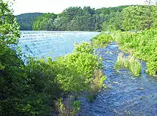
Routes 202 and 22 parallel the river and the railroad through similarly wooded country due northeast for the next two miles (3 km), with no intersections. The spillway of the lower section of East Branch Reservoir appears on the right, and then the road follows the reservoir in the same direction to the eastern outskirts of the village of Brewster. Here US 6 returns and gives US 202 its fourth three-way concurrency. Routes 6, 22 and 202 climb a small rise, cross under a rail freight spur and then pass through a developed area immediately south of the high quarter-mile bridge I-84 takes over the road and the river.
Just afterwards, the three routes turn left. The three-way overlap ends very soon afterwards at the next traffic light, where NY 22 turns left to pick up northbound traffic from I-684, which ends at the nearby junction with its parent route. The ramps to I-84 and I-684 also leave here.
The road ahead bends south and then east, a four-lane divided road making use of the thin land between I-84 and the northern section of East Branch. There is one flashing yellow light, at the northern terminus of NY 121, and then two miles (3 km) later, still next to the interstate, US 6 and US 202 cross into Danbury, Connecticut alongside it just before the Saw Mill Road exit.
History
Prior to 1934, the portion of modern US 202 within New York was known by several different designations. When the first set of posted routes in New York were assigned in 1924, the segment of what is now US 202 from the New Jersey state line to Wayne Avenue in Suffern was designated as part of NY 17. At the same time, the part now concurrent with US 9W from Haverstraw to the Bear Mountain Bridge was included in NY 10 while the section between Croton Falls and Brewster became part of NY 22.[5][6] By 1926, the Bear Mountain Bridge, the highway linking the bridge to Peekskill, and the piece of current US 202 east of Brewster were designated as part of NY 37. Although all of what became US 202 was state-maintained by this point, no other sections of the route were assigned a designation by 1926.[6]
Three portions of the route changed designations following the creation of the U.S. Highway System. In 1927, all of NY 10 south of Albany was replaced by the newly assigned US 9W.[7] NY 37, meanwhile, was replaced by a realigned US 6 one year later.[7][8][9] In the late 1920s, the segment of modern US 202 from Suffern to Haverstraw was designated as NY 61.[7][9] The last remaining unnumbered section—between Peekskill and Croton Falls—received a pair of designations as part of the 1930 renumbering of state highways in New York. From Peekskill to Somers, it became part of NY 116. At Somers, NY 116 continued east on its modern alignment toward Purdys while NY 118 followed modern US 202 northeast to Croton Falls.[9][10]
NY 61 was supplanted c. 1934 by US 122, which was extended northward from Whitehouse, New Jersey,[11][12] by way of modern County Route 523 and US 202.[2] In Suffern, US 122 utilized a small part of NY 17, which was truncated to end at US 122 in the village center.[11][12] US 122 was subsequently replaced by US 202, a new U.S. Route established by the American Association of State Highway Officials in June 1934 that extended from Bangor, Maine, to State Road, Delaware, south of Wilmington.[2] In New York, US 202 continued north from Haverstraw to the Bear Mountain Bridge over US 9W and east to Connecticut by way of overlaps with US 6, NY 116, NY 118, and NY 22.[13] The overlap with NY 116 was eliminated c. 1938 when NY 116 was truncated to its current western terminus in Somers.[14][15]
While the portion of US 202 in New York has remained relatively unchanged since the route's assignment in 1934, the overlapping routes have changed over time. The alignments of NY 118 and NY 100 north of New Croton Reservoir were flipped c. 1939, placing NY 100 on the Croton Reservoir–Croton Falls highway.[16][17] The resulting overlap between NY 100 and US 202 lasted as late as 1990;[18] however, it was eliminated by 2004 when NY 100 was cut back to end at US 202 in Somers.[19] In the early 1940s, the portion of US 202 between Peekskill and Amawalk became part of NY 35, an east–west route connecting Peekskill to Ridgefield, Connecticut.[20][21]
US 6/202 Alternate
| |
|---|---|
| Location | Putnam County, Westchester County |
U.S. Route 6/202 Alternate is a 10.5-mile (16.9 km) bypass of Bear Mountain Bridge Road, the winding segment of US 6 and US 202 between NY 9D and US 9 north of Peekskill
Major intersections
| County | Location | mi[1] | km | Destinations | Notes |
|---|---|---|---|---|---|
| Rockland | Suffern | 0.00 | 0.00 | Continuation into New Jersey | |
| 0.67 | 1.08 | Western terminus of concurrency with NY 59 | |||
| 0.72 | 1.16 | Eastern terminus of concurrency with NY 59 | |||
| Pomona | 7.35 | 11.83 | Northern terminus of NY 306 | ||
| 9.06 | 14.58 | Northern terminus of NY 45; exit 13 on Palisades Parkway | |||
| Haverstraw | 12.35 | 19.88 | Western terminus of concurrency with US 9W | ||
| Orange | Bear Mountain State Park | 22.75 | 36.61 | •Bear Mountain Circle •Eastern terminus of concurrency with US 9W •Western terminus of concurrency with US 6 •Northern terminus of the Palisades Parkway | |
| Hudson River | 23.16 | 37.27 | Bear Mountain Bridge (only tolled eastbound) Accepts E-ZPass and Cash | ||
| Westchester | Cortlandt | 23.40 | 37.66 | Southern terminus of NY 9D | |
| 26.97 | 43.40 | Annsville Circle; western terminus of concurrency with US 9 | |||
| Peekskill | 27.70 | 44.58 | Eastern terminus of concurrency with US 9; western terminus of NY 35 | ||
| 28.55 | 45.95 | Eastern terminus of concurrency with US 6 | |||
| Cortlandt | 31.21 | 50.23 | Eastern terminus of western segment of Bear Mountain Parkway | ||
| Crompond | 32.80 | 52.79 | Western terminus of eastern segment of Bear Mountain Parkway | ||
| 33.83 | 54.44 | Exit 17A on Taconic Parkway | |||
| Jefferson Valley | 34.53 | 55.57 | Southern terminus of NY 132 | ||
| Yorktown | 36.25 | 58.34 | Baldwin Road | Former eastern terminus of NY 132A | |
| Yorktown Heights | 36.56 | 58.84 | Western terminus of concurrency with NY 118 | ||
| Somers | 38.03 | 61.20 | Eastern terminus of concurrency with NY 35 | ||
| 40.85 | 65.74 | Eastern terminus of concurrency with NY 118 | |||
| 42.71 | 68.74 | Northern terminus of NY 139 | |||
| 45.23 | 72.79 | Northern terminus of NY 100 | |||
| 45.54 | 73.29 | Western terminus of NY 116 | |||
| North Salem | 47.28 | 76.09 | Western terminus of concurrency with NY 22 | ||
| Putnam | Brewster | 51.59 | 83.03 | Western terminus of concurrency with US 6 | |
| 52.53 | 84.54 | Eastern terminus of concurrency with NY 22; exit 10 on I-684; exit 68 on I-84 | |||
| Southeast | 53.27 | 85.73 | Northern terminus of NY 121; exit 69 on I-84 | ||
| 55.57 | 89.43 | Continuation into Connecticut | |||
1.000 mi = 1.609 km; 1.000 km = 0.621 mi
| |||||
See also
 U.S. Roads portal
 New York (state) portal
References
- "2008 Traffic Volume Report for New York State" (PDF). New York State Department of Transportation. June 16, 2009. pp. 183–184. Retrieved January 31, 2010.
- Weingroff, Richard (January 9, 2009). "U.S. 202 – Maine to Delaware". Highway History. Federal Highway Administration. Retrieved April 13, 2010.
- "Route Changes in State Listed". New York Post. March 30, 1935. p. 18. Retrieved June 13, 2017.
- Barry, Elise (April 29, 1982). "National Register of Historic Places nomination, Bear Mountain Bridge Road and Toll House". New York State Office of Parks, Recreation and Historic Preservation. Retrieved May 2, 2020.
- "New York's Main Highways Designated by Numbers". The New York Times. December 21, 1924. p. XX9.
- Official Map Showing State Highways and other important roads (Map). Cartography by Rand McNally and Company. State of New York Department of Public Works. 1926.
- Road Map of New York in Soconyland (Map). Cartography by General Drafting. Standard Oil Company of New York. 1927. This map shows U.S. Routes as they were first officially signed in 1927.
- Weingroff, Richard F. (July 27, 2009). "U.S. 6 – The Grand Army of the Republic Highway". Highway History. Federal Highway Administration. Retrieved July 20, 2010.
- New York in Soconyland (Map). Cartography by General Drafting. Standard Oil Company of New York. 1929.
- Road Map of New York (Map). Cartography by General Drafting. Standard Oil Company of New York. 1930.
- Texaco Road Map – New York (Map). Cartography by Rand McNally and Company. Texas Oil Company. 1933.
- Texaco Road Map – New York (Map). Cartography by Rand McNally and Company. Texas Oil Company. 1934.
- Road Map & Historical Guide – New York (Map). Cartography by Rand McNally and Company. Sun Oil Company. 1935.
- Shell Road Map – New York (Map). Cartography by H.M. Gousha Company. Shell Oil Company. 1937.
- Thibodeau, William A. (1938). The ALA Green Book (1938–39 ed.). Automobile Legal Association.
- New York Road Map for 1938 (Map). Cartography by General Drafting. Esso. 1938.
- New York (Map). Cartography by General Drafting. Standard Oil Company. 1939.
- Croton Falls Digital Raster Quadrangle (Map). 1:24,000. New York State Department of Transportation. 1990. Retrieved March 31, 2010.
- New York State Department of Transportation (October 2004). Official Description of Highway Touring Routes, Scenic Byways, & Bicycle Routes in New York State (PDF). Retrieved July 17, 2009.
- New York Info-Map (Map). Cartography by Rand McNally and Company. Gulf Oil Company. 1940.
- New York with Pictorial Guide (Map). Cartography by General Drafting. Esso. 1942.
External links
| Wikimedia Commons has media related to U.S. Route 202 in New York (state). |
- U.S. Route 202 at Alps' Roads • New York Routes
- Mile by Mile travel guide
| Previous state: New Jersey |
New York | Next state: Connecticut |