Nebraska Highway 1
Nebraska Highway 1 (N‑1) is a 26.88-mile (43.26 km) state highway in Cass County, Nebraska, United States. Its western terminus is at U.S. Route 34 (US 34) south of Elmwood, and its eastern terminus is at US 34/US 75 east of Murray.
| ||||
|---|---|---|---|---|
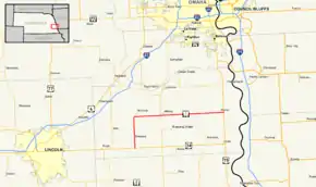 Nebraska Highway 1 highlighted in red | ||||
| Route information | ||||
| Maintained by NDOT | ||||
| Length | 26.88 mi[1] (43.26 km) | |||
| Existed | 1926–present | |||
| Major junctions | ||||
| West end | ||||
| East end | ||||
| Location | ||||
| Counties | Cass | |||
| Highway system | ||||
| ||||

Route description

N‑1 begins at an intersection with US 34 about 2 miles (3.2 km) south of Elmwood. (US 34 heads west to Eagle and Lincoln and heads east to Union and the eastern terminus of N‑1. The road continues south as South 29th Street toward Unadilla.) From its western terminus, N‑1 heads north as a two-lane road through hilly farmland until it crosses Stove Creek and reaches Elmwood. Just inside the limits of the village N‑1 crosses the MoPac Trail East. Within the village the route is known as 4th Street, and it passes by the business district of the village and a community park as it traverses from south to north. N‑1 then leaves the limits of Elmwood and crosses Weeping Water Creek. Continuing north of Elmwood, the highway crosses Fletcher Avenue (a main east-west road in Cass County) and then crosses Beaver Creek before curving to the east. Just east of this bend, the route intersects with the south end of Nebraska Spur 13A, a short spur route that connects N‑1 with the small nearby village of Murdock.[2] The road changes its direction from north-south to east-west at this junction.
.JPG.webp)
The route continues about 5.5 miles (8.9 km) east through more hilly farmland to an intersection with Nebraska Highway 50. East of this intersection, the route passes over South Cedar Creek and connects with the southern end of Manley Lane, the main access road to the nearby village of Manley. Immediately east of Manley Lane, N‑1 crosses a single set of Union Pacific Railroad (UP) tracks.[3] About one mile (1.6 km) east of the Manley area, N-1 serves the Cass County Fairgrounds, then continues east toward Murray. The route passes by Conestoga High School before entering the village limits. N-1 is known as Main Street in Murray, and it passes through the village from west to east. It heads through the business district, then traverses a viaduct over another line of the UP[3] before exiting the village. Just east of Murray, N-1 reaches its western terminus at an intersection with US 34/US 75. (From the intersection US 34/US 75 heads north to Plattsmouth, Nebraska Highway 66, and the Platte River and heads south to Nebraska City. The road continues east as Murray Road to Beaver Lake and 27th Avenue.)[2]
The route is maintained by the Nebraska Department of Roads (NDOR). In 2012, NDOR calculated traffic volume on its highways in terms of average annual daily traffic (AADT). N‑1 had as many as 2385 vehicles, including 115 heavy commercial vehicles, between Murray and its eastern terminus, and as few as 695 vehicles, including 75 heavy commercial vehicles, between its intersections with S‑13A and N‑50.[4]
History
N‑1 was originally designated in 1925 between Harrison and South Sioux City in the northern part of the state, replacing Nebraska Highway 79, Nebraska Highway 78, Nebraska Highway 77, Nebraska Highway 65, and Nebraska Highway 49. In 1926, this highway became U.S. Route 20, and the N‑1 designation was transferred to its current route. This route was originally signed as Nebraska Highway 24 in 1922 and changed to Nebraska Highway 5A in 1925, and Nebraska Highway 30 in 1926 before becoming Nebraska Highway 1.[5]
Major intersections
The entire route is in Cass County. [2]
| Location[2] | mi[1] | km | Destinations | Notes | |
|---|---|---|---|---|---|
| | 0.00 | 0.00 | Counterclockwise terminus; road continues south as 298th Street | ||
| 7.38 | 11.88 | Signage changes the highway's direction from south-north to east-west at this intersection | |||
| 12.91 | 20.78 | ||||
| 26.88 | 43.26 | Clockwise terminus; road continues east as Murray Road | |||
| 1.000 mi = 1.609 km; 1.000 km = 0.621 mi | |||||
References
- "Nebraska Highway Reference Log Book" (PDF). Nebraska Department of Roads. 2015. p. 1. Retrieved January 6, 2017.
- Google (August 17, 2014). "N-1 – Western terminus to S-13A" (Map). Google Maps. Google. Retrieved August 17, 2014.
Google (August 17, 2014). "N-1 – S-13A to eastern terminus" (Map). Google Maps. Google. Retrieved August 17, 2014. - Nebraska Railroads (PDF) (Map). Nebraska Department of Roads. January 1, 2012. Archived from the original (PDF) on March 4, 2014. Retrieved August 17, 2014.
- Traffic Flow Map of the State Highways (PDF) (Map). Nebraska Department of Roads. 2013. Archived from the original (PDF) on February 28, 2014. Retrieved August 17, 2014.
- Geelhart, Chris. "Nebraska Highways 1 to 30 (Highway 5A)". The Nebraska Highways Page. Archived from the original on June 29, 2011. Retrieved March 3, 2009 – via Wayback Machine.
External links
| Wikimedia Commons has media related to Nebraska Highway 1. |