Interstate 680 (Nebraska–Iowa)
Interstate 680 (I-680) in Nebraska and Iowa is the northern bypass of the Omaha – Council Bluffs metropolitan area. I-680 spans 16.49 miles (26.54 km) from its southern end in western Omaha to its eastern end near Crescent, Iowa. The freeway passes through a diverse range of scenes and terrains – the urban setting of Omaha, the Missouri River and its valley, the rugged Loess Hills, and the farmland of Pottawattamie County, Iowa.
| |||||||||
|---|---|---|---|---|---|---|---|---|---|
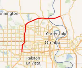
I-680 highlighted in red | |||||||||
| Route information | |||||||||
| Auxiliary route of I-80 | |||||||||
| Maintained by NDOR and Iowa DOT | |||||||||
| Length | 16.49 mi[1] (26.54 km) | ||||||||
| Existed | December 13, 1966[4]–present | ||||||||
| Major junctions | |||||||||
| South end | |||||||||
| East end | |||||||||
| Location | |||||||||
| States | |||||||||
| Counties |
| ||||||||
| Highway system | |||||||||
| |||||||||

From 1973 until 2019, I-680 extended much farther into Iowa. It followed I-29 for 10 miles (16 km) between Crescent and Loveland. It then headed east along what is now known as I-880 until it met I-80 again near Neola, Iowa. The I-880 section was originally known as Interstate 80N from 1966 until it was absorbed into I-680 in 1973. I-680 in Omaha was originally designated Interstate 280. Maps from the early and mid-1960s showed I-280 in Omaha. Since this highway would extend into Iowa, and I-280 was already planned for the Quad Cities area, this route was redesignated I-680.
Route description

Interstate 680 begins at a complex interchange with I-80 in Omaha. Due to the proximity of the West Center Road interchange on I-680 and the I, L and Q Street interchanges on I-80, all of the exit and entrance ramps which connect I-80 to I-680 also connect to West Center Road and I, L and Q Streets. The freeway heads north through the heart of West Omaha; it serves as a dividing line of several residential neighborhoods.[5][6] Two miles (3.2 km) north of West Center Road, which prior to 2003 was N-38,[7] is a new interchange with U.S. Route 6 (US 6), known as Dodge Street in Omaha.[2] Another mile north of Dodge Street is N-64, known as Maple Street.[2]
At N-133, I-680 turns to the east towards Iowa. South of this interchange, I-680 travels through residential neighborhoods, but to the east, the population thins and the interstate passes through farmland for 4 1⁄2 miles (7.2 km).[8] I-680 crosses over N-36, which is accessed via the US 75 interchange 1⁄2 mile (0.80 km) later. US 75 runs adjacent to I-680 for one mile (1.6 km) before turning south at 30th Street.[2] The interstate crosses the Missouri River to Iowa via the Mormon Bridge.[9] In Iowa, Interstate 680 is markedly less urban than in Nebraska. The first three miles (4.8 km) of I-680 travel through the flat bottoms of the Missouri River valley.[10] I-680 ends at an interchange with I-29 just west of Crescent.
History
| |
|---|---|
| Location | Omaha, Nebraska |
| Existed | 1958–1965 |
In Nebraska, plans for Interstate 280 to bypass Omaha to the north to I-29 were drawn up in the late 1950s. At the same time, plans were being drawn up for an Interstate 280 to bypass the Quad Cities. Since two interstates cannot have the same designation in the same state, one of the I-280s had to be renumbered. The Omaha I-280 was re-designated as I-680 around 1965.[11] In Iowa, Interstate 80N opened to traffic on December 13, 1966.[4] I-80N extended from the current northern interchange with I-29 near Loveland to the I-80 interchange near Neola.
In the early 1970s, AASHTO, the American Association of State Highway Transportation Officials, decided that interstates with a directional suffix, such as I-80N, would have to be renumbered.[12] By 1974, I-80N had been re-designated to I-680 to match Nebraska.[13] The last piece of I-680 to be completed in Nebraska was the westbound bridge across the Missouri River.[14] Paving in Iowa wrapped up in the years to come and the entire route was open to traffic by April 21, 1979.[4]
2011 flooding

Over the course of several months in 2011, I-680 was severely damaged by flood waters from the Missouri River. The first sections of both I-680 and I-29 closed on June 10. I-29 was closed from North 25th Street to the northern I-680 interchange near Loveland. I-680 was closed from US 75 in Omaha to the southern interchange with I-29.[15] A week later, water was diverted and drained from the area around the northern I-29 interchange to allow traffic to use the roads. I-680 was opened from the interchange to the Beebeetown exit and I-29 was reopened from the interchange to the US 30 exit at Missouri Valley. I-29 traffic was routed around the flooded area by using I-680 eastbound to I-80 westbound to Council Bluffs.[16]
After flood waters receded and the damage was assessed, sections of I-680 were reopened to traffic. However, the section west of I-29 was the most heavily damaged and it remained closed. Contract bids were let on September 23 and reconstruction began on September 28.[17] Construction crews worked at "an accelerated pace" to complete the road in 34 days.[18] The road was officially reopened on November 2 during a ceremony in Crescent hosted by Governor Terry Branstad.[19]
Exit list
| State | County | Location | mi[2][3] | km | Exit | Destinations | Notes |
|---|---|---|---|---|---|---|---|
| Nebraska | Douglas | Omaha | 0.00 | 0.00 | 446 | I-80 exit 446; exit number is for I-80 westbound; exit number based on I-80 mileage | |
| 0.72 | 1.16 | 1 | No southbound entrance; southbound exit uses C/D lanes; West Center Road is former N-38; northbound exit signed as West Center Road only | ||||
| 1.73 | 2.78 | 2 | Pacific Street | ||||
| 2.91 | 4.68 | 3 | There are direct exit and entrance ramps to/from Old Mill, 114th Street, and 120th Street | ||||
| 4.48 | 7.21 | 4 | |||||
| 5.93 | 9.54 | 5 | Fort Street | ||||
| 7.03 | 11.31 | 6 | |||||
| 9.75 | 15.69 | 9 | 72nd Street | ||||
| 11.99 | 19.30 | 12 | Former US 73 | ||||
| 12.94 | 20.82 | 13 | 30th Street (L-28H) – Eppley Airfield | L-28H unsigned | |||
| Missouri River | 13.32 0.000 | 21.44 0.000 | Mormon Bridge | ||||
| Iowa | Pottawattamie | Crescent Township | 1.099 | 1.769 | 1 | County Road | [20] |
| Crescent | 3.169 | 5.100 | 3 | Signed as 3A (south) and 3B (east); I-29 exit 61B | |||
1.000 mi = 1.609 km; 1.000 km = 0.621 mi
| |||||||
See also
- North Omaha, Nebraska
- History of North Omaha, Nebraska
- Timeline of North Omaha, Nebraska history
- Landmarks in North Omaha, Nebraska
References
- Federal Highway Administration. "Route Log - Auxiliary Routes of the Eisenhower National System Of Interstate and Defense Highways - Table 2". Retrieved March 8, 2010.
- "Nebraska Highway Reference Log Book" (PDF). Nebraska Department of Roads. 2015. pp. 311–312. Retrieved January 8, 2017.
- 2009 Volume of Traffic on the Primary Road System of Iowa (PDF) (Report). Iowa Department of Transportation. January 1, 2009. Retrieved April 1, 2010.
- Iowa Department of Transportation (1996). The National System of Interstate Defense Highways 1956–1996.
- Neighborhood Associations (PDF) (Map). City of Omaha. Archived from the original (PDF) on May 9, 2012. Retrieved January 25, 2012.
- Google (January 26, 2012). "I-680 south of N-133 interchange" (Map). Google Maps. Google. Retrieved January 26, 2012.
- "End of the historic road as Nebraska Highway 38 goes off the map". Omaha World-Herald. January 10, 2003.
- Google (January 26, 2012). "I-680 at N-133 interchange" (Map). Google Maps. Google. Retrieved January 26, 2012.
- Janberg, Nicolas. "Mormon Bridge (1952)". Structurae. Retrieved January 20, 2012.
- Google (January 26, 2012). "I-680 through Iowa" (Map). Google Maps. Google. Retrieved January 26, 2012.
- 1965 Iowa State Highway Map (PDF) (Map). Iowa State Highway Commission. Retrieved April 1, 2010.
- AASHTO (January 2000). "Establishment of a Marking System of the Routes Comprising the National System of Interstate and Defense Highways" (PDF). Archived from the original (PDF) on November 1, 2006. Retrieved April 1, 2010.
- 1974 Iowa State Highway Map (PDF) (Map). Iowa State Highway Commission. Retrieved April 1, 2010.
- Koster, George E. (1997). "A Story of Highway Development in Nebraska" (PDF). Nebraska Department of Roads. p. 82. Retrieved April 1, 2010.
- "Updated Flood Summary: Additional Sections Of 2 Interstates Closed". Des Moines, Iowa: KCCI. June 11, 2011. Archived from the original on November 3, 2011. Retrieved November 3, 2011.
- "Critical I-29, I-680 Interchange Reopens To Traffic". Des Moines, Iowa: KCCI. June 17, 2011. Archived from the original on November 3, 2011. Retrieved November 3, 2011.
- "Bids opened on I-680 rebuilding project in Pottawattamie County". Iowa Department of Transportation. Retrieved November 3, 2011.
- "Interstate 680 to reopen on Nov. 2; grand reopening ceremony planned". Iowa Department of Transportation. Retrieved November 3, 2011.
- "I-680 grand reopening ceremony to be held in Crescent". Iowa Department of Transportation. Retrieved November 3, 2011.
- Google (August 22, 2009). "Exit 1 in Iowa" (Map). Google Maps. Google. Retrieved August 22, 2009.
External links
| ||
| ||