Nebraska Highway 43
Nebraska Highway 43 (N-43) is a highway in southeastern Nebraska. It runs for a length of 30 miles (48 km) in a south-to-north direction. Its southern terminus is near Adams at an intersection with N-41. Its northern terminus is at an intersection with U.S. Highway 34 (US 34) in Eagle.
| ||||
|---|---|---|---|---|
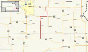 Nebraska Highway 43 highlighted in red | ||||
| Route information | ||||
| Maintained by NDOT | ||||
| Length | 30.22 mi[1] (48.63 km) | |||
| Major junctions | ||||
| South end | ||||
| North end | ||||
| Location | ||||
| Counties | Gage, Lancaster, Otoe, Cass | |||
| Highway system | ||||
| ||||

Route description
Nebraska Highway 43 begins near Adams at an intersection with N-41. The highway heads due north into farmland until Bennet. Shortly after Bennet, the highway meets N-2. N-2 and N-43 overlap until Palmyra, which is where N-43 turns north. N-43 goes north for four miles (6 km), west for one, and then north for three more miles, where it meets US 34 in Eagle and ends.[1][2]
Major intersections
| County | Location | mi[1] | km | Destinations | Notes |
|---|---|---|---|---|---|
| Gage | Adams | 0.00 | 0.00 | ||
| Lancaster | Panama | 9.01 | 14.50 | ||
| | 17.07 | 27.47 | Interchange, southern end of N-2 overlap | ||
| Otoe | Palmyra | 22.40 | 36.05 | Northern end of N-2 overlap | |
| Cass | Eagle | 30.22 | 48.63 | ||
1.000 mi = 1.609 km; 1.000 km = 0.621 mi
| |||||
References
- "Nebraska Highway Reference Log Book" (PDF). Nebraska Department of Roads. 2015. p. 139. Retrieved January 7, 2017.
- Google (2010-11-05). "overview of Nebraska Highway 43" (Map). Google Maps. Google. Retrieved 2010-11-05.
This article is issued from Wikipedia. The text is licensed under Creative Commons - Attribution - Sharealike. Additional terms may apply for the media files.