Lancaster County, Nebraska
Lancaster County is a county located in the U.S. state of Nebraska. As of the 2010 United States Census, the population was 285,407,[1] making it the second-most populous county in Nebraska. Its county seat is Lincoln,[2] the state capital. The county was created in 1859.
Lancaster County | |
|---|---|
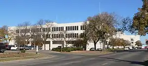 Lancaster County Courthouse in Lincoln | |
 Flag  Seal | |
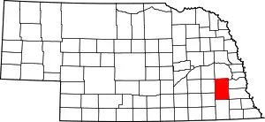 Location within the U.S. state of Nebraska | |
 Nebraska's location within the U.S. | |
| Coordinates: 40°47′N 96°41′W | |
| Country | |
| State | |
| Founded | 1859 |
| Seat | Lincoln |
| Largest city | Lincoln |
| Area | |
| • Total | 846 sq mi (2,190 km2) |
| • Land | 838 sq mi (2,170 km2) |
| • Water | 8.8 sq mi (23 km2) 1.0%% |
| Population | |
| • Estimate (2019) | 319,090 |
| • Density | 375/sq mi (145/km2) |
| Time zone | UTC−6 (Central) |
| • Summer (DST) | UTC−5 (CDT) |
| Congressional district | 1st |
| Website | lancaster |
Lancaster County is part of the Lincoln, NE Metropolitan Statistical Area.
In the Nebraska license plate system, Lancaster County was represented by the prefix 2 (it had the second-largest number of vehicles registered in the state when the license plate system was established in 1922). In 2002, the state discontinued the 1922 system in Lancaster, Douglas and Sarpy counties.
Geography
According to the US Census Bureau, the county has a total area of 846 square miles (2,190 km2), of which 838 square miles (2,170 km2) is land and 8.8 square miles (23 km2) (1.0%) is water.[3]
Major highways
Climate
In 2004,[4] Lancaster County was named a StormReady county by the National Weather Service.[5]
Adjacent counties
- Saunders County – north
- Cass County – northeast
- Otoe County – southeast
- Johnson County – southeast
- Gage County – south
- Saline County – southwest
- Seward County – northwest
- Butler County – northwest
Protected areas
- Bluestem Lake State Recreation Area[6]
- Branched Oak State Recreation Area
- Conestoga Lake State Recreation Area[7]
- Frank Shoemaker Marsh (part of Lincoln Parks & Recreation System)[8]
- Holmes Lake Recreation Area[9]
- Olive Creek Lake State Recreation Area[10]
- Pawnee State Recreation Area
- Pioneers Park Nature Center
- Stagecoach Lake State Recreation Area[11]
- Wagon Train Lake State Recreation Area[12]
- Wildwood Lake State Wildlife Management Area[13]
- Yankee Hill State Wildlife Management Area[14]
Demographics
| Historical population | |||
|---|---|---|---|
| Census | Pop. | %± | |
| 1860 | 153 | — | |
| 1870 | 7,074 | 4,523.5% | |
| 1880 | 28,090 | 297.1% | |
| 1890 | 76,395 | 172.0% | |
| 1900 | 64,835 | −15.1% | |
| 1910 | 73,793 | 13.8% | |
| 1920 | 85,902 | 16.4% | |
| 1930 | 100,324 | 16.8% | |
| 1940 | 100,585 | 0.3% | |
| 1950 | 119,742 | 19.0% | |
| 1960 | 155,272 | 29.7% | |
| 1970 | 167,972 | 8.2% | |
| 1980 | 192,884 | 14.8% | |
| 1990 | 213,641 | 10.8% | |
| 2000 | 250,291 | 17.2% | |
| 2010 | 285,407 | 14.0% | |
| 2019 (est.) | 319,090 | [15] | 11.8% |
| US Decennial Census[16] 1790–1960[17] 1900–1990[18] 1990–2000[19] 2010–2019[1] | |||
As of the 2000 United States Census,[20] there were 250,291 people, 99,187 households, and 60,702 families in the county. The population density was 298 people per square mile (115/km2). There were 104,217 housing units at an average density of 124 per square mile (48/km2). The racial makeup of the county was 90.07% White, 2.82% Black or African American, 0.64% Native American, 2.86% Asian American, 0.06% Pacific Islander, 1.69% from other races, and 1.87% from two or more races. 3.37% of the population were Hispanic or Latino of any race. 39.1% were of German, 7.9% English and 7.8% Irish ancestry.
There were 99,187 households, out of which 30.30% had children under the age of 18 living with them, 48.80% were married couples living together, 9.10% had a female householder with no husband present, and 38.80% were non-families. 29.10% of all households were made up of individuals, and 8.30% had someone living alone who was 65 years of age or older. The average household size was 2.40 and the average family size was 3.00.
The county population contained 23.50% under the age of 18, 15.40% from 18 to 24, 30.40% from 25 to 44, 20.30% from 45 to 64, and 10.40% who were 65 years of age or older. The median age was 32 years. For every 100 females, there were 99.80 males. For every 100 females age 18 and over, there were 98.50 males.
The median income for a household in the county was $41,850, and the median income for a family was $53,676. Males had a median income of $34,720 versus $25,614 for females. The per capita income for the county was $21,265. About 5.50% of families and 9.50% of the population were below the poverty line, including 9.90% of those under age 18 and 6.10% of those age 65 or over.
Communities
Census-designated places
Other unincorporated communities
Census divisions
Lancaster County is divided into the following census divisions, called precincts, except for the City of Lincoln.
- Buda
- Centerville
- Denton
- Elk
- Grant
- Highland
- Lancaster
- City of Lincoln
- Lincoln
- Little Salt
- Middle Creek
- Mill
- Nemaha
- North Bluff
- Oak
- Olive Branch
- Panama
- Rock Creek
- Saltillo
- South Pass
- Stevens Creek
- Stockton
- Waverly
- West Oak
- Yankee Hill
Politics
Lancaster County has historically been somewhat conservative for an urban county. In the last 30 national elections, Lancaster County selected the Republican Party candidate 78% of the time. However, it has become more competitive in recent years, largely due to the influence of Lincoln and the University of Nebraska. Since 1988, the margin in the county has been 10 points or less all but once. In 2008, Barack Obama won a narrow majority in Lancaster County, becoming the first Democrat to carry the county since 1964, and only the second since 1936. The county gave a narrow plurality to Hillary Clinton in 2016. As of December 2020, Republicans maintain a small edge in party registration in the county.[21]
| Democratic | Republican | Libertarian | Non-Partisan | Total |
|---|---|---|---|---|
| 72,782 (35.87%) | 80,345 (39.6%) | 3,404 (1.68%) | 46,365 (22.85%) | 202,896 (100%) |
| Year | Republican | Democratic | Third Parties |
|---|---|---|---|
| 2020 | 44.6% 70,092 | 52.3% 82,293 | 3.1% 4,830 |
| 2016 | 45.2% 61,588 | 45.4% 61,898 | 9.4% 12,737 |
| 2012 | 49.0% 62,434 | 48.7% 62,015 | 2.3% 2,906 |
| 2008 | 46.6% 59,398 | 51.6% 65,734 | 1.9% 2,358 |
| 2004 | 56.0% 69,764 | 42.4% 52,747 | 1.6% 1,998 |
| 2000 | 51.8% 55,514 | 41.7% 44,650 | 6.5% 6,968 |
| 1996 | 45.9% 44,812 | 44.4% 43,339 | 9.8% 9,557 |
| 1992 | 39.5% 41,590 | 39.3% 41,402 | 21.3% 22,407 |
| 1988 | 49.9% 44,744 | 49.5% 44,396 | 0.7% 583 |
| 1984 | 59.3% 48,778 | 40.0% 32,898 | 0.7% 569 |
| 1980 | 50.9% 38,780 | 35.6% 27,162 | 13.5% 10,291 |
| 1976 | 56.5% 39,041 | 40.9% 28,301 | 2.6% 1,789 |
| 1972 | 62.2% 42,573 | 37.9% 25,924 | |
| 1968 | 55.5% 33,051 | 39.5% 23,539 | 4.9% 2,940 |
| 1964 | 40.9% 23,887 | 59.1% 34,503 | |
| 1960 | 62.6% 37,725 | 37.4% 22,564 | |
| 1956 | 64.9% 35,591 | 35.1% 19,217 | |
| 1952 | 67.5% 36,797 | 32.5% 17,728 | |
| 1948 | 56.3% 23,620 | 43.7% 18,338 | |
| 1944 | 58.0% 26,715 | 42.0% 19,338 | |
| 1940 | 58.6% 27,384 | 41.4% 19,321 | |
| 1936 | 47.4% 20,902 | 50.7% 22,366 | 1.9% 838 |
| 1932 | 52.3% 20,772 | 45.8% 18,190 | 1.9% 761 |
| 1928 | 75.2% 30,523 | 24.2% 9,840 | 0.6% 242 |
| 1924 | 54.4% 18,061 | 34.8% 11,563 | 10.8% 3,575 |
| 1920 | 62.6% 15,638 | 33.8% 8,435 | 3.7% 917 |
| 1916 | 42.2% 7,042 | 54.5% 9,093 | 3.3% 553 |
| 1912 | 18.2% 2,566 | 47.5% 6,708 | 34.4% 4,857 |
| 1908 | 45.2% 7,428 | 51.9% 8,540 | 3.0% 485 |
| 1904 | 70.8% 8,167 | 17.2% 1,981 | 12.1% 1,393 |
| 1900 | 55.3% 7,465 | 42.0% 5,677 | 2.7% 365 |
| 1896 | 52.1% 6,513 | 45.5% 5,687 | 2.2% 284 |
| 1892 | 52.6% 5,858 | 11.5% 1,283 | 35.7% 3,977 |
| 1888 | 56.9% 5,677 | 35.2% 3,508 | 7.8% 780 |
| 1884 | 62.6% 4,011 | 34.0% 2,180 | 3.2% 207 |
| 1880 | 69.5% 3,397 | 28.2% 1,381 | 2.2% 110 |
Notable native
- Leon Riley (1906–1970), American minor league baseball player/manager (born in Princeton, Nebraska).
References
- "State & County QuickFacts". US Census Bureau. Retrieved September 21, 2013.
- "Find a County". National Association of Counties. Retrieved 7 June 2011.
- "2010 Census Gazetteer Files". US Census Bureau. August 22, 2012. Archived from the original on November 13, 2013. Retrieved December 9, 2014.
- "cpsws2004photos5". High Plains Regional Climate Center. Retrieved December 2, 2013.
- "Nebraska StormReady Communities". National Weather Service. Archived from the original on December 8, 2013. Retrieved December 2, 2013.
- Bluestem Lake State Recreation Area Google Maps (accessed 21 January 2019)
- Conestoga Lake State Recreation Area, Denton NE Google Maps (accessed 21 January 2019)
- Frank Shoemaker Marsh Google Maps (accessed 21 January 2019)
- Holmes Lake Recreation Area Google Maps (accessed 21 January 2019)
- Olive Creek Lake State Recreation Area, Hallam NE Google Maps (accessed 21 January 2019)
- Stagecoach Lake State Recreation Area Google Maps (accessed 21 January 2019)
- Wagon Train Lake State Recreation Area Google Maps (accessed 21 January 2019)
- Wildwood Lake State Management Area, Valparaiso NE Google Maps (accessed 21 January 2019)
- Yankee Hill State Wildlife Management Area Google Maps (accessed 21 January 2019)
- "Population and Housing Unit Estimates". Retrieved March 26, 2020.
- "US Decennial Census". US Census Bureau. Retrieved December 9, 2014.
- "Historical Census Browser". University of Virginia Library. Retrieved December 9, 2014.
- "Population of Counties by Decennial Census: 1900 to 1990". US Census Bureau. Retrieved December 9, 2014.
- "Census 2000 PHC-T-4. Ranking Tables for Counties: 1990 and 2000" (PDF). US Census Bureau. Retrieved December 9, 2014.
- "U.S. Census website". US Census Bureau. Retrieved 31 January 2008.
- "2020 Eligible Voter Statistics" (PDF). Nebraska Secretary of State. December 1, 2020.
- Election Results
External links
| Wikimedia Commons has media related to Lancaster County, Nebraska. |
Places adjacent to Lancaster County, Nebraska | ||||||||||
|---|---|---|---|---|---|---|---|---|---|---|
| ||||||||||
Municipalities and communities of Lancaster County, Nebraska, United States | ||
|---|---|---|
| Cities | Map of Nebraska highlighting Lancaster County | |
| Villages | ||
| CDPs | ||
| Other unincorporated communities | ||
| Footnotes | ‡This populated place also has portions in an adjacent county or counties | |
| ||

| Authority control |
|---|